File:West Didsbury map 1911.jpg

Size of this preview: 780 × 599 pixels. Other resolutions: 312 × 240 pixels | 625 × 480 pixels | 999 × 768 pixels | 1,076 × 827 pixels.
Original file (1,076 × 827 pixels, file size: 440 KB, MIME type: image/jpeg)
Captions
Captions
Add a one-line explanation of what this file represents
Summary edit
| Description |
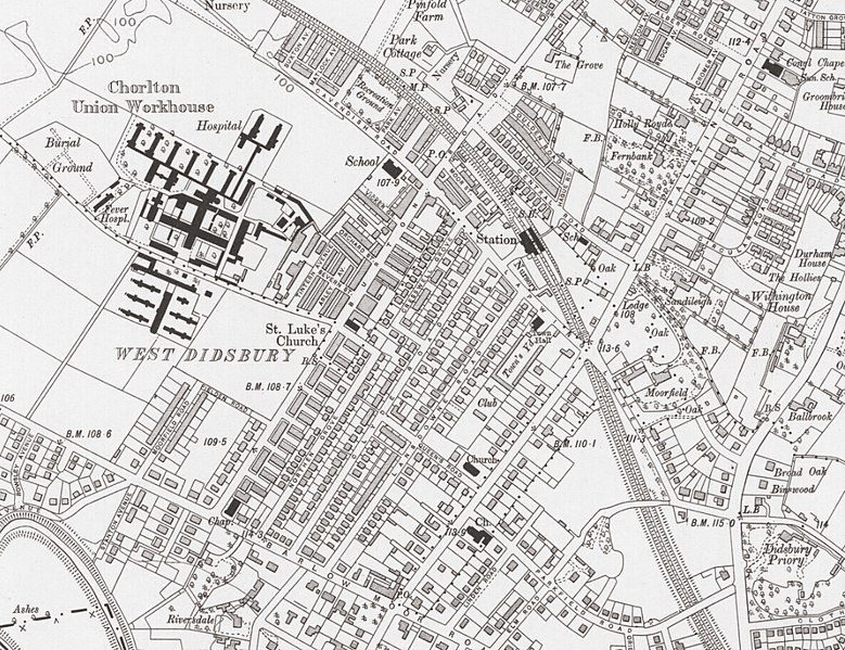
English: OS map of West Didsbury, 1907-8 |
| Date | |
| Source |
Ordnance Survey map Cheshire X.SW (includes: Cheadle and Gatley; Manchester; Stockport.) Published 1911 |
| Author | Ordnance Survey |
Licensing edit
This work is an Ordnance Survey map over 50 years old, which is covered by Crown Copyright which in this case expires 50 years after publication. Ordnance Survey does however ask that they be credited and that the date of publication be given.
Any ancillary rights gained through the creation of the electronic version are granted as freely usable under any circumstances.
|
This work created by the United Kingdom Government is in the public domain.
This is because it is one of the following:
HMSO has declared that the expiry of Crown Copyrights applies worldwide (ref: HMSO Email Reply)
|
 |
File history
Click on a date/time to view the file as it appeared at that time.
| Date/Time | Thumbnail | Dimensions | User | Comment | |
|---|---|---|---|---|---|
| current | 17:45, 6 November 2017 | | 1,076 × 827 (440 KB) | Cnbrb (talk | contribs) | User created page with UploadWizard |
You cannot overwrite this file.
File usage on Commons
The following page uses this file:
File usage on other wikis
The following other wikis use this file:
- Usage on en.wikipedia.org