File:West Midlands Metro schematic.png

Size of this preview: 800 × 410 pixels. Other resolutions: 320 × 164 pixels | 640 × 328 pixels | 1,024 × 524 pixels | 1,280 × 656 pixels | 2,841 × 1,455 pixels.
Original file (2,841 × 1,455 pixels, file size: 130 KB, MIME type: image/png)
Captions
Captions
West Midlands Metro schematic map
Summary edit
| Description |
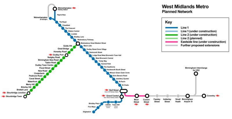
English: Schematic map of the West Midlands Metro light rail network around Birmingham, UK, showing Line 1 and planned and proposed extensions |
| Date | |
| Source | Own work |
| Author | Cnbrb |
Licensing edit
I, the copyright holder of this work, hereby publish it under the following license:
| This file is made available under the Creative Commons CC0 1.0 Universal Public Domain Dedication. | |
| The person who associated a work with this deed has dedicated the work to the public domain by waiving all of their rights to the work worldwide under copyright law, including all related and neighboring rights, to the extent allowed by law. You can copy, modify, distribute and perform the work, even for commercial purposes, all without asking permission.
|
File history
Click on a date/time to view the file as it appeared at that time.
| Date/Time | Thumbnail | Dimensions | User | Comment | |
|---|---|---|---|---|---|
| current | 11:12, 8 May 2024 | | 2,841 × 1,455 (130 KB) | Cnbrb (talk | contribs) | recent updates, line construction, HS2 route |
| 07:34, 17 July 2022 |  | 2,841 × 1,455 (124 KB) | Cnbrb (talk | contribs) | Edgbaston extension is now open | |
| 13:11, 13 December 2019 |  | 2,841 × 1,455 (124 KB) | Cnbrb (talk | contribs) | updated with 2019 extension to Centenary Sq | |
| 10:15, 3 September 2019 |  | 2,841 × 1,455 (125 KB) | Cnbrb (talk | contribs) | User created page with UploadWizard |
You cannot overwrite this file.
File usage on Commons
The following 19 pages use this file:
- User:Chumwa/OgreBot/Potential transport maps/2019 December 11-20
- User:Chumwa/OgreBot/Potential transport maps/2019 September 1-10
- User:Chumwa/OgreBot/Public transport information/2019 December 11-20
- User:Chumwa/OgreBot/Public transport information/2019 September 1-10
- User:Chumwa/OgreBot/Public transport information/2022 July 11-20
- User:Chumwa/OgreBot/Public transport information/2024 May 1-10
- User:Chumwa/OgreBot/Transport Maps/2019 December 11-20
- User:Chumwa/OgreBot/Transport Maps/2019 September 1-10
- User:Chumwa/OgreBot/Transport Maps/2022 July 11-20
- User:Chumwa/OgreBot/Transport Maps/2024 May 1-10
- User:Chumwa/OgreBot/Travel and communication maps/2019 December 11-20
- User:Chumwa/OgreBot/Travel and communication maps/2019 September 1-10
- User:Chumwa/OgreBot/Travel and communication maps/2022 July 11-20
- User:Chumwa/OgreBot/Travel and communication maps/2024 May 1-10
- User:Mattbuck/Railways/2019 December
- User:Mattbuck/Railways/2019 September
- User:Mattbuck/Railways/2022 July
- User:Mattbuck/Railways/2024 May
- User:OgreBot/Watercraft/2019 September 3
File usage on other wikis
The following other wikis use this file:
- Usage on en.wikipedia.org
- Usage on eo.wikipedia.org