File:West side and north rear. View to southeast. - Black Hills and Fort Pierre Railroad Roundhouse, Terraville Avenue and Sunnyhill Road, Lead, Lawrence County, SD HAER SD-52-7.tif

Size of this JPG preview of this TIF file: 750 × 600 pixels. Other resolutions: 300 × 240 pixels | 601 × 480 pixels | 961 × 768 pixels | 1,280 × 1,023 pixels | 2,560 × 2,046 pixels | 5,258 × 4,203 pixels.
Original file (5,258 × 4,203 pixels, file size: 21.08 MB, MIME type: image/tiff)
Captions
Captions
Add a one-line explanation of what this file represents
Summary edit
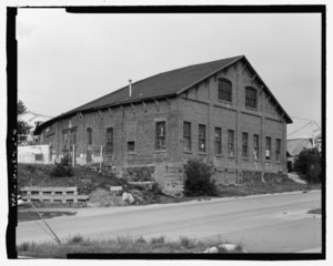
| West side and north rear. View to southeast. - Black Hills and Fort Pierre Railroad Roundhouse, Terraville Avenue and Sunnyhill Road, Lead, Lawrence County, SD | ||||
|---|---|---|---|---|
| Title |
West side and north rear. View to southeast. - Black Hills and Fort Pierre Railroad Roundhouse, Terraville Avenue and Sunnyhill Road, Lead, Lawrence County, SD |
|||
| Description |
Fraserdesign, contractor; South Dakota State Historical Society, sponsor; Fraser, Clayton B, photographer |
|||
| Depicted place | South Dakota; Lawrence County; Lead | |||
| Date | Documentation compiled after 1968 | |||
| Dimensions | 4 x 5 in. | |||
| Current location |
Library of Congress Prints and Photographs Division Washington, D.C. 20540 USA http://hdl.loc.gov/loc.pnp/pp.print |
|||
| Accession number |
HAER SD-52-7 |
|||
| Credit line |
|
|||
| Notes |
|
|||
| Source | https://www.loc.gov/pictures/item/sd0067.photos.203534p | |||
| Permission (Reusing this file) |
|
|||

File history
Click on a date/time to view the file as it appeared at that time.
| Date/Time | Thumbnail | Dimensions | User | Comment | |
|---|---|---|---|---|---|
| current | 22:39, 1 August 2014 |  | 5,258 × 4,203 (21.08 MB) | Fæ (talk | contribs) | GWToolset: Creating mediafile for Fæ. HABS 2014-08-01 (3201:3400) |
You cannot overwrite this file.
File usage on Commons
The following page uses this file: