File:Wide-Area Map of Osaka City Subway.png

Size of this preview: 600 × 600 pixels. Other resolutions: 240 × 240 pixels | 480 × 480 pixels | 768 × 768 pixels | 1,024 × 1,024 pixels | 2,048 × 2,048 pixels | 3,508 × 3,508 pixels.
Original file (3,508 × 3,508 pixels, file size: 1.09 MB, MIME type: image/png)
Captions
Captions
Add a one-line explanation of what this file represents
Summary edit
| Description |
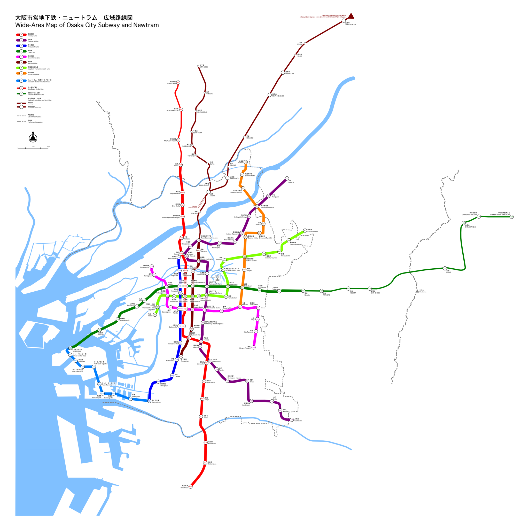
This is a wide-area map that presents Osaka city subway, Newtram and the going direction railways. (It is raster version, so it is low resolution.) ja: 大阪市営地下鉄・ニュートラム・相互乗り入れ路線を表した広域路線図(低解像度ラスタ画像) |
| Date | |
| Source | It is drawn by excl-zoo |
| Author | excl-zoo |
| Permission (Reusing this file) |
PD-self |
| Other versions | image:Wide-Area_Map_of_Osaka_City_Subway.svg |
Licensing edit
| I, the copyright holder of this work, release this work into the public domain. This applies worldwide. In some countries this may not be legally possible; if so: I grant anyone the right to use this work for any purpose, without any conditions, unless such conditions are required by law. |
File history
Click on a date/time to view the file as it appeared at that time.
| Date/Time | Thumbnail | Dimensions | User | Comment | |
|---|---|---|---|---|---|
| current | 13:30, 17 March 2007 | | 3,508 × 3,508 (1.09 MB) | Excl-zoo (talk | contribs) | |
| 13:25, 17 March 2007 |  | 4,209 × 4,209 (1.37 MB) | Excl-zoo (talk | contribs) | ||
| 17:14, 23 December 2006 |  | 2,333 × 2,333 (674 KB) | Excl-zoo (talk | contribs) | ||
| 15:52, 19 July 2006 |  | 2,333 × 2,333 (676 KB) | Excl-zoo (talk | contribs) | ||
| 04:24, 9 July 2006 |  | 3,500 × 3,500 (1.08 MB) | Excl-zoo (talk | contribs) | ||
| 11:45, 8 July 2006 |  | 3,500 × 3,500 (1.08 MB) | Excl-zoo (talk | contribs) | ||
| 05:44, 8 July 2006 |  | 3,500 × 3,500 (1.08 MB) | Excl-zoo (talk | contribs) | ||
| 04:41, 8 July 2006 |  | 3,500 × 3,500 (1.07 MB) | Excl-zoo (talk | contribs) | ||
| 15:22, 7 May 2006 |  | 2,488 × 2,488 (481 KB) | Excl-zoo (talk | contribs) | ||
| 17:57, 22 April 2006 |  | 2,340 × 2,340 (451 KB) | Excl-zoo (talk | contribs) | This is a wide-area map that presents Osaka city subway, Newtram and the going direct railways. It is raster version, so it is low resolution. |
You cannot overwrite this file.
File usage on Commons
The following 4 pages use this file:
File usage on other wikis
The following other wikis use this file:
- Usage on ast.wikipedia.org
- Usage on azb.wikipedia.org
- Usage on bn.wikipedia.org
- Usage on ca.wikipedia.org
- Usage on de.wikipedia.org
- Usage on en.wikipedia.org
- Usage on en.wikivoyage.org
- Usage on es.wikipedia.org
- Usage on eu.wikipedia.org
- Usage on fa.wikipedia.org
- Usage on fi.wikipedia.org
- Usage on fr.wikipedia.org
- Usage on fr.wikivoyage.org
- Usage on he.wikivoyage.org
- Usage on hu.wikipedia.org
- Usage on id.wikipedia.org
- Usage on incubator.wikimedia.org
- Usage on it.wikipedia.org
- Usage on it.wikivoyage.org
- Usage on ja.wikipedia.org
- Usage on jv.wikipedia.org
- Usage on ko.wikipedia.org
- Usage on mn.wikipedia.org
- Usage on nl.wikipedia.org
- Usage on nl.wikivoyage.org
- Usage on pl.wikipedia.org
- Usage on ru.wikipedia.org
- Usage on sat.wikipedia.org
- Usage on sv.wikipedia.org
- Usage on sv.wikivoyage.org
- Usage on th.wikipedia.org
- Usage on tr.wikipedia.org
- Usage on uk.wikipedia.org
- Usage on uz.wikipedia.org
- Usage on www.wikidata.org
- Usage on zh.wikipedia.org