File:Wien - Wotrubakirche, Innenansicht.JPG

Size of this preview: 800 × 533 pixels. Other resolutions: 320 × 213 pixels | 640 × 427 pixels | 1,024 × 683 pixels | 1,280 × 853 pixels | 2,560 × 1,706 pixels | 4,961 × 3,307 pixels.
Original file (4,961 × 3,307 pixels, file size: 9.68 MB, MIME type: image/jpeg)
Captions
Captions
Add a one-line explanation of what this file represents
Summary edit
| Description |
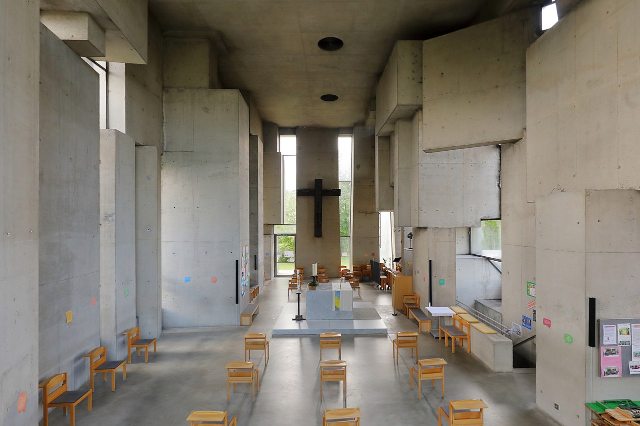
Deutsch: Innenansicht der Wotruba- bzw. Dreifaltigkeitskirche auf dem Georgenberg im Wiener Stadtteil Mauer des 23. Gemeindebezirkes Liesing mit einer aufgelockerten Bestuhlungsanordnung, die der COVID-19-Pandemie geschuldet ist. Das Kreuz an der Altarwand ist ein Bronzeabguss von dem Kreuz, das Wotruba für die Hofkirche in Bruchsal (Deutschland) geschaffen hatte. Bemerkenswert ist die Nachhallzeit des Kirchenraumes von rund zwölf Sekunden. Die Kirche im Stil des Brutalismus wurde auf Initiative von Margarethe Ottillinger (1919–1992) und nach einer Idee des Künstlers Fritz Wotruba (1907–1975) vom Architekten Fritz Gerhard Mayr (* 1931) errichtet. Der Entwurf für die Kirche (152 Betonblöcke mit einen Gesamtgewicht von über 4000 Tonnen, ohne Symmetrie aufeinander geschachtelt, mit schmalen, verschieden hohen Fensteröffnungen) wurde von Wotruba 1964 präsentiert. Wegen großem Widerstand konnte man erst 1974 mit dem Bau beginnen und zwei Jahre später, am 24. Oktober 1976, erfolgte die feierliche Einweihung durch Kardinal Franz König. |
| Date | |
| Source | Own work |
| Author | C.Stadler/Bwag |
| Permission (Reusing this file) |
Deutsch: Hallo, du darfst mein Foto kostenlos nutzen, aber nenne mich bitte als Fotograf, beispielsweise „Foto: C.Stadler/Bwag“ oder © C.Stadler/Bwag; CC-BY-SA-4.0. Auf mehr Angaben bestehe ich nicht - im Gegensatz zu manch anderen, die die Vorgaben der unten angeführten Lizenzierung auf Punkt und Beistrich einfordern. English: Feel free to use my photos, but please mention me as the author like © C.Stadler/Bwag or © C.Stadler/Bwag; CC-BY-SA-4.0 (that's good enough) and if you want send me a message: bwag@gmx.net. |
| Object location | | View this and other nearby images on: OpenStreetMap |
|---|
| Camera location | | View this and other nearby images on: OpenStreetMap |
|---|
Licensing edit
I, the copyright holder of this work, hereby publish it under the following license:
This file is licensed under the Creative Commons Attribution-Share Alike 4.0 International license.
- You are free:
- to share – to copy, distribute and transmit the work
- to remix – to adapt the work
- Under the following conditions:
- attribution – You must give appropriate credit, provide a link to the license, and indicate if changes were made. You may do so in any reasonable manner, but not in any way that suggests the licensor endorses you or your use.
- share alike – If you remix, transform, or build upon the material, you must distribute your contributions under the same or compatible license as the original.
File history
Click on a date/time to view the file as it appeared at that time.
| Date/Time | Thumbnail | Dimensions | User | Comment | |
|---|---|---|---|---|---|
| current | 19:36, 26 May 2020 | | 4,961 × 3,307 (9.68 MB) | Bwag (talk | contribs) | {{Information |Description= {{de|1= Innenansicht der Wotruba- bzw. Dreifaltigkeitskirche auf dem Georgenberg im Wiener Stadtteil Mauer des 23. Gemeindebezirkes Liesing mit einer Bestuhlungsanordnung, die der COVID-19-Pandemie geschuldet ist. Das Kreuz an der Altarwand ist ein Bronzeabguss von dem Kreuz, das Wotruba für die Hofkirche in Bruchsal (Deutschland) geschaffen hatte. Bemerkenswert ist die Nachhallzeit des Kirchenraumes von rund zwölf Sekunden.<!-- https://www.derstandard.at/story/26... |
You cannot overwrite this file.
File usage on Commons
There are no pages that use this file.
File usage on other wikis
The following other wikis use this file:
- Usage on de.wikipedia.org
- Usage on en.wikipedia.org