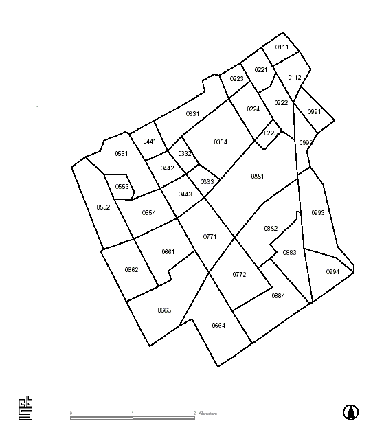
File:WijkenRijswijk.PNG
Size of this preview: 522 × 600 pixels. Other resolutions: 209 × 240 pixels | 559 × 642 pixels.
Original file (559 × 642 pixels, file size: 16 KB, MIME type: image/png)
Captions
Captions
Add a one-line explanation of what this file represents
Summary edit
| Description |
Nederlands: wijken van Rijswijk |
| Date | 27 February 2006 (original upload date) |
| Source | Transferred from nl.wikipedia to Commons. |
| Author | The original uploader was Michiel1972 at Dutch Wikipedia. |
| Permission (Reusing this file) |
STATISTICS NETHERLANDS MAP. |
Licensing edit

|
The copyright holder of this file, Centraal Bureau voor de Statistiek, allows anyone to use it for any purpose, provided that the copyright holder is properly attributed. Redistribution, derivative work, commercial use, and all other use is permitted. |
Attribution:
|
Original upload log edit
The original description page was here. All following user names refer to nl.wikipedia.
- 2006-02-27 14:06 Michiel1972 559×642× (16110 bytes) wijken van Rijswijk {{CBS-wijkkaart}}
File history
Click on a date/time to view the file as it appeared at that time.
| Date/Time | Thumbnail | Dimensions | User | Comment | |
|---|---|---|---|---|---|
| current | 13:38, 13 February 2009 | | 559 × 642 (16 KB) | BotMultichill (talk | contribs) | {{BotMoveToCommons|nl.wikipedia}} {{Information |Description={{nl|wijken van Rijswijk}} |Source=Transferred from [http://nl.wikipedia.org nl.wikipedia] |Date=2006-02-27 (original upload date) |Author=Original uploader was [[:nl:User:Michiel1972|Michiel1 |
You cannot overwrite this file.
File usage on Commons
There are no pages that use this file.
File usage on other wikis
The following other wikis use this file:
- Usage on ca.wikipedia.org
- Usage on nl.wikipedia.org