File:Wildfire raging in Andalucia, Spain.jpg

Original file (4,411 × 2,540 pixels, file size: 1.9 MB, MIME type: image/jpeg)
Captions
Captions
Summary
edit
| Description |
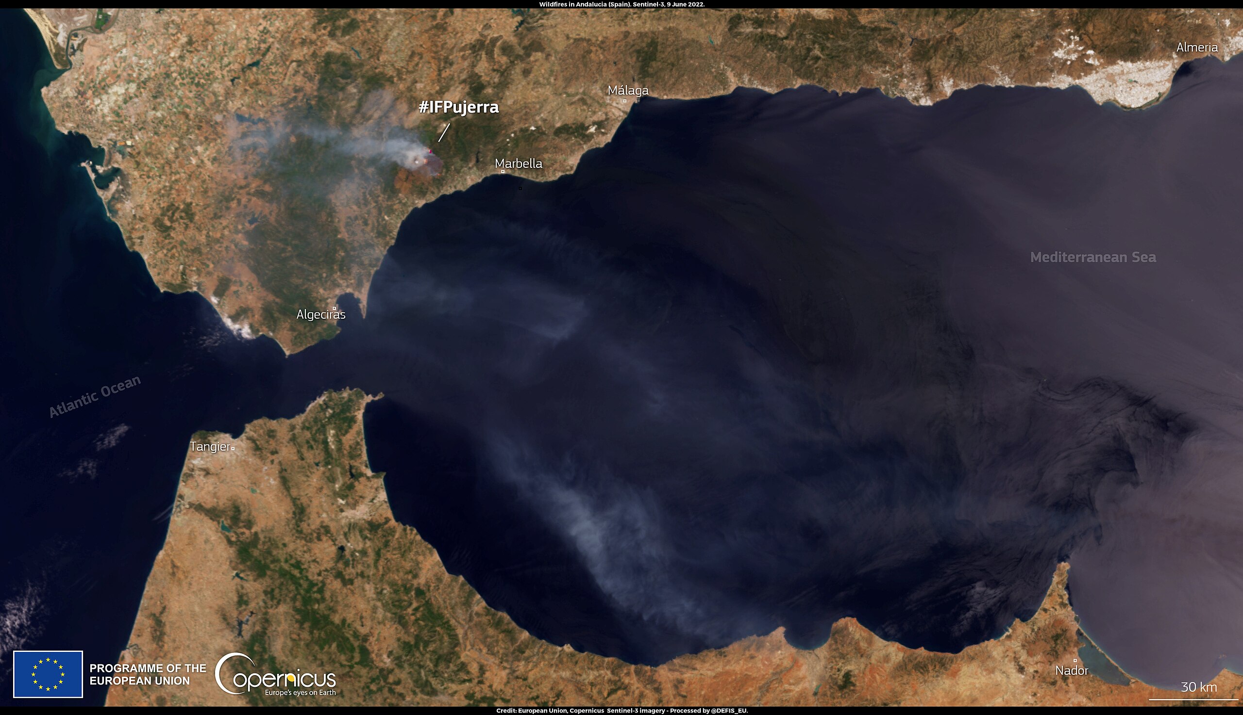
English: A wildfire in the mountains of Andalucia’s Costa del Sol, in southern Spain, has caused the evacuation of 2000 people from the centre of the town of Benahavis. The fire, which flared up on 8 June 2022, has spread due to adverse winds and dry vegetation. The smoke cloud generated by the wildfire is visible in this image, acquired by one of the Copernicus Sentinel-3 satellites on 9 June 2022. As shown in this visualisation published by the Copernicus Emergency Management Service (CEMS), the active wildfire is burning very close to the area of the CEMS Rapid Mapping activation (EMSR545) triggered in September 2021 for the Jubrique wildfire, which left a burn scar of 8,054 hectares. The CEMS Rapid Mapping products provide geospatial information within hours of a service request, in order to support emergency management activities in the immediate aftermath of a disaster. |
| Date | Taken on 9 June 2022 |
| Source | Wildfire raging in Andalucia, Spain |
| Author | European Union, Copernicus Sentinel-3 imagery |
Licensing
edit

|
This image contains data from a satellite in the Copernicus Programme, such as Sentinel-1, Sentinel-2 or Sentinel-3. Attribution is required when using this image.
Attribution: Contains modified Copernicus Sentinel data 2022
The use of Copernicus Sentinel Data is regulated under EU law (Commission Delegated Regulation (EU) No 1159/2013 and Regulation (EU) No 377/2014). Relevant excerpts:
Free access shall be given to GMES dedicated data [...] made available through GMES dissemination platforms [...].
Access to GMES dedicated data [...] shall be given for the purpose of the following use in so far as it is lawful:
GMES dedicated data [...] may be used worldwide without limitations in time.
GMES dedicated data and GMES service information are provided to users without any express or implied warranty, including as regards quality and suitability for any purpose. |
File history
Click on a date/time to view the file as it appeared at that time.
| Date/Time | Thumbnail | Dimensions | User | Comment | |
|---|---|---|---|---|---|
| current | 00:06, 19 August 2023 | | 4,411 × 2,540 (1.9 MB) | OptimusPrimeBot (talk | contribs) | #Spacemedia - Upload of https://www.copernicus.eu/system/files/2022-06/image_day/20220610_WildfireInAndalucia.jpg via Commons:Spacemedia |
You cannot overwrite this file.
File usage on Commons
There are no pages that use this file.