File:Wind Farm PA.jpg

Size of this preview: 800 × 480 pixels. Other resolutions: 320 × 192 pixels | 1,024 × 615 pixels | 1,280 × 768 pixels | 2,681 × 1,609 pixels.
Original file (2,681 × 1,609 pixels, file size: 1.57 MB, MIME type: image/jpeg)
Captions
Captions
Add a one-line explanation of what this file represents
Summary edit
| Description |
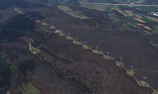
English: Aerial photo of part of the Meyersdale Wind Project along the Allegheny Front in southern Pennsylvania, near Meyersdale in Somerset County.
Photo taken by the original uploader from a glider in flight on April 28, 2007 (looking west). |
| Date | 18 November 2007 (original upload date) |
| Source | Transferred from en.wikipedia to Commons by Teratornis using CommonsHelper. |
| Author | Dhaluza at English Wikipedia |
| Camera location | | View this and other nearby images on: OpenStreetMap |
|---|
Licensing edit
Dhaluza at English Wikipedia, the copyright holder of this work, hereby publishes it under the following licenses:

|
Permission is granted to copy, distribute and/or modify this document under the terms of the GNU Free Documentation License, Version 1.2 or any later version published by the Free Software Foundation; with no Invariant Sections, no Front-Cover Texts, and no Back-Cover Texts. A copy of the license is included in the section entitled GNU Free Documentation License. |
This file is licensed under the Creative Commons Attribution 3.0 Unported license.
Attribution: Dhaluza at English Wikipedia
- You are free:
- to share – to copy, distribute and transmit the work
- to remix – to adapt the work
- Under the following conditions:
- attribution – You must give appropriate credit, provide a link to the license, and indicate if changes were made. You may do so in any reasonable manner, but not in any way that suggests the licensor endorses you or your use.
You may select the license of your choice.
Original upload log edit
The original description page was here. All following user names refer to en.wikipedia.
- 2007-11-18 23:56 Dhaluza 2681×1609× (1644537 bytes) Aerial photo of a [[wind farm]] along the [[Allegheney Front]] in southern [[Pennsylvania]] in the [[United States]]. Photo taken by me from a [[glider]] in flight on [[April 28]], [[2007]].
File history
Click on a date/time to view the file as it appeared at that time.
| Date/Time | Thumbnail | Dimensions | User | Comment | |
|---|---|---|---|---|---|
| current | 02:53, 3 December 2008 | | 2,681 × 1,609 (1.57 MB) | File Upload Bot (Magnus Manske) (talk | contribs) | {{BotMoveToCommons|en.wikipedia}} {{Information |Description={{en|Aerial photo of a en:wind farm along the en:Allegheny Front in southern en:Pennsylvania in the en:United States. Photo taken by me from a en:glider in flight on [ |
You cannot overwrite this file.
File usage on Commons
There are no pages that use this file.
File usage on other wikis
The following other wikis use this file:
- Usage on en.wikipedia.org
- Usage on fr.wikipedia.org
- Usage on ja.wikipedia.org