File:Wordie House, Winter Island (Base F).jpg
Size of this preview: 800 × 518 pixels. Other resolutions: 320 × 207 pixels | 640 × 415 pixels | 1,024 × 663 pixels | 1,280 × 829 pixels.
Original file (1,280 × 829 pixels, file size: 178 KB, MIME type: image/jpeg)
File information
Structured data
Captions
DescriptionWordie House, Winter Island (Base F).jpg |
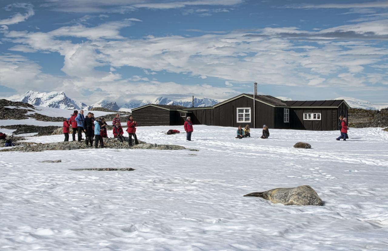
English: Winter Island is an island 0.5 nautical miles (0.9 km) long, lying 0.1 nautical miles (0.2 km) north of Skua Island in the Argentine Islands, Wilhelm Archipelago. Winter Island was named by the British Graham Land Expedition (BGLE), 1934–37, which made this island the site of its winter base during 1935.
In 1947, Falkland Islands Dependencies Survey established a base on Winter Island, Base F (Argentine Islands). The main building ("Wordie House") was erected at the old camp site. The station were relocated to the neighbouring Galindez Island in May 1954 and renamed Faraday Station in 1977. |
||
Date | |||
Source | Flickr: Antarctica 2013: Journey to the Crystal Desert | ||
Author | *christopher* | ||
Permission (Reusing this file) |
This file is licensed under the Creative Commons Attribution 2.0 Generic license.
|
Camera location | 65° 15′ 01.92″ S, 64° 15′ 17.53″ W | View this and other nearby images on: OpenStreetMap | -65.250533; -64.254870 |
---|
File history
Click on a date/time to view the file as it appeared at that time.
Date/Time | Thumbnail | Dimensions | User | Comment | |
---|---|---|---|---|---|
current | 21:29, 15 January 2013 | 1,280 × 829 (178 KB) | Flickr upload bot (talk | contribs) | Uploaded from http://flickr.com/photo/50979393@N00/8369580321 using Flickr upload bot |
You cannot overwrite this file.
File usage on Commons
The following page uses this file:
File usage on other wikis
The following other wikis use this file:
- Usage on ceb.wikipedia.org
- Usage on de.wikipedia.org
- Usage on en.wikipedia.org
- Usage on fi.wikipedia.org
- Usage on no.wikipedia.org
- Usage on pl.wikipedia.org
- Usage on pt.wikipedia.org
- Usage on www.wikidata.org
Metadata
This file contains additional information such as Exif metadata which may have been added by the digital camera, scanner, or software program used to create or digitize it. If the file has been modified from its original state, some details such as the timestamp may not fully reflect those of the original file. The timestamp is only as accurate as the clock in the camera, and it may be completely wrong.
Camera manufacturer | NIKON CORPORATION |
---|---|
Camera model | NIKON D800E |
Author | Christopher Prentiss Michel |
Exposure time | 1/500 sec (0.002) |
F-number | f/11 |
ISO speed rating | 100 |
Date and time of data generation | 11:09, 6 January 2013 |
Lens focal length | 70 mm |
Latitude | 65° 15′ 1.92″ S |
Longitude | 64° 15′ 17.53″ W |
Altitude | 11 meters above sea level |
Usage terms |
|
Orientation | Normal |
Horizontal resolution | 240 dpi |
Vertical resolution | 240 dpi |
Software used | Adobe Photoshop CS6 (Macintosh) |
File change date and time | 23:53, 6 January 2013 |
Exposure Program | Normal program |
Exif version | 2.21 |
Date and time of digitizing | 11:09, 6 January 2013 |
APEX shutter speed | 8.965784 |
APEX aperture | 6.918863 |
APEX exposure bias | 0 |
Maximum land aperture | 4.3 APEX (f/4.44) |
Metering mode | Pattern |
Light source | Unknown |
Flash | Flash did not fire, compulsory flash suppression |
DateTime subseconds | 90 |
DateTimeOriginal subseconds | 90 |
DateTimeDigitized subseconds | 90 |
Color space | Uncalibrated |
Focal plane X resolution | 204.84020996094 |
Focal plane Y resolution | 204.84020996094 |
Focal plane resolution unit | 4 |
Sensing method | One-chip color area sensor |
File source | Digital still camera |
Scene type | A directly photographed image |
Custom image processing | Normal process |
Exposure mode | Auto exposure |
White balance | Auto white balance |
Digital zoom ratio | 1 |
Focal length in 35 mm film | 70 mm |
Scene capture type | Standard |
Scene control | None |
Contrast | Normal |
Saturation | Normal |
Sharpness | Normal |
Subject distance range | Unknown |
GPS time (atomic clock) | 14:09 |
Satellites used for measurement | 10 |
Geodetic survey data used | WGS 84 |
GPS date | 6 January 2013 |
GPS tag version | 0.0.3.2 |
Serial number of camera | 3004054 |
Lens used | 70.0-300.0 mm f/4.5-5.6 |
Rating (out of 5) | 0 |
Date metadata was last modified | 20:53, 6 January 2013 |
Unique ID of original document | A04A1C46F732800BCFB4BB761060853F |
Keywords | Christopher Michel |
Contact information | chris@christophermichel.com
www.ChristopherMichel.com
|