File:World map.pdf

Size of this JPG preview of this PDF file: 693 × 599 pixels. Other resolutions: 278 × 240 pixels | 555 × 480 pixels | 888 × 768 pixels | 1,184 × 1,024 pixels | 1,479 × 1,279 pixels.
Original file (1,479 × 1,279 pixels, file size: 2.61 MB, MIME type: application/pdf)
Captions
Captions
Add a one-line explanation of what this file represents

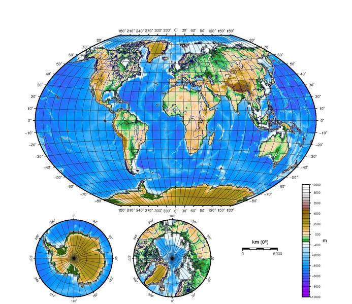
Topography and bathymetry: NOAA/NGDC, ETOPO2
Mapping: Generic Mapping Tools.
Copyright © 2005 David Monniaux

|
Permission is granted to copy, distribute and/or modify this document under the terms of the GNU Free Documentation License, Version 1.2 or any later version published by the Free Software Foundation; with no Invariant Sections, no Front-Cover Texts, and no Back-Cover Texts. A copy of the license is included in the section entitled GNU Free Documentation License. |
| This file is licensed under the Creative Commons Attribution-Share Alike 3.0 Unported license. | ||
| ||
| This licensing tag was added to this file as part of the GFDL licensing update. |
This file is licensed under the Creative Commons Attribution-Share Alike 2.0 Generic license.
- You are free:
- to share – to copy, distribute and transmit the work
- to remix – to adapt the work
- Under the following conditions:
- attribution – You must give appropriate credit, provide a link to the license, and indicate if changes were made. You may do so in any reasonable manner, but not in any way that suggests the licensor endorses you or your use.
- share alike – If you remix, transform, or build upon the material, you must distribute your contributions under the same or compatible license as the original.
This file is licensed under the Creative Commons Attribution-Share Alike 2.0 France license.
- You are free:
- to share – to copy, distribute and transmit the work
- to remix – to adapt the work
- Under the following conditions:
- attribution – You must give appropriate credit, provide a link to the license, and indicate if changes were made. You may do so in any reasonable manner, but not in any way that suggests the licensor endorses you or your use.
- share alike – If you remix, transform, or build upon the material, you must distribute your contributions under the same or compatible license as the original.

ETOPO2="../ETOPO2"
RANGE="-R-180/180/-89/89"
DETAIL="-I4m"

grdsample -Gworld.grd $RANGE $DETAIL $ETOPO2/etopo2.grd
grdlandmask $DETAIL $RANGE -Goceanmask.grd -N0/NaN/NaN/NaN/NaN
grdlandmask $DETAIL $RANGE -Glandmask.grd -NNaN/0/NaN/NaN/NaN
grdmath world.grd oceanmask.grd ADD = ocean.grd
grdmath world.grd landmask.grd ADD = land.grd
RANGE="-R-180/180/-89/89"
PROJECTION="-P -JR0/20 $RANGE"
PALETTE=-Ccontinents_and_oceans.cpt
PALETTEC=-Ccontinents.cpt
PSFILE=World_map.ps
RIVERS="-I1/0.1p/0/0/255"
LAKES="-S180/180/255"

BORDER="-B30g10/10g10"
POLE_BORDER="-B20g10/20g10"
DETAIL="-A100/0/4 -Dl"

COASTLINES="-W.01p/0/0/100"

SOUTH_POLE_PROJECTION="-R-180/180/-90/-60 -JE0/-90/5.5 -P"
NORTH_POLE_PROJECTION="-R-180/180/60/90 -JE0/90/5.5 -P"

gmtset ANNOT_FONT_SIZE_PRIMARY 8 BASEMAP_TYPE plain ANNOT_OFFSET_PRIMARY 0.15c TICK_LENGTH 0.15c GRID_PEN_PRIMARY 0.02p
#BORDERS="-N1/0.1p -N2/0.05p"
pscoast $DETAIL $PROJECTION $COASTLINES $LAKES -K -Y7 > $PSFILE
grdimage $PALETTE $PROJECTION ocean.grd -Q -K -O >> $PSFILE
grdimage $PALETTEC $PROJECTION land.grd -Q -O -K >> $PSFILE
pscoast $BORDERS $RIVERS $COASTLINES $BORDER $PROJECTION -K -O "-Lfx16/-3/0/5000k:km (0\272)" >> $PSFILE

gmtset ANNOT_FONT_SIZE_PRIMARY 6 ANNOT_OFFSET_PRIMARY 0.1c TICK_LENGTH 0.1c
pscoast $DETAIL $SOUTH_POLE_PROJECTION $COASTLINES $LAKES -Y-6.5 -O -K >> $PSFILE
grdimage $PALETTE -J -R ocean.grd -Q -K -O >> $PSFILE
grdimage $PALETTEC -J -R -O -K -Q land.grd >> $PSFILE
pscoast $BORDERS $RIVERS $COASTLINES $BORDER -J -R -K -O >> $PSFILE

pscoast $DETAIL $NORTH_POLE_PROJECTION $COASTLINES $LAKES -X7 -K -O >> $PSFILE
grdimage $PALETTE -J -R ocean.grd -Q -K -O >> $PSFILE
grdimage $PALETTEC -J -R -O -K -Q land.grd >> $PSFILE
pscoast $BORDERS $RIVERS $COASTLINES $BORDER -J -R -O -K >> $PSFILE

gmtset ANNOT_FONT_SIZE_SECONDARY 8 LABEL_FONT_SIZE 10 HEADER_FONT_SIZE 10
psscale -D12/4/8/0.5 $PALETTE -B:m: -L -O $FORMAT >>$PSFILE

GS_OPTIONS="-dTextAlphaBits=4 -dGraphicsAlphaBits=4" pstopnm -portrait -xsize=2000 -xborder=0 -yborder=0 -stdout -ppm $PSFILE | pnmtopng > World_map.png
continents.cpt:
#	cpt file created by: makecpt -Z -Cglobe
#COLOR_MODEL = RGB
#
-1000	51	102	0	0	51	102	0
0	51	102	0	100	51	204	102
100	51	204	102	200	187	228	146
200	187	228	146	500	255	220	185
500	255	220	185	1000	243	202	137 L
1000	243	202	137	1500	230	184	88
1500	230	184	88	2000	217	166	39
2000	217	166	39	2500	168	154	31
2500	168	154	31	3000	164	144	25 L
3000	164	144	25	3500	162	134	19
3500	162	134	19	4000	159	123	13
4000	159	123	13	4500	156	113	7
4500	156	113	7	5000	153	102	0 L
5000	153	102	0	5500	162	89	89
5500	162	89	89	6000	178	118	118
6000	178	118	118	6500	183	147	147
6500	183	147	147	7000	194	176	176 L
7000	194	176	176	7500	204	204	204
7500	204	204	204	8000	229	229	229
8000	229	229	229	8500	242	242	242
8500	242	242	242	9000	255	255	255 L
9000	255	255	255	9500	255	255	255
9500	255	255	255	10000	255	255	255 U
B	0	0	0
F	255	255	255
N	128	128	128
continents_and_oceans.cpt:
#	cpt file created by: makecpt -Z -Cglobe
#COLOR_MODEL = RGB
#
-10000	153	0	255	-9500	153	0	255 L
-9500	153	0	255	-9000	153	0	255
-9000	153	0	255	-8500	153	0	255
-8500	136	17	255	-8000	136	17	255
-8000	119	34	255	-7500	119	34	255 L
-7500	102	51	255	-7000	102	51	255
-7000	85	68	255	-6500	85	68	255
-6500	68	85	255	-6000	68	85	255
-6000	51	102	255	-5500	51	102	255 L
-5500	34	119	255	-5000	34	119	255
-5000	17	136	255	-4500	17	136	255
-4500	0	153	255	-4000	0	153	255
-4000	27	164	255	-3500	27	164	255 L
-3500	54	175	255	-3000	54	175	255
-3000	81	186	255	-2500	81	186	255
-2500	108	197	255	-2000	108	197	255
-2000	134	208	255	-1500	134	208	255 L
-1500	161	219	255	-1000	161	219	255
-1000	188	230	255	-500	188	230	255
-500	215	241	255	-200	215	241	255
-200	241	252	255	0	241	252	255 L
0	51	102	0	100	51	204	102
100	51	204	102	200	187	228	146
200	187	228	146	500	255	220	185
500	255	220	185	1000	243	202	137 L
1000	243	202	137	1500	230	184	88
1500	230	184	88	2000	217	166	39
2000	217	166	39	2500	168	154	31
2500	168	154	31	3000	164	144	25 L
3000	164	144	25	3500	162	134	19
3500	162	134	19	4000	159	123	13
4000	159	123	13	4500	156	113	7
4500	156	113	7	5000	153	102	0 L
5000	153	102	0	5500	162	89	89
5500	162	89	89	6000	178	118	118
6000	178	118	118	6500	183	147	147
6500	183	147	147	7000	194	176	176 L
7000	194	176	176	7500	204	204	204
7500	204	204	204	8000	229	229	229
8000	229	229	229	8500	242	242	242
8500	242	242	242	9000	255	255	255 L
9000	255	255	255	9500	255	255	255
9500	255	255	255	10000	255	255	255 U
B	0	0	0
F	255	255	255
N	128	128	128
File history
Click on a date/time to view the file as it appeared at that time.
| Date/Time | Thumbnail | Dimensions | User | Comment | |
|---|---|---|---|---|---|
| current | 20:25, 28 May 2005 |  | 1,479 × 1,279 (2.61 MB) | David.Monniaux (talk | contribs) | thumb|right|300px '''Topography and bathymetry:''' en:NOAA/NGDC, [http://www.ngdc.noaa.gov/mgg/fliers/01mgg04.html ETOPO2]<br> '''Mapping:''' ''Generic Mapping Tools''.<br> {{subst:DMonniaux}} |
You cannot overwrite this file.
File usage on Commons
There are no pages that use this file.