File:World vehicles per capita.svg

Size of this PNG preview of this SVG file: 800 × 406 pixels. Other resolutions: 320 × 162 pixels | 640 × 325 pixels | 1,024 × 520 pixels | 1,280 × 650 pixels | 2,560 × 1,299 pixels | 940 × 477 pixels.
Original file (SVG file, nominally 940 × 477 pixels, file size: 1.37 MB)
Captions
Captions
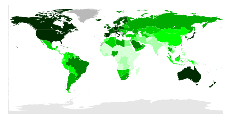
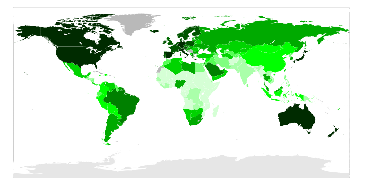
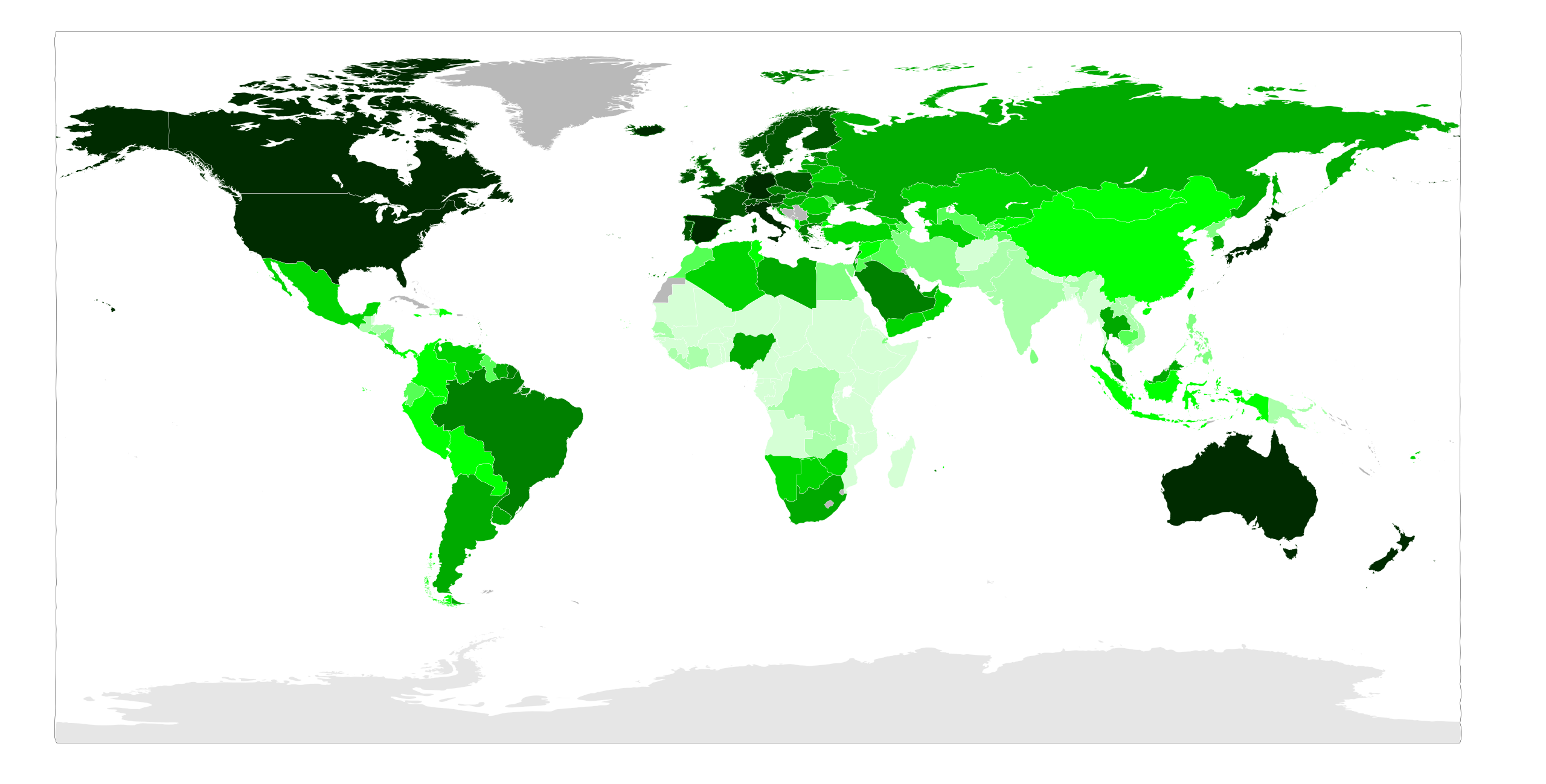
Map showing vehicles per thousand people in different countries
Summary edit
| Description |
English: Map showing vehicles per thousand people in different countries.
601+
501–600
301–500
151–300
101–150
61–100
41–60
21–40
11–20
0–10 |
| Date | April 1st, 2009. Updated 2011. Age of data varies. |
| Source | self-made - An SVG version of previous PNG map. Used blank World Map here. |
| Author | TastyCakes (talk) |
| Other versions |
 |
Licensing edit
| I, the copyright holder of this work, release this work into the public domain. This applies worldwide. In some countries this may not be legally possible; if so: I grant anyone the right to use this work for any purpose, without any conditions, unless such conditions are required by law. |
| Annotations | This image is annotated: View the annotations at Commons |
File history
Click on a date/time to view the file as it appeared at that time.
| Date/Time | Thumbnail | Dimensions | User | Comment | |
|---|---|---|---|---|---|
| current | 10:56, 28 January 2019 | | 940 × 477 (1.37 MB) | Juniorpetjua (talk | contribs) | Updated Brazil (71 million motor vehicles) - https://www.denatran.gov.br/estatistica/635-frota-2018 |
| 16:21, 2 May 2017 |  | 940 × 477 (1.37 MB) | Jamie Tubers (talk | contribs) | updated some countries | |
| 15:28, 18 October 2012 |  | 940 × 477 (1.37 MB) | Werran (talk | contribs) | 2011 updates | |
| 02:44, 2 April 2008 |  | 940 × 477 (1.35 MB) | TastyCakes (talk | contribs) | {{Information |Description= Vehicles per thousand people. {{legend|#002b00|601+}} {{legend|#005500|501-600}} {{legend|#008000|301-500}} {{legend|#00aa00|151-300}} {{legend|#00d400|101-150}} {{legend|#00ff00|61-100}} {{legend|#55ff55|41-60}} {{legend|#80ff |
You cannot overwrite this file.
File usage on Commons
The following 7 pages use this file:
- User:Chumwa/OgreBot/Potential transport maps/2017 May 1-10
- User:Chumwa/OgreBot/Potential transport maps/2019 January 21-31
- User:Chumwa/OgreBot/Transport Maps/2017 May 1-10
- User:Chumwa/OgreBot/Transport Maps/2019 January 21-31
- User:Chumwa/OgreBot/Travel and communication maps/2017 May 1-10
- User:Chumwa/OgreBot/Travel and communication maps/2019 January 21-31
- File:World vehicles per capita.png
File usage on other wikis
The following other wikis use this file:
- Usage on ar.wikipedia.org
- Usage on arz.wikipedia.org
- Usage on az.wikipedia.org
- Usage on ba.wikipedia.org
- Usage on be-tarask.wikipedia.org
- Usage on be.wikipedia.org
- Usage on br.wikipedia.org
- Usage on cs.wikipedia.org
- Usage on cu.wikipedia.org
- Usage on cy.wikipedia.org
- Usage on de.wikipedia.org
- Usage on el.wikipedia.org
- Usage on en.wikipedia.org
- Usage on es.wikipedia.org
- Usage on fa.wikipedia.org
- Usage on fo.wikipedia.org
- Usage on fr.wikipedia.org
- Usage on gu.wikipedia.org
- Usage on hi.wikipedia.org
- Usage on hu.wikipedia.org
- Usage on it.wikipedia.org
- Usage on ja.wikipedia.org
- Usage on kk.wikipedia.org
- Usage on kn.wikipedia.org
- Usage on lv.wikipedia.org
- Usage on mk.wikipedia.org
- Usage on my.wikipedia.org
- Usage on new.wikipedia.org
- Usage on os.wikipedia.org
- Usage on pnb.wikipedia.org
- Usage on pt.wikipedia.org
- Usage on ru.wikipedia.org
- Usage on si.wikipedia.org
- Usage on sk.wikipedia.org
- Usage on sv.wikipedia.org
View more global usage of this file.