File:Yakima River Canyon (30692979635).jpg
Original file (2,550 × 3,300 pixels, file size: 2.06 MB, MIME type: image/jpeg)
Captions
Captions
Summary edit
.jpg&action=edit§ion=1)
| Description |
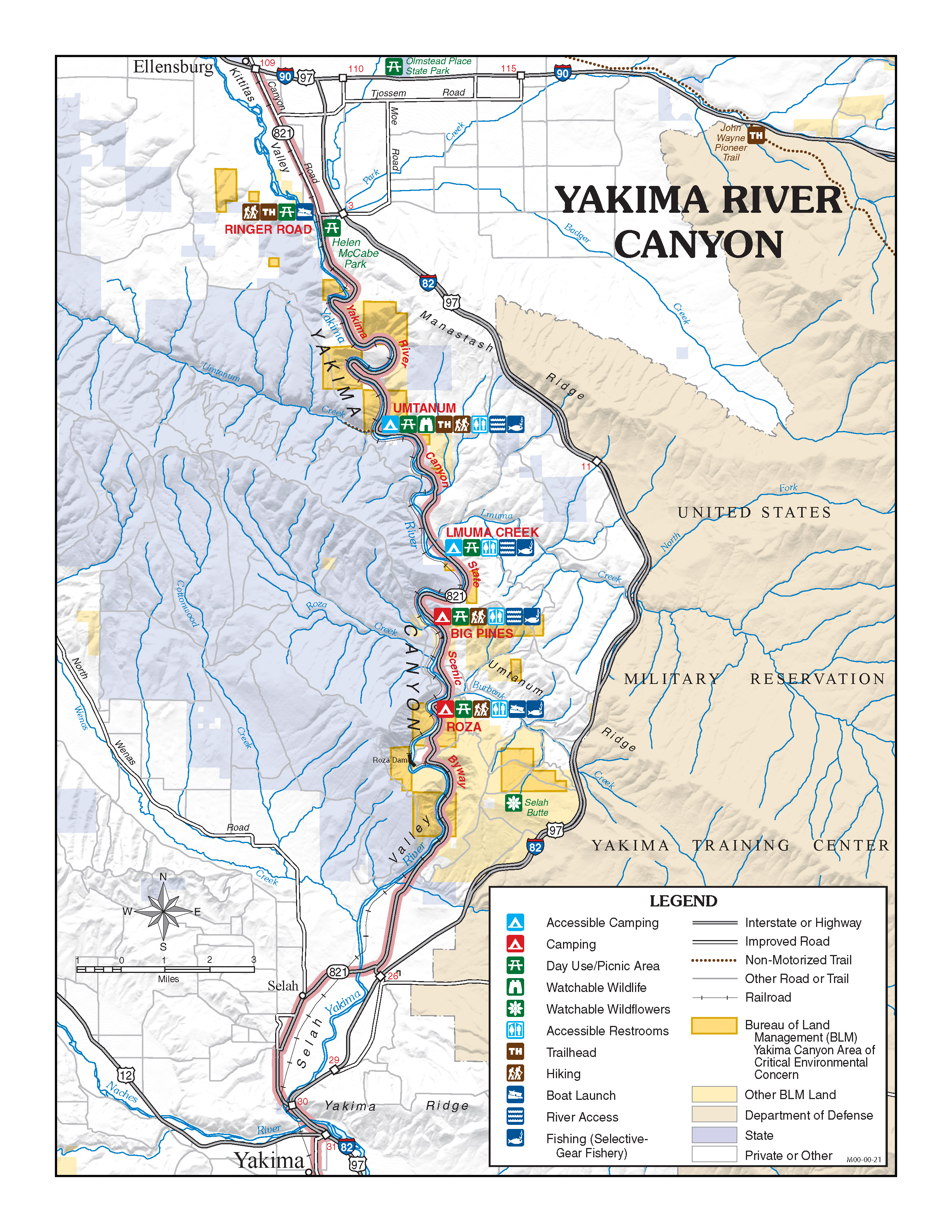
Welcome to the Yakima River Canyon, where Highway 821 parallels the gentle Yakima River for 27 miles, through massive basalt cliffs and rolling desert hills. Follow this scenic pathway for glimpses of rich wildlife and plant communities, echoes of a historical past and many opportunities for recreational enjoyment. This canyon has been designated as a state scenic route and offers excellent wildlife viewing, fishing in a Blue Ribbon trout stream, family river rafting and camping. BLM manages over 9000 acres in the Yakima River Canyon area, including four developed river access sites. Follow the meandering river, as it slices between basalt cliffs formed by centuries-old upheavals. It's thought that Yakima River predates those stony ramparts, once flowing across a relatively flat landscape. As rock ridges rose, river erosion equaled the walls which once formed part of one of the largest lava fields in the world, said to have covered 200,000 square miles in Washington, Oregon and Idaho. <a href="https://www.youtube.com/watch?v=mZm6g7EHAGA" rel="nofollow">www.youtube.com/watch?v=mZm6g7EHAGA</a> For more information contact: Spokane District Office 1103 N. Fancher Road Spokane, WA 99212 509-536-1200 BLM_OR_SP_Mail@blm.gov |
| Date | |
| Source | Yakima River Canyon |
| Author | Bureau of Land Management Oregon and Washington from Portland, America |
Licensing edit
.jpg&action=edit§ion=2)
- You are free:
- to share – to copy, distribute and transmit the work
- to remix – to adapt the work
- Under the following conditions:
- attribution – You must give appropriate credit, provide a link to the license, and indicate if changes were made. You may do so in any reasonable manner, but not in any way that suggests the licensor endorses you or your use.
| This image was originally posted to Flickr by BLMOregon at https://flickr.com/photos/50169152@N06/30692979635 (archive). It was reviewed on 13 May 2018 by FlickreviewR 2 and was confirmed to be licensed under the terms of the cc-by-2.0. |
| This image is a work of a Bureau of Land Management* employee, taken or made as part of that person's official duties. As a work of the U.S. federal government, the image is in the public domain in the United States. *or predecessor organization |
File history
Click on a date/time to view the file as it appeared at that time.
| Date/Time | Thumbnail | Dimensions | User | Comment | |
|---|---|---|---|---|---|
| current | 22:18, 13 May 2018 | | 2,550 × 3,300 (2.06 MB) | OceanAtoll (talk | contribs) | Transferred from Flickr via #flickr2commons |
You cannot overwrite this file.
File usage on Commons
There are no pages that use this file.
.jpg&oldid=744142532)