File:Yaphank-map.png
No higher resolution available.
Yaphank-map.png (575 × 425 pixels, file size: 43 KB, MIME type: image/png)
Captions
Captions
Add a one-line explanation of what this file represents
Summary
edit
| Description | |
| Date | |
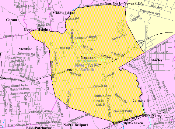
| Source | http://factfinder.census.gov |
| Author | United States Census Bureau |
| Permission (Reusing this file) |
Public domain |
Licensing
edit
This image or file is a work of a United States Census Bureau employee, taken or made as part of that person's official duties. As a work of the U.S. federal government, the image is in the public domain.
|
 |
Original upload log
edit
The original description page was here. All following user names refer to en.wikipedia.
- 2007-11-21 01:48 Americasroof 575×425× (56111 bytes) [[Yaphank, New York]] map from U.S. Census
File history
Click on a date/time to view the file as it appeared at that time.
| Date/Time | Thumbnail | Dimensions | User | Comment | |
|---|---|---|---|---|---|
| current | 14:03, 9 November 2013 | | 575 × 425 (43 KB) | McPot (talk | contribs) | User requested conversion to PNG. Bot: Converting file to superior PNG file. (Uploaded new version of file using Wiki.java) |
You cannot overwrite this file.
File usage on Commons
The following 3 pages use this file:
File usage on other wikis
The following other wikis use this file:
- Usage on ar.wikipedia.org
- Usage on azb.wikipedia.org
- Usage on ca.wikipedia.org
- Usage on en.wikipedia.org
- Usage on es.wikipedia.org
- Usage on eu.wikipedia.org
- Usage on fa.wikipedia.org
- Usage on it.wikipedia.org
- Usage on sh.wikipedia.org
- Usage on tt.wikipedia.org
- Usage on www.wikidata.org