File:Yom Kippur War map-2.png

Size of this preview: 399 × 600 pixels. Other resolutions: 159 × 240 pixels | 401 × 603 pixels.
Original file (401 × 603 pixels, file size: 65 KB, MIME type: image/png)
Captions
Captions
Add a one-line explanation of what this file represents
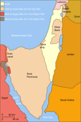
| Description | Self-made line drawing of a map Israel's ceasefire lines with its neighboring countries after its establishment (1949), after the Six Day War (June 1967) and the last front line after Yom Kippur War (late October 1973). After the latter. Author: User:Raul654 Source of line drawing: Now-deleted image Image:Jom kippur war.jpg, which was originally uploaded to the polish Wikipedia at http://pl.wikipedia.org/wiki/Grafika:Jom_kippur_war.jpg -- Ministerstwo Spraw Zagranicznych Izraela, za zgodÄ… Ambasady Izraela w Polsce. -- Ministry of Foreign Affairs of Israel, with the permission of Israel Embassy in Poland |
| Date | (UTC) |
| Source | |
| Author |
|
| This is a retouched picture, which means that it has been digitally altered from its original version. Modifications: Israeli territory before the Six day war is the same as after. The original can be viewed here: Yom Kippur War map.svg:
|
I, the copyright holder of this work, hereby publish it under the following license:
This file is licensed under the Creative Commons Attribution-Share Alike 2.5 Generic license.
- You are free:
- to share – to copy, distribute and transmit the work
- to remix – to adapt the work
- Under the following conditions:
- attribution – You must give appropriate credit, provide a link to the license, and indicate if changes were made. You may do so in any reasonable manner, but not in any way that suggests the licensor endorses you or your use.
- share alike – If you remix, transform, or build upon the material, you must distribute your contributions under the same or compatible license as the original.
Original upload log edit
This image is a derivative work of the following images:
- File:Yom_Kippur_War_map.svg licensed with Cc-by-sa-2.5
- 2010-07-03T14:35:39Z ChrisO 400x602 (44519 Bytes)
- 2010-02-20T12:52:00Z Hohum 400x602 (44263 Bytes) Added border lines.
- 2009-05-31T13:42:58Z Hohum 400x602 (46716 Bytes) Fixed Golan Heights colour.
- 2009-05-31T13:39:18Z Hohum 400x602 (46739 Bytes) Adjusted colours to be less garish, more map-like.
- 2009-04-09T11:32:56Z Kordas 400x602 (46093 Bytes) colours fixed
- 2008-05-15T23:23:08Z Kordas 400x602 (46918 Bytes) Updated version (Added "West Bank" and seas names' in white)
- 2007-10-03T04:11:40Z Andrew Hampe 400x602 (47298 Bytes) Removed line referencing external jpeg image.
- 2007-10-03T03:58:34Z Raul654 400x602 (46347 Bytes) Standard svg
- 2007-10-03T03:55:12Z Raul654 400x602 (46347 Bytes) Self-made line drawing of a map of Israel's territories before and after the Yom Kippur War. Source of line drawing: Now-deleted image [[:Image:Jom kippur war.jpg]] {{cc-by-sa}}
Uploaded with derivativeFX
File history
Click on a date/time to view the file as it appeared at that time.
| Date/Time | Thumbnail | Dimensions | User | Comment | |
|---|---|---|---|---|---|
| current | 11:03, 2 December 2010 | | 401 × 603 (65 KB) | Supreme Deliciousness (talk | contribs) | {{Information |Description=Self-made line drawing of a map of Israel's territories before and after the Yom Kippur War. Author: User:Raul654 Source of line drawing: Now-deleted image Image:Jom kippur war.jpg, which was originally uploaded to the |
You cannot overwrite this file.
File usage on Commons
There are no pages that use this file.
File usage on other wikis
The following other wikis use this file:
- Usage on ca.wikipedia.org
- Guerra del Yom Kippur
- Resolució 446 del Consell de Seguretat de les Nacions Unides
- Resolució 452 del Consell de Seguretat de les Nacions Unides
- Resolució 471 del Consell de Seguretat de les Nacions Unides
- Resolució 605 del Consell de Seguretat de les Nacions Unides
- Resolució 636 del Consell de Seguretat de les Nacions Unides
- Usage on da.wikipedia.org
- Usage on et.wikipedia.org
- Usage on it.wikipedia.org
- Usage on it.wikibooks.org
- Usage on jv.wikipedia.org
- Usage on nl.wikipedia.org
- Usage on pt.wikipedia.org
- Usage on sh.wikipedia.org
- Usage on vi.wikipedia.org
- Usage on www.wikidata.org