File:Yugoslavia 1998 ethnic map es.svg

Size of this PNG preview of this SVG file: 800 × 579 pixels. Other resolutions: 320 × 232 pixels | 640 × 464 pixels | 1,024 × 742 pixels | 1,280 × 927 pixels | 2,560 × 1,854 pixels | 1,734 × 1,256 pixels.
Original file (SVG file, nominally 1,734 × 1,256 pixels, file size: 1.42 MB)
Captions
Captions
Add a one-line explanation of what this file represents
Summary edit
| Description |
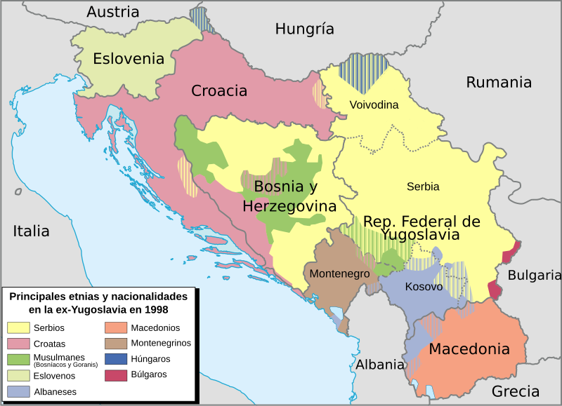
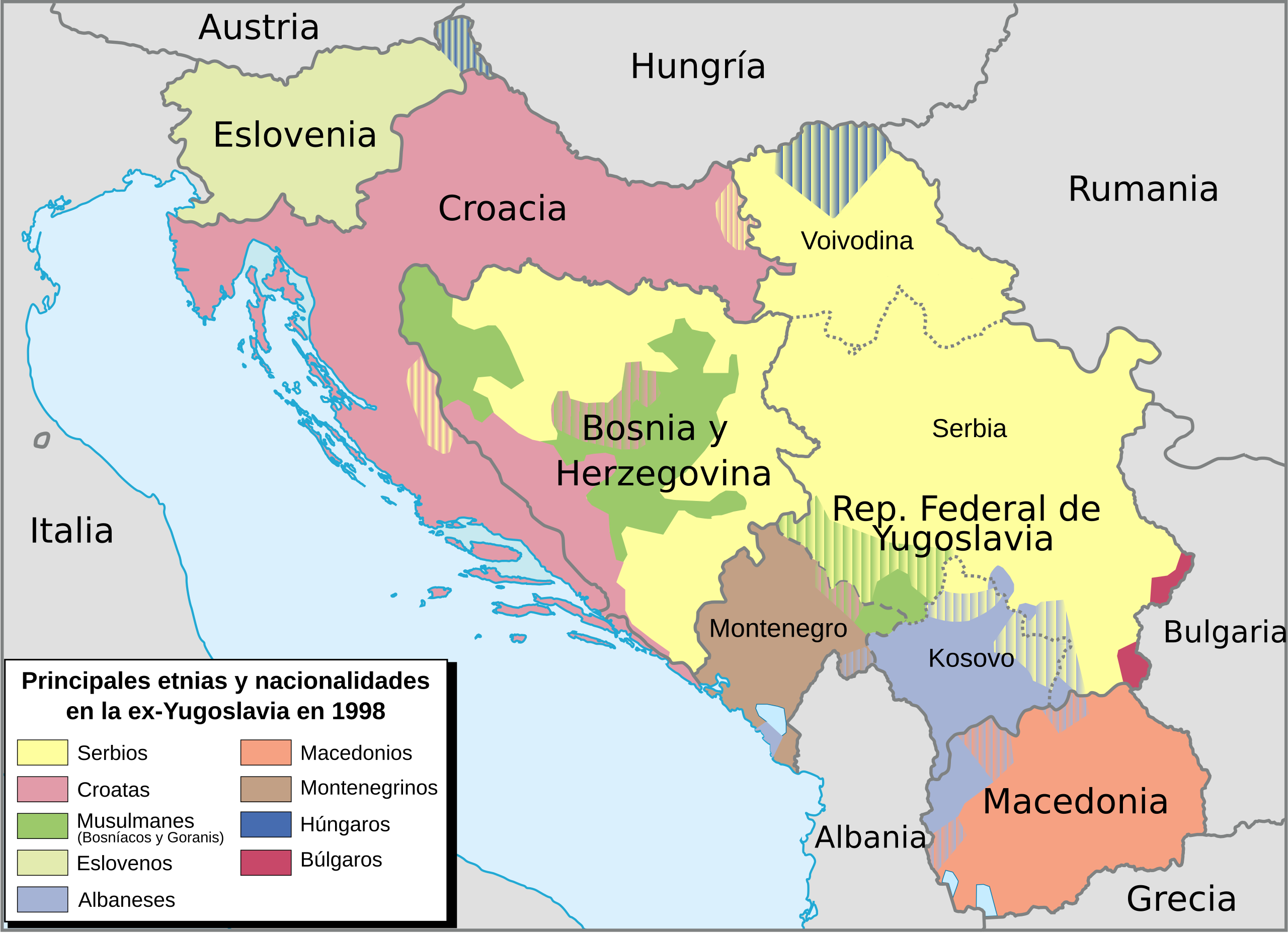
Français : Mapa de etnias y nacionalidadesen en la ex-Yugoslavia en 1998
English: Ex-Yugoslavia ethnic map in 1998 |
| Date | 9/03/2008 |
| Source | Le Monde Diplomatique (2001) + Image:Yugoslavia map norwegian.svg by User:Stianbh |
| Author | historicair 23:04, 16 July 2007 (UTC). Translated to Spanish by B1mbo |
| Other versions |
|


|
This SVG file contains embedded text that can be translated into your language, using any capable SVG editor, text editor or the SVG Translate tool. For more information see: About translating SVG files. |
Licensing edit
I, the copyright holder of this work, hereby publish it under the following licenses:

|
Permission is granted to copy, distribute and/or modify this document under the terms of the GNU Free Documentation License, Version 1.2 or any later version published by the Free Software Foundation; with no Invariant Sections, no Front-Cover Texts, and no Back-Cover Texts. A copy of the license is included in the section entitled GNU Free Documentation License. |
This file is licensed under the Creative Commons Attribution-Share Alike 4.0 International, 3.0 Unported, 2.5 Generic, 2.0 Generic and 1.0 Generic license.
- You are free:
- to share – to copy, distribute and transmit the work
- to remix – to adapt the work
- Under the following conditions:
- attribution – You must give appropriate credit, provide a link to the license, and indicate if changes were made. You may do so in any reasonable manner, but not in any way that suggests the licensor endorses you or your use.
- share alike – If you remix, transform, or build upon the material, you must distribute your contributions under the same or compatible license as the original.
You may select the license of your choice.
File history
Click on a date/time to view the file as it appeared at that time.
| Date/Time | Thumbnail | Dimensions | User | Comment | |
|---|---|---|---|---|---|
| current | 12:19, 6 March 2017 | | 1,734 × 1,256 (1.42 MB) | Rowanwindwhistler (talk | contribs) | Fake text added |
| 11:23, 6 May 2011 |  | 1,734 × 1,256 (1.26 MB) | 123iti (talk | contribs) | factual accuracy | |
| 18:05, 16 August 2008 |  | 1,734 × 1,256 (607 KB) | B1mbo (talk | contribs) | República Federal de Yugoslavia en vez de Serbia, Montenegro y (Kosovo) | |
| 17:46, 9 March 2008 |  | 1,734 × 1,256 (567 KB) | B1mbo (talk | contribs) | {{Information |Description={{fr|Mapa de etnias y nacionalidadesen en la ex-Yugoslavia en 1998}} {{en|Ex-Yugoslavia ethnic map in 1998}} |Source=Le Monde Diplomatique (2001) + Image:Yugoslavia map norwegian.svg by User:Stianbh |Date=9/03/2008 |Aut |
You cannot overwrite this file.
File usage on Commons
The following 3 pages use this file:
File usage on other wikis
The following other wikis use this file:
- Usage on es.wikipedia.org
- Usage on tr.wikipedia.org