File:Zürich - Oerlikon - Gygerkarte 1667.jpg

Size of this preview: 758 × 600 pixels. Other resolutions: 303 × 240 pixels | 607 × 480 pixels.
Original file (800 × 633 pixels, file size: 379 KB, MIME type: image/jpeg)
Captions
Captions
Add a one-line explanation of what this file represents
Summary edit
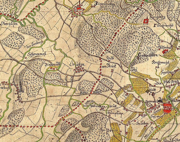
| Description |
Deutsch: Hans Conrad Gyger : Zürich - Oerlikon und angrenzende heutige Stadtquartiere auf dem «Gygerplan» (1667) «Karte des Kantons Zürich aus dem Jahr 1667 in 56 Blättern von Hans Conrad Gyger». Der Ausschnitt aus der Kantonskarte von Hans Conrad Gyger zeigt Oerlikon (Bildmitte rechts), Seebach (links), oben die Propstei-Ziegelhütte bei Schwamendingen-Stettbach-Dübendorf, ebenso das Kloster St. Martin (oben rechts) und Oberstrass (rechts). Am unteren Bildrand findet sich der Käferberg und rechts von Stettbach der Zürichberg-Adlisberg mit Teilen des Stadtquartiers Fluntern. Die roten Punkte markieren die Vogteigrenzen; die Grenze des Stadtbanns, die damals südlich des heutigen Schaffhauserplatzes (ganz rechts) verlief, ist nicht eingezeichnet. Beschreibung von der Website des Ortsgeschichtlichen Vereins Oerlikon, präzisisert und ergänzt um weitere Bezugspunkte. |
|||||||||||||||||
| Date | ||||||||||||||||||
| Source | Ortsgeschichtlicher Verein Oerlikon | |||||||||||||||||
| Author |
|
|||||||||||||||||

Licensing edit
|
This work is in the public domain in its country of origin and other countries and areas where the copyright term is the author's life plus 100 years or fewer. | |
| This file has been identified as being free of known restrictions under copyright law, including all related and neighboring rights. | |
File history
Click on a date/time to view the file as it appeared at that time.
| Date/Time | Thumbnail | Dimensions | User | Comment | |
|---|---|---|---|---|---|
| current | 02:24, 20 September 2008 | | 800 × 633 (379 KB) | Roland zh (talk | contribs) | == Summary == {{Information |Description={{de|Hans Conrad Gyger : Zürich-Oerlikon auf dem «Gygerplan» (1667)<br>'''«Karte des Kantons Zürich aus dem Jahr 1667 in 56 Blättern von Hans Conrad |
You cannot overwrite this file.
File usage on Commons
There are no pages that use this file.
File usage on other wikis
The following other wikis use this file:
- Usage on cs.wikipedia.org
- Usage on de.wikipedia.org
- Usage on ru.wikipedia.org
- Usage on sk.wikipedia.org