File:Zapporthorn Spherical Panorama.jpg

Size of this preview: 800 × 400 pixels. Other resolutions: 320 × 160 pixels | 640 × 320 pixels | 1,024 × 512 pixels | 1,280 × 640 pixels | 2,560 × 1,280 pixels | 20,992 × 10,496 pixels.
Original file (20,992 × 10,496 pixels, file size: 38.03 MB, MIME type: image/jpeg)
Captions
Captions
Add a one-line explanation of what this file represents
Titel: Piz {} Spherical Panorama.jpg
Summary edit
| Warning | The original file is very high-resolution. It might not load properly or could cause your browser to freeze when opened at full size. |
|---|
| Description |
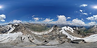
English: Spherical Panorama from Zapporthorn (Mesocco, Grisons, Switzerland). Adula Alps with Rheinwaldhorn.
Deutsch: Kugelpanorama vom Zapporthorn (Mesocco, Graubünden, Schweiz) mit Rheinwaldhorn - Adula-Alpen und Güferhorn. Blick auch ins obere Calancatal im Süden und die Berge dort (La Guardia, I Rodond), dazwischen wegen der hohen Qualität des Fotos auch ein Fernblick in die Tessiner Berge im Westen.
Rumantsch: Panorama sferic digl Zapporthorn (Mesocco, Grischun, Svizra). Adula.
Italiano: Panorama sferico dal Zapporthorn (Mesocco, Grigioni, Svizzera). Rheinwaldhorn - Alpi dell'Adula, Cima Rossa, Val Calanca. |
||
| Date | |||
| Source |
Own work
|
||
| Author | Capricorn4049 | ||
| Permission (Reusing this file) |
|
||
| Other versions |
|

| Camera location | | View this and other nearby images on: OpenStreetMap |
|---|
| 360° | View in 360° panoramic viewer
|
|---|
|
|
Further spherical panoramas can be found here. |

Licensing edit
I, the copyright holder of this work, hereby publish it under the following license:
This file is licensed under the Creative Commons Attribution-Share Alike 4.0 International license.
- You are free:
- to share – to copy, distribute and transmit the work
- to remix – to adapt the work
- Under the following conditions:
- attribution – You must give appropriate credit, provide a link to the license, and indicate if changes were made. You may do so in any reasonable manner, but not in any way that suggests the licensor endorses you or your use.
- share alike – If you remix, transform, or build upon the material, you must distribute your contributions under the same or compatible license as the original.
| Annotations | This image is annotated: View the annotations at Commons |
File history
Click on a date/time to view the file as it appeared at that time.
| Date/Time | Thumbnail | Dimensions | User | Comment | |
|---|---|---|---|---|---|
| current | 20:42, 1 July 2018 | | 20,992 × 10,496 (38.03 MB) | Capricorn4049 (talk | contribs) | User created page with UploadWizard |
You cannot overwrite this file.
File usage on Commons
The following page uses this file:
File usage on other wikis
The following other wikis use this file:
- Usage on de.wikipedia.org
- Usage on www.wikidata.org