File:Zealandia-Continent map fr.svg

Size of this PNG preview of this SVG file: 548 × 599 pixels. Other resolutions: 219 × 240 pixels | 439 × 480 pixels | 702 × 768 pixels | 937 × 1,024 pixels | 1,873 × 2,048 pixels | 794 × 868 pixels.
Original file (SVG file, nominally 794 × 868 pixels, file size: 339 KB)
Captions
Captions
Add a one-line explanation of what this file represents
Summary edit
| Description |
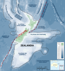
English: Map of the Zealandia (continent). Français : Carte du continent de Zealandia. |
||
| Date | (UTC) | ||
| Source |
This file was derived from: Zealandia-Continent map en.svg:  |
||
| Author |
|
||
| Other versions | |||
| Attribution (required by the license) | © Sémhur / Wikimedia Commons / | ||
| SVG | W3C-validity not checked.
|

| Camera location | | View this and other nearby images on: OpenStreetMap |
|---|
Licensing edit
I, the copyright holder of this work, hereby publish it under the following licenses:
| Copyleft: This work of art is free; you can redistribute it and/or modify it according to terms of the Free Art License. You will find a specimen of this license on the Copyleft Attitude site as well as on other sites. |
This file is licensed under the Creative Commons Attribution-Share Alike 4.0 International, 3.0 Unported, 2.5 Generic, 2.0 Generic and 1.0 Generic license.
- You are free:
- to share – to copy, distribute and transmit the work
- to remix – to adapt the work
- Under the following conditions:
- attribution – You must give appropriate credit, provide a link to the license, and indicate if changes were made. You may do so in any reasonable manner, but not in any way that suggests the licensor endorses you or your use.
- share alike – If you remix, transform, or build upon the material, you must distribute your contributions under the same or compatible license as the original.
You may select the license of your choice.
Original upload log edit
This image is a derivative work of the following images:
- File:Zealandia-Continent_map_en.svg licensed with Cc-by-sa-3.0
- 2010-07-19T22:37:40Z Beao 789x864 (334477 Bytes) Removed border.
- 2009-06-01T11:59:23Z Alexrk 797x871 (383806 Bytes) Removed Grid
- 2008-01-20T14:19:36Z Alexrk 797x871 (389316 Bytes)
- 2008-01-20T14:10:52Z Alexrk 797x871 (389381 Bytes)
- 2008-01-19T16:44:50Z Alexrk 797x871 (389414 Bytes)
- 2008-01-19T15:55:20Z Alexrk 797x871 (389412 Bytes)
- 2008-01-19T15:52:42Z Alexrk 1000x1000 (389166 Bytes) == Summary == {{Information |Description=Map of the Zealandia Continent |Source=Own workBathymetry: ETOPO2v2 2min - vectorized with [[:en:Inkscape|Inkscape]], Land Information New Zealand, Te Ara The Encyclopedia of New Zeala
Uploaded with derivativeFX
File history
Click on a date/time to view the file as it appeared at that time.
| Date/Time | Thumbnail | Dimensions | User | Comment | |
|---|---|---|---|---|---|
| current | 11:32, 23 June 2013 | | 794 × 868 (339 KB) | Sémhur (talk | contribs) | == {{int:filedesc}} == {{Information |Description={{Multilingual description |en= Map of the Zealandia (continent). |fr= Carte du continent de fr:Zealandia. }} |Source={{Derived from|Zealandia-Continent_map_en.svg|di... |
You cannot overwrite this file.
File usage on Commons
The following page uses this file:
File usage on other wikis
The following other wikis use this file:
- Usage on fr.wikipedia.org
- Usage on it.wikipedia.org