File:Zemljovid Slovenske dezele in pokrajin (alt).jpg
Size of this preview: 563 × 599 pixels. Other resolutions: 225 × 240 pixels | 451 × 480 pixels | 721 × 768 pixels | 962 × 1,024 pixels | 1,924 × 2,048 pixels | 4,000 × 4,258 pixels.
Original file (4,000 × 4,258 pixels, file size: 8.48 MB, MIME type: image/jpeg)
Captions
Captions
Add a one-line explanation of what this file represents
Summary edit
.jpg&action=edit§ion=1)
| Description |
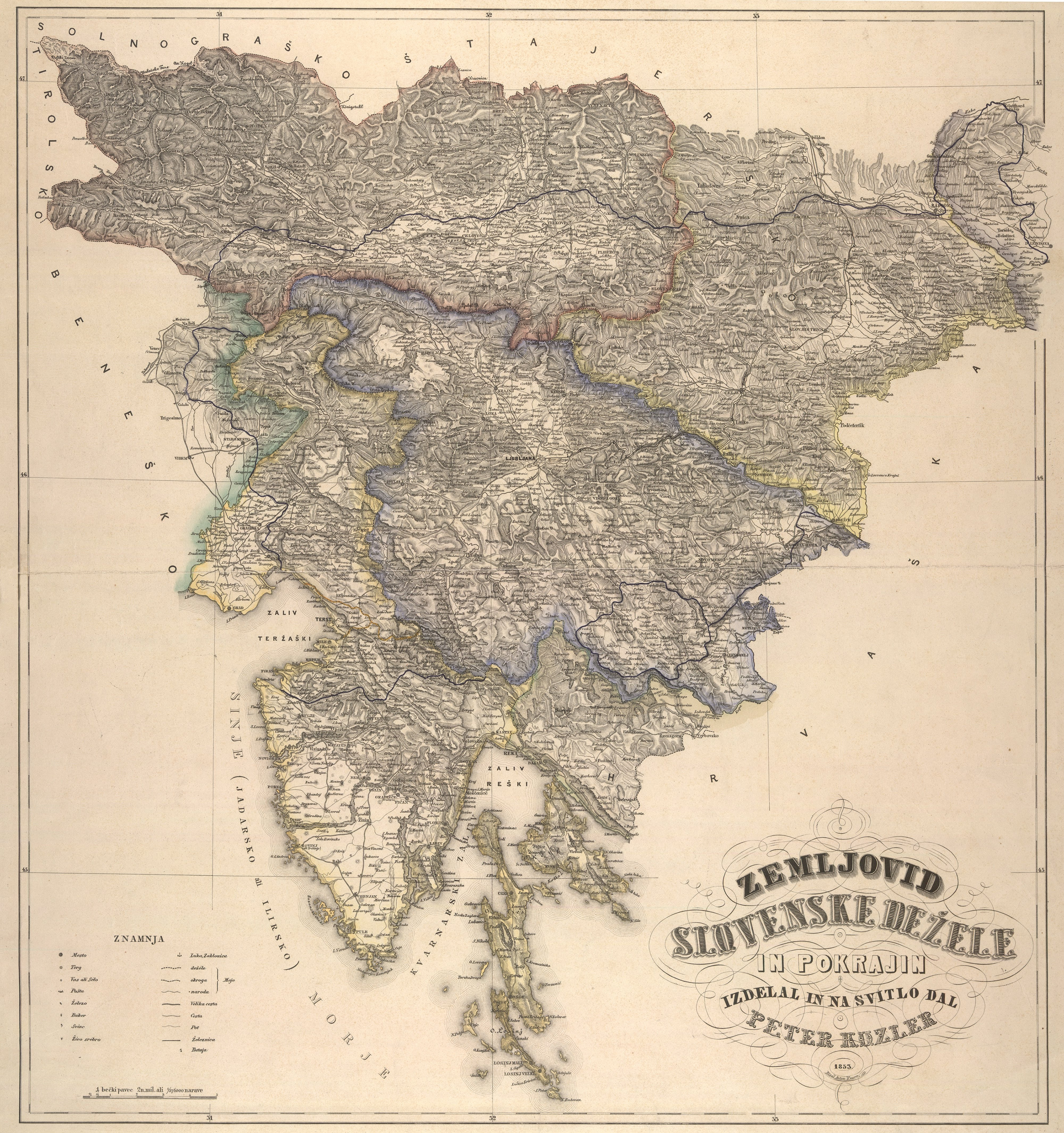
Slovenščina: Zemljevid Slovenske dežele in pokrajin, autor sl:Peter Kozler
English: A map of the Slovene Land and Provinces, author en:Peter Kozler
Hrvatski: Zemljovid slovenskih zemalja i pokrajina, autor hr:Peter Kozler |
|||||||||
| Date | (made), 1853 (published) | |||||||||
| Source | map-of-slovenian-lands-and-regions-peter-kozler/1wF72-V4fXp0jg — Google Arts & Culture | |||||||||
| Creator |
Peter Kozler |
|||||||||
| Geotemporal data | ||||||||||
| Bounding box |
|
|||||||||
| Georeferencing | ||||||||||
Licensing edit
.jpg&action=edit§ion=2)
|
This work is in the public domain in its country of origin and other countries and areas where the copyright term is the author's life plus 100 years or fewer. | |
| This file has been identified as being free of known restrictions under copyright law, including all related and neighboring rights. | |
File history
Click on a date/time to view the file as it appeared at that time.
| Date/Time | Thumbnail | Dimensions | User | Comment | |
|---|---|---|---|---|---|
| current | 08:54, 6 November 2019 | | 4,000 × 4,258 (8.48 MB) | Sporti (talk | contribs) | == {{int:filedesc}} == {{Information |Description= {{sl|Zemljevid Slovenske dežele in pokrajin, autor sl:Peter Kozler}} {{en|A map of the Slovene Land and Provinces, author en:Peter Kozler}} {{hr|Zemljovid slovenskih zemalja i pokrajina, autor hr:Peter Kozler}} |Source=https://artsandculture.google.com/asset/map-of-slovenian-lands-and-regions-peter-kozler/1wF72-V4fXp0jg |Date=1848 (made), 1853 (published) |Author=Peter Kozler }} == {{int:license-header}} == {{PD-old-100}} [[C... |
You cannot overwrite this file.
File usage on Commons
The following 2 pages use this file:
.jpg&oldid=668295458)