File:Ziegenhain.png
Size of this preview: 463 × 599 pixels. Other resolutions: 185 × 240 pixels | 371 × 480 pixels | 593 × 768 pixels | 791 × 1,024 pixels | 1,825 × 2,362 pixels.
Original file (1,825 × 2,362 pixels, file size: 557 KB, MIME type: image/png)
Captions
Captions
Add a one-line explanation of what this file represents
Summary edit
| Description |
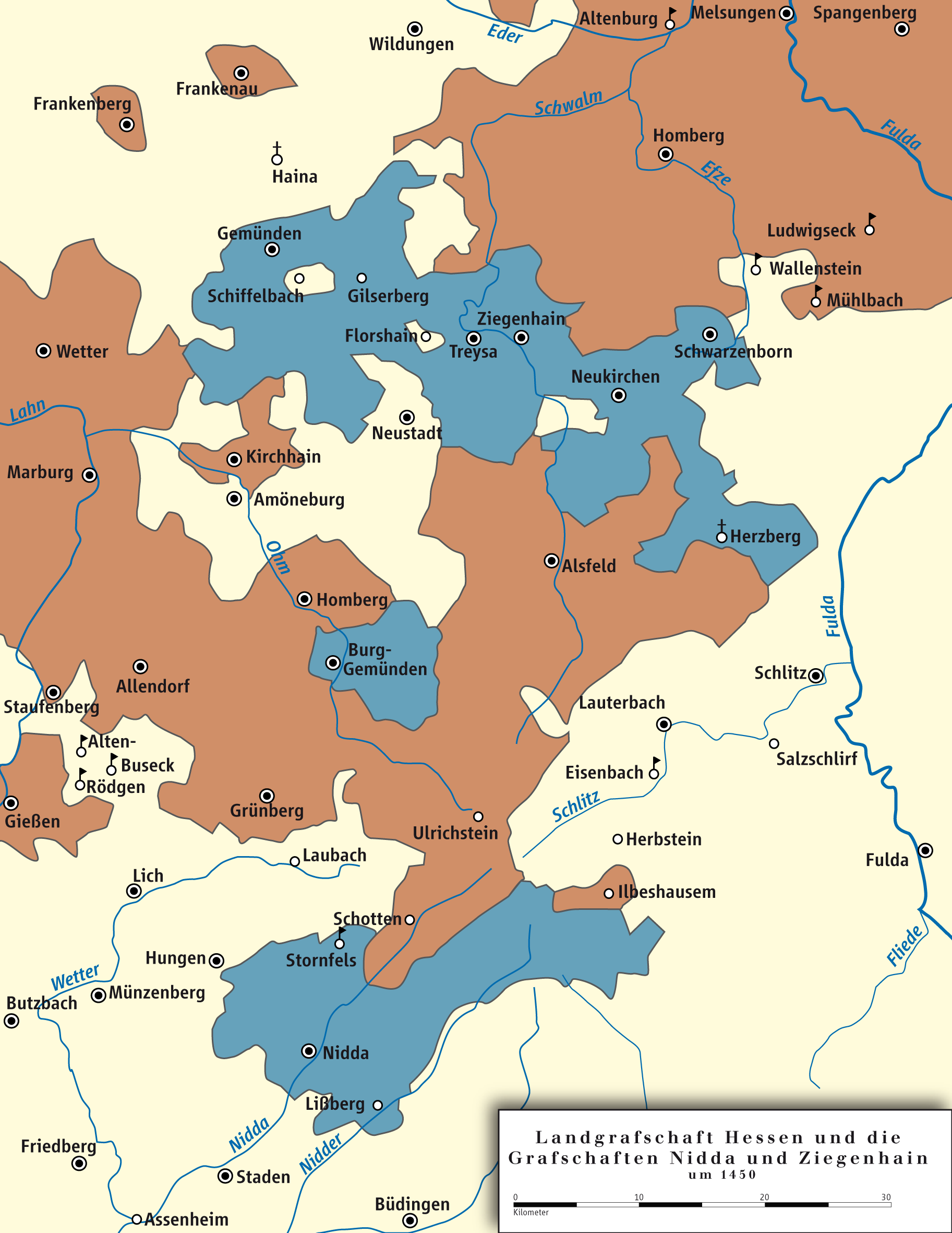
English: Landgraviat of Hesse and the Counties of Ziegenhain and Nidda, 1450
Deutsch: Landgrafschaft Hessen und die Grafschaften Ziegenhain und Nidda, 1450 |
||||||||
| Date | |||||||||
| Source | own drawing/Source of Information: Putzger – Historischer Weltatlas, 89. Auflage, 1965; Westermanns Großer Atlas zur Weltgeschichte, 1969; Haacks geographischer Atlas. VEB Hermann Haack Geographisch-Kartographische Anstalt, Gotha/Leipzig, 1. Auflage, 1979. | ||||||||
| Author | Ziegelbrenner | ||||||||
| Permission (Reusing this file) |
I, the copyright holder of this work, hereby publish it under the following licenses:
This file is licensed under the Creative Commons Attribution 2.5 Generic license.
You may select the license of your choice. |


|
This map has been made or improved in the German Kartenwerkstatt (Map Lab). You can propose maps to improve as well.
|

|
This historical map image could be re-created using vector graphics as an SVG file. This has several advantages; see Commons:Media for cleanup for more information. If an SVG form of this image is available, please upload it and afterwards replace this template with
{{vector version available|new image name}}.
It is recommended to name the SVG file “Ziegenhain.svg”—then the template Vector version available (or Vva) does not need the new image name parameter. |
File history
Click on a date/time to view the file as it appeared at that time.
| Date/Time | Thumbnail | Dimensions | User | Comment | |
|---|---|---|---|---|---|
| current | 17:05, 23 January 2012 | | 1,825 × 2,362 (557 KB) | Ziegelbrenner (talk | contribs) | 2012-01-23 |
| 13:35, 20 January 2012 |  | 1,825 × 2,362 (1.04 MB) | Ziegelbrenner (talk | contribs) | {{Information |Description ={{en|1=Landgraviat of Hesse and the Counties of Ziegenhain and Nidda, 1450}} {{de|1=Landgrafschaft Hessen und die Grafschaften Ziegenhain und Nidda, 1450}} |Source ={{own}}dsbds |Author =[[User:Ziegelbrenner| |
You cannot overwrite this file.
File usage on Commons
There are no pages that use this file.
File usage on other wikis
The following other wikis use this file:
- Usage on af.wikipedia.org
- Usage on bg.wikipedia.org
- Usage on de.wikipedia.org
- Usage on en.wikipedia.org
- Usage on fr.wikipedia.org
- Usage on it.wikipedia.org
- Usage on nl.wikipedia.org
- Usage on ru.wikipedia.org