File:Zonobiome.png

Size of this preview: 800 × 434 pixels. Other resolutions: 320 × 174 pixels | 640 × 347 pixels | 1,024 × 556 pixels | 1,280 × 695 pixels | 2,560 × 1,390 pixels | 4,779 × 2,594 pixels.
Original file (4,779 × 2,594 pixels, file size: 4.47 MB, MIME type: image/png)
Captions
Captions
Add a one-line explanation of what this file represents
Summary edit
| Description |
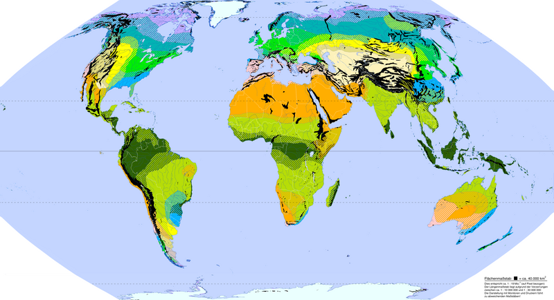
Deutsch: Zonobiome und Zonoökotone der Erde nach Walter und Breckle |
| Date | 12.06.2012 |
| Source | Own work |
| Author | Ökologix |
Quellen edit
Kartographie: Eckert VI-Projektion (nahezu flächentreu, realistische Größenverhältnisse, relativ wenig verzerrt), erstellt mit geo.dianacht.de archive copy at the Wayback Machine (Lizenz CC-BY)
Datengrundlagen:
- Heinrich Walter: "Vegetation und Klimazonen: Grundriß der globalen Ökologie", Ulmer, Stuttgart - 1990. ISBN 3-8001-2619-2
- Georg Grabherr: "Farbatlas Ökosysteme der Erde", Ulmer, Stuttgart - 1997, ISBN 3-8001-3489-6
Legende edit
I – Zonobiom der tropischen Regenwaldgebiete
II – Zonobiom der tropisch-subtropischen Regenzeitenwälder und Savannen
III – Zonobiom der heißen Halbwüsten und Wüsten
IV – Mediterranes Zonobiom (Warmtemperate, dürre- und episodisch frostbelastete Gebiete mit Hartlaubwäldern)
V – Lorbeerwald-Zonobiom (Warmtemperate, regenreiche, episodisch frostbelastete Gebiete mit immergrünen Wäldern)
VI – Nemorales Zonobiom (Winterkalte Gebiete mit sommergrünen Wäldern)
VII a) – Winterkaltes Vollwüsten-Zonobiom
VII b) – Winterkaltes Halbwüsten-Zonobiom
VII c) – Winterkaltes Steppen-Zonobiom
VIII – Boreales Zonobiom (Winterkalte Nadelwaldgebiete)
IX – Polares Zonobiom (Tundren und polare Wüsten)
Gebirgszüge = schwarz
Licensing edit
I, the copyright holder of this work, hereby publish it under the following license:
This file is licensed under the Creative Commons Attribution 3.0 Unported license.
- You are free:
- to share – to copy, distribute and transmit the work
- to remix – to adapt the work
- Under the following conditions:
- attribution – You must give appropriate credit, provide a link to the license, and indicate if changes were made. You may do so in any reasonable manner, but not in any way that suggests the licensor endorses you or your use.
File history
Click on a date/time to view the file as it appeared at that time.
| Date/Time | Thumbnail | Dimensions | User | Comment | |
|---|---|---|---|---|---|
| current | 19:04, 12 July 2012 | | 4,779 × 2,594 (4.47 MB) | Fährtenleser (talk | contribs) | Maßstabsangaben hinzugefügt, kleiner Korrekturen bei Flüssen und Gebirgen |
| 04:48, 19 June 2012 |  | 4,779 × 2,594 (4.39 MB) | Fährtenleser (talk | contribs) | Antarktis hinzugefügt (sowie kleinere "kosmetische" Korrekturen)<p> Kartendaten: * [http://geology.com/world/antarctica-map.jpg Geographische Antarktis-Karte auf geology.com] * [http://haysvillelibrary.files.wordpress.com/2009/12/antarctic-bedrock-top... | |
| 08:13, 13 June 2012 |  | 5,212 × 2,396 (4.04 MB) | Fährtenleser (talk | contribs) | Erneute Formatierung, da Webfarben noch nicht exakt mit den Hexcodes der Legend übereinstimmten | |
| 05:20, 13 June 2012 |  | 5,200 × 2,391 (3.98 MB) | Fährtenleser (talk | contribs) | Datei verkleinert | |
| 05:14, 13 June 2012 |  | 5,629 × 2,588 (2.01 MB) | Fährtenleser (talk | contribs) | Datei komprimiert | |
| 14:00, 12 June 2012 |  | 5,629 × 2,588 (2.19 MB) | Fährtenleser (talk | contribs) | {{Information |Description ={{de|1=Zonobiome und Zonoökotone der Erde nach Walter und Breckle}} |Source ={{own}} |Author =Ökologix |Date =12.06.2012 |Permission = |other_versions = }} Kartographie: ... |
You cannot overwrite this file.
File usage on Commons
There are no pages that use this file.
File usage on other wikis
The following other wikis use this file:
- Usage on bh.wikipedia.org
- Usage on de.wikipedia.org
- Usage on sl.wikipedia.org