File:Zurich area topographic map-fr.jpg

Size of this preview: 710 × 600 pixels. Other resolutions: 284 × 240 pixels | 568 × 480 pixels | 909 × 768 pixels | 1,212 × 1,024 pixels | 1,610 × 1,360 pixels.
Original file (1,610 × 1,360 pixels, file size: 932 KB, MIME type: image/jpeg)
File information
Structured data
Captions
Captions
Add a one-line explanation of what this file represents
Summary edit
| Camera location | 47° 22′ 40″ N, 8° 32′ 28″ E | View this and other nearby images on: OpenStreetMap |
|---|
| DescriptionZurich area topographic map-fr.jpg |
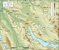
English: Topographic map in French of the area of Zürich, Switzerland
Note : for translation purpose, use the SVG version. |
||
| Date | |||
| Source |
English: Own work (see complete description on Image:Zurich_area_topographic_map-fr.svg) Approximate scale of the topographic data : 1:372,000 (accuracy : about 93 m). Note : The limit of the urbanized areas is approximate, particularly when several cities are close one of the other. Français : Création personnelle (voir description complète sur Image:Zurich_area_topographic_map-fr.svg) Échelle approximative des données topographiques : 1:372 000 (précision : environ 93 m). Note : La limite des zones urbaines est approximative, en particulier aux endroits où plusieurs agglomérations se touchent. Approximate geographic limits of the map (3" close) : * SW corner : 47° 10' 40" N – 08° 12' 40" E * SE corner : 47° 10' 40" N – 08° 53' 00" E * NE corner : 47° 33' 55" N – 08° 53' 08" E * NW corner : 47° 33' 55" N – 08° 12' 32" E |
||
| Author | Eric Gaba (Sting - fr:Sting) | ||
| Permission (Reusing this file) |
|
||
| Other versions |
[edit]
|
Licensing edit
I, the copyright holder of this work, hereby publish it under the following licenses:

|
Permission is granted to copy, distribute and/or modify this document under the terms of the GNU Free Documentation License, Version 1.2 or any later version published by the Free Software Foundation; with no Invariant Sections, no Front-Cover Texts, and no Back-Cover Texts. A copy of the license is included in the section entitled GNU Free Documentation License.http://www.gnu.org/copyleft/fdl.htmlGFDLGNU Free Documentation Licensetruetrue |
This file is licensed under the Creative Commons Attribution-Share Alike Attribution-Share Alike 4.0 International, 3.0 Unported, 2.5 Generic, 2.0 Generic and 1.0 Generic license.
- You are free:
- to share – to copy, distribute and transmit the work
- to remix – to adapt the work
- Under the following conditions:
- attribution – You must give appropriate credit, provide a link to the license, and indicate if changes were made. You may do so in any reasonable manner, but not in any way that suggests the licensor endorses you or your use.
- share alike – If you remix, transform, or build upon the material, you must distribute your contributions under the same or compatible license as the original.
You may select the license of your choice.
File history
Click on a date/time to view the file as it appeared at that time.
| Date/Time | Thumbnail | Dimensions | User | Comment | |
|---|---|---|---|---|---|
| current | 21:28, 17 July 2010 |  | 1,610 × 1,360 (932 KB) | Sting (talk | contribs) | Color profile |
| 16:29, 4 September 2008 |  | 1,610 × 1,360 (865 KB) | Sting (talk | contribs) | New standard colors | |
| 05:03, 19 March 2008 |  | 1,610 × 1,360 (967 KB) | Sting (talk | contribs) | {{Location|47|22|40|N|08|32|28|E|scale:200000}} <br/> {{Information |Description={{en|Topographic map in French of the area of Zürich, Switzerland<br/>''Note :'' for translation purpose, use the [[:Image:Zurich_area_to |
You cannot overwrite this file.
File usage on Commons
The following 5 pages use this file:
File usage on other wikis
The following other wikis use this file:
Metadata
This file contains additional information such as Exif metadata which may have been added by the digital camera, scanner, or software program used to create or digitize it. If the file has been modified from its original state, some details such as the timestamp may not fully reflect those of the original file. The timestamp is only as accurate as the clock in the camera, and it may be completely wrong.
| Orientation | Normal |
|---|---|
| Horizontal resolution | 89 dpi |
| Vertical resolution | 89 dpi |
| Software used | Adobe Photoshop 7.0 |
| File change date and time | 18:27, 17 July 2010 |
| Color space | Uncalibrated |


