File talk:Languages-Europe.svg
 | This file was nominated for deletion on 25 September 2009 but was kept. If you are thinking about re-nominating it for deletion, please read that discussion first. |
Problems edit
no, SV, da = is the Scandinavian, by greater difference in the stats than between the states
nld and deu is the same language, by greater difference in the stats than between the states.
Por and spa is the same language, by greater difference in the stats than between the states.
pol and cs is the same language, by greater difference in the stats than between the states.
--haabet 23:05, 11 March 2007 (UTC)
Note also that :
- As in the PNG file, Corsica island should be a blend of Italian and French. Else, it should be French.
- As in the PNG file, Alsace (north-eastern region of France) should be a blend of German and French.
- It would be a good thing if the borders were represented, as in the original JPEG image.
- — Xavier, 16:25, 25 June 2007 (UTC)
While there are probably not many people inhabiting the steppes between the lower Volga and Ural, their linguistic situation should be included in the map for the sheer size of that area. I would assume that there are more native speakers of Kazakh among them than of Russian; the article on Atyrau claims “almost 80% ethnic Kazakh” for the city in 1999. Dustsucker 19:48, 28 June 2007 (UTC)
Donst work edit
Hello. The image dosnt work. Greetings --Tlustulimu (talk) 18:05, 14 December 2008 (UTC)
German language in Poland edit
The map heavily exaggerates the spread of the German language in Poland. See these 2 maps for comparison: German language in 1910, and in 1950 (the latter roughly corresponds to the current situation). Delta 51 (talk) 01:11, 7 December 2014 (UTC)
Update edit
I updated the map to work better with en:Languages of Europe.
- changed the language codes to show the two-letter ISO 639-1 where available
- indicated the presence of dialects/varieties with three-letter ISO 639-3 codes (e.g. "(arp)" within the areal of "fr")
The map is alright, but some changes should still be made:
- labels
(scn) in Sicilyru in Kaliningradde in Hungaryen in Irelandtypo: "(ar)" for "(an)" (Aragonese)
- map
fix boundary between sv and noindicate kk areal in West Kazakhstanshow Malta andChannel Islandsremove excessive (pre-WW2) presence of German in Poland and Bohemia, per #German_language_in_Poland- Celtic areals are exaggerated or historical, see for: Irish, Scottish Gaelic, Welsh
the northernmost tip of Azerbaijan could be included as "European"
--Dbachmann (talk) 08:26, 8 September 2017 (UTC)
Fixed most of the problems I found with the map -- of course its accuracy can be improved further, but I think it is mostly correct/complete now. --Dbachmann (talk) 15:31, 11 September 2017 (UTC)
Collection of source maps edit
The map con only ever aspire to low resolution, but in contrast to File:Languages1.svg and related files (which have been criticised for implying greater accuracy than they can deliver) it has the possibility to use hatching to indicate the presence of a multilingual situation in a general area. This is probably the right way to go for this type of map. The sources for this map are other maps which show smaller regions in greater detail. Of course these maps in turn have to be based on identifiable sources. De facto, we just have to work with what we have, and then try to improve that step by step. --Dbachmann (talk) 06:18, 12 September 2017 (UTC)
Eastern Europe edit
For an overview see File:Map of the ethnic groups living in the Soviet Union.jpg (1979 Soviet census)
- Russian/Ukrainian
-
 Belarus (2009)
 -
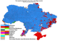 Ukraine (2001)
 -
 Estonia (2011/14)
 -
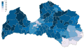 Latvia (2011)
 -
 Latvia (2011): Russian majorities in red, significant Belorusian minorities in orange
 -
 Ukrainians in Russia (2010)
 -
 Russians in Belarus (2009)
 -
 Ukrainians in Belarus (2009)


.svg)


- Caucasus
-
 Ethnic groups of the Caucasus (CIA publication, 1995)

- Uralic/Turkic
-
 Uralic (unreferenced overview, consult census data directly)
 -
 Altaic, Turkic and Uralic (unreferenced overview, consult census data directly)
.png)
.png)
Balkans edit
-
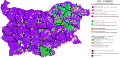 Bulgaria (2011)
 -
 Macedonia (2002)
 -
 Moldova (2004)
 -
 Bulgarian in European Turkey (2006/15)
 -
 Montenegro (2011)
 -
 Slovenian (1990 source, update/verification needed)
 -
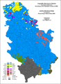 Serbia (2002)
 -
 Kosovo (2011)
 -
![Romanians (ethnographic map, disparate sources [1910-2002] listed in image page, use with care)](https://upload.wikimedia.org/wikipedia/commons/thumb/4/45/RomaniansInBalkans.png/105px-RomaniansInBalkans.png) Romanians (ethnographic map, disparate sources [1910-2002] listed in image page, use with care)
Romanians (ethnographic map, disparate sources [1910-2002] listed in image page, use with care)


![Romanians (ethnographic map, disparate sources [1910-2002] listed in image page, use with care)](/wiki/File:RomaniansInBalkans.png)
Central Europe edit
-
 Poland (map shows areas with >10% non-Polish minorities as of 2011)
 -
 Poles in Lithuania (2001)
 -
 Poles in Belarus (2009)
 -
 Hungary (2011 census)
 -
 Slovakia (2011 census)


Western Europe edit
-
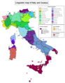 Italy ("source: RAI", verification needed)
 -
 Upper German (c. 1950)
 -
 Spain (1994)
 -
 German (general overview, unreferenced)
 -
 Scots (2011)


- Celtic languages
-
 Irish
Irish -
 Scottish Gaelic
 -
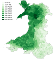 Welsh
Welsh -
 Breton (2004)


