File talk:October 2023 Gaza−Israel conflict.svg
Revert edit
@Red-tailed hawk: I don't think you meant to revert my change here. This file is frequently updated in accordance with the changes on the ground. The constant versions are c:File:October 2023 Gaza−Israel conflict (7– 8 October).svg and c:File:October 2023 Gaza−Israel conflict (9 October).svg Ecrusized (talk) 21:24, 10 October 2023 (UTC)
.svg)
.svg)
Translation edit
@Veggies: The file appears to be void of text and it's not possible to translate using svg translate tool. Is there a way to fix this? https://svgtranslate.toolforge.org Ecrusized (talk) 08:06, 11 October 2023 (UTC)
Date? edit
It would be reasonable if the black box at the top left would include the date. Like "The situation as of [time].", or "Map last updated: [time]." There are multiple maps at the article, but confusingly not even the file page states what time it depicts. GMRE (talk) 15:10, 11 October 2023 (UTC)
- @GMRE: It represent the current date unless otherwise stated. Ecrusized (talk) 16:40, 11 October 2023 (UTC)
- I agree it should show the date. Readers shouldn't have to guess whether or not it's being updated daily. GeoEvan (talk) 05:07, 13 October 2023 (UTC)
Yellow area edit
what does the yellow area represent? Abo Yemen (talk) 10:11, 14 October 2023 (UTC)
- I don't really get what "evacuated area" means Abo Yemen (talk) 10:11, 14 October 2023 (UTC)
- @Abo Yemen: It represents the area in Israel where all civilians have been evacuated, so nobody lives there at the moment because of the fighting. Hope this helps 🙂 Johnson524 (talk) 11:15, 14 October 2023 (UTC)
- so these areas are controlled by Hamas? Abo Yemen (talk) 11:16, 14 October 2023 (UTC)
- @Abo Yemen: No, they are controlled by Israel: but the threat of Hamas returning is high so civilians have been evacuated. Johnson524 (talk) 11:19, 14 October 2023 (UTC)
- Oh okay thanks for the explanation 👍 Abo Yemen (talk) 11:22, 14 October 2023 (UTC)
- @Abo Yemen: No problem! If you need anything else feel free to ask 🙂 Johnson524 (talk) 11:29, 14 October 2023 (UTC)
- Oh okay thanks for the explanation 👍 Abo Yemen (talk) 11:22, 14 October 2023 (UTC)
- @Abo Yemen: No, they are controlled by Israel: but the threat of Hamas returning is high so civilians have been evacuated. Johnson524 (talk) 11:19, 14 October 2023 (UTC)
- so these areas are controlled by Hamas? Abo Yemen (talk) 11:16, 14 October 2023 (UTC)
- @Abo Yemen: It represents the area in Israel where all civilians have been evacuated, so nobody lives there at the moment because of the fighting. Hope this helps 🙂 Johnson524 (talk) 11:15, 14 October 2023 (UTC)
FR translation edit
There's a mistake in the translation, "Bière Sheva" should be "Beer-sheva". I tried fixing it myself, but the translation tool refused, arguing that the language already existed. Any idea how I can update an existing translation? Zmeeedik (talk) 13:26, 15 October 2023 (UTC)
- @Zmeeedik: Thank you for letting me know about this! Since you mentioned it, I went back and double-checked the names of a few kibbutz's on French Wikipedia, and found a few more typos. Cheers! Johnson524 (talk) 16:37, 15 October 2023 (UTC)
Battle of Zikim ongoing edit
Wikipedia article Battle of Zikim is still ongoing, based on sources cited in the article. Zikim is in Hamas control right now. WeatherWriter (talk) 02:39, 16 October 2023 (UTC)
- Wikipedia is not a source. That article needs to be updated. Ecrusized (talk) 08:11, 16 October 2023 (UTC)
- You do realize I said “sources in the Wikipedia article” right? So what, we just consider the sources in the article to be not sources? Fine, I’ll list them here: Al Jazeera — “Israel’s military said at 10am (07:00 GMT) that Palestinian fighters penetrated at least three military installations around the frontier – the Beit Hanoon border crossing (called Erez by Israel), the Zikim base, and the Gaza division headquarters at Reim. Hamas videos showed fighters running towards a burning building near a high concrete wall with a watchtower and fighters apparently overrunning part of an Israeli military facility and shooting from behind a wall…Several captured Israeli military vehicles were later pictured being driven into Gaza and paraded there.” & [1] & “This is How Al-Qassam’s Navel Units Stormed Zakim’s Fortified Military Base”. There is 3 sources right there saying the military base of Zakim is under Hamas control. You need a source saying Zakim is not under Hamas control to not continue violating Wikipedia’s original research policy. Map still needs updated. WeatherWriter (talk) 14:30, 16 October 2023 (UTC)
- Israel announced the control of all settlements which had militants' presence on the 9th.[2] Infiltrations and shootouts were nevertheless reported until the 14th, which the map showed. There has been no reports of clashes as of yet. Ecrusized (talk) 14:58, 16 October 2023 (UTC)
- Good to note, the Commons does not require a source to say a battle ended for a battle to be over, aka not to adhere to Wikipedia's no OR guidelines. That makes sense though given the Commons is separate from Wikipedia. Nonetheless, the map should be removed from the Wikipedia article due to the unverified info. WeatherWriter (talk) 21:35, 16 October 2023 (UTC)
- Israel announced the control of all settlements which had militants' presence on the 9th.[2] Infiltrations and shootouts were nevertheless reported until the 14th, which the map showed. There has been no reports of clashes as of yet. Ecrusized (talk) 14:58, 16 October 2023 (UTC)
- You do realize I said “sources in the Wikipedia article” right? So what, we just consider the sources in the article to be not sources? Fine, I’ll list them here: Al Jazeera — “Israel’s military said at 10am (07:00 GMT) that Palestinian fighters penetrated at least three military installations around the frontier – the Beit Hanoon border crossing (called Erez by Israel), the Zikim base, and the Gaza division headquarters at Reim. Hamas videos showed fighters running towards a burning building near a high concrete wall with a watchtower and fighters apparently overrunning part of an Israeli military facility and shooting from behind a wall…Several captured Israeli military vehicles were later pictured being driven into Gaza and paraded there.” & [1] & “This is How Al-Qassam’s Navel Units Stormed Zakim’s Fortified Military Base”. There is 3 sources right there saying the military base of Zakim is under Hamas control. You need a source saying Zakim is not under Hamas control to not continue violating Wikipedia’s original research policy. Map still needs updated. WeatherWriter (talk) 14:30, 16 October 2023 (UTC)
Yakhini edit
Could anybody add a caption for Yakhini (south of Gevim)? Thanks in advance. Vcohen (talk) 19:17, 23 October 2023 (UTC)
- @Vcohen: I'm working with the more knowledgeable editor/uploader of this file to add the caption for that moshav to the map. I tried to do it myself, but I think I did something wrong, so I'll wait for his word. It shouldn't take too long. Thanks. -- Veggies (talk) 06:50, 24 October 2023 (UTC)
mo translation edit
@Johnson524: You added a translation with the text Map kē że 2023 israel–hamas łar. You marked it as Moldovan, which it is certainly not (these are Latin characters for words that don't exist in that language). Despite my research, I cannot figure out what language it is supposed to be. Please feel free to restore if you can you provide. Magog the Ogre (talk) (contribs) 22:10, 29 October 2023 (UTC)
- @Magog the Ogre: Thanks for catching that! That's what I get for trusting a shady website that promised English to Moldovan translation. Oof. Johnson524 (talk) 00:21, 30 October 2023 (UTC)
Beach incursion edit
The beach incursion was not that large. Only confirmed territory taken was Bianco Resort on the coast. At most, you could expand the territory taken to the street leading up on the coast leading to the resort, no further confirmations Personisinsterest (talk) 00:44, 30 October 2023 (UTC)
Blocking of Salah al-Din Road not visible on the map? edit
According to the Wikipedia entry on the ongoing ground offensive, the Israeli forces have blocked Salah al-Din Road (though, unclear where on the road, but possibly south of Gaza City by my guess), but the map does not seem to show that. There are no blue area anywhere on the road south of Gaza City as shown on the map. Was this an omission by error, or was the blocking temporary? However, I have not seen anything in the article indicating that they had since then withdrawn from the road. Can someone kindly confirm this, please? Thanks! Chief of Staff (talk) 18:24, 31 October 2023 (UTC)
The line of "maximum extent of Palestinian advance" is very imprecise edit
There were no terrorists in the area of Netivot, Kfar Maimon and Shokeda. The places where there were battles to the east of highway 232 are Re'im, Mefalsim, Sa'ad, Ein HaBsor, Pri Gan, Mivthahim, Ofakim, and Yesha. In addition, the terrorists who massacred the nature party in Re'im advanced a little to the east of the road. The eastern line should be on road 232 with exceptions only in the places I mentioned above. The northern line should pass south of Karmia and Yad Mordehai. This map shows where there were casualties in the attack. It is almost completely identical to the infiltration map of the Hamas terrorists and it can be a basis for correcting the map. החבלן (talk) 09:49, 1 November 2023 (UTC)
- I'm not sure what your sources are. The Times of Israel very clearly states that Hamas fighters attacked Netivot [3]. Haaretz reports that Hamas fighters reached the outskirts of Kfar Maimon [4]. You may be right about Shokeda, however. I'll look at your map. -- Veggies (talk) 20:25, 2 November 2023 (UTC)
- @החבלן: According to The Times of Israel, Netivot was among the towns attacked by Hamas, I have also seen it included in a map by Statfor. Do you have any sources on what towns were attacked? Ecrusized (talk) 20:26, 2 November 2023 (UTC)
- There was a lot of disinformation and confusion in the early days. The fact that a place is mentioned in the report can be a mistake.
- The Hebrew Wikipedia has a template with a summary of all the places where a battle/ massacre took place.
- In Netivot there were several casualties from rockets on the first day and this may be the cause of the confusion.
- This is an interactive map prepared by the most popular TV channel in Israel: [5].
- I do not have access to the Haaretz newspaper website because it is closed with a paywall. Can you quote what it says there? Kfar Maimon is relatively close to road 231 which is the main road through which the terrorists passed. החבלן (talk) 22:23, 2 November 2023 (UTC)
- I have seen an interactive map called "oct7map.com" which shows where atrocities took place. However, I am not sure on the reliability of this open source project. Especially since reliable sources like The Times of Israel and Haaretz report that other settlements were also attacked. Ecrusized (talk) 12:27, 3 November 2023 (UTC)
- I found articles about what happened in Netivot: a terrorist vehicle arrived on the road near Netivot and was destroyed outside the city [6], [7]. החבלן (talk) 12:51, 3 November 2023 (UTC)
- That would still mean that the militants managed to reach Netivot. They just didn't manage to murder anybody there. Ecrusized (talk) 20:36, 3 November 2023 (UTC)
- Ecrusized, Yes, but that means they drove on the road to the Netivot entrance. Only the road should be marked and not the whole area.
- This means that my map is accurate with one correction: the road between Saad and Netivot.
- The oct7map, isn't the only source. I have also attached the link to N12.
- In summary: the current line is slightly wrong towards the west in the area of Yesha and Mivtachim. Both of these places were attacked on October 7.
- The map is very wrong towards the east in the Netivot and Ofakim areas. The terrorists drove to these cities only on the road and did not get off the road to the south or north. There were dozens of terrorists in Ofakim and it would be correct to mark the whole city (except the eastern area). In Netivot, there was one vehicle that stopped at the entrance to the city, so it would not be correct to mark the entire city.
- In the north, the terrorists did not reach Or HaNer, YadMordehai and Karmia.
- The map I made is much more accurate. I just need to add the road between Saad and Netivot. החבלן (talk) 19:23, 4 November 2023 (UTC)
- @החבלן: Your map is a bit minimalistic. According to 7octmap, only atrocities took place on the roads. But it is entirely plausible that the militants traversed the countryside to reach Ofakim and elsewhere. Ecrusized (talk) 19:48, 4 November 2023 (UTC)
- It is known for certain that the terrorists traveled on road 241 on the way to Ofakim. There is no known appearance of terrorists anywhere south or north of the road. There are several villages near the road and none of them reported any fights or murders. Why should it be assumed that they arrived in other ways besides the road?
- For Netivot this is even more true. There is one vehicle that arrived via road 25. החבלן (talk) 20:03, 4 November 2023 (UTC)
- Agree with החבלן. The map is very inaccurate, which is probably due to the confusion in the first few days. I just want to add that the amount of nonsense and fake news in the world journalism about the war is very large, and it is recommended to look at more than one site (and preferably news sites from different countries) before determining facts. Good Day, Neriah (talk) 20:11, 5 November 2023 (UTC)
- There is another village that is missing from the current map. In the village of Yated, battles took place on 7/10 and 8/10. The villages near it were not attacked (except for Pri Gan which is included in the current line). החבלן (talk) 08:20, 6 November 2023 (UTC)
- Agree with החבלן. The map is very inaccurate, which is probably due to the confusion in the first few days. I just want to add that the amount of nonsense and fake news in the world journalism about the war is very large, and it is recommended to look at more than one site (and preferably news sites from different countries) before determining facts. Good Day, Neriah (talk) 20:11, 5 November 2023 (UTC)
- @החבלן: Your map is a bit minimalistic. According to 7octmap, only atrocities took place on the roads. But it is entirely plausible that the militants traversed the countryside to reach Ofakim and elsewhere. Ecrusized (talk) 19:48, 4 November 2023 (UTC)
- That would still mean that the militants managed to reach Netivot. They just didn't manage to murder anybody there. Ecrusized (talk) 20:36, 3 November 2023 (UTC)
- I uploaded a separate file with a corrected version of the map to clarify what the changes are:
- 1. The villages of Yated and Mivtahim were attacked on 7/10.
- 2. In the Ofakim area: in the villages of Urim, Patish, Maslul there was no presence of terrorists. There are several military bases near Urim and there were battles there.
- 3. In the Netivot area: there were no terrorists in Kfar Maimon, Shokeda and Zimrat [8]. There were terrorists at the entrance to Netivot and in Yakhini.
- 4. In the Sderot area: there were no terrorists in Or HaNer, Karmia and Yad Mordehai. The terrorists were arrested outside the fences of Yad Mordehai [9]
- Ecrusized, Veggies and Neriah| do you approve of these changes? החבלן (talk) 13:56, 6 November 2023 (UTC)
- Comment: Can this map be deleted or merged after the changes are approved or denied so there can continue to have one centrally used map? Cheers! Johnson524 (talk) 15:29, 6 November 2023 (UTC)
- Yes, of course. החבלן (talk) 16:24, 6 November 2023 (UTC)
 . Neriah (talk) 20:59, 7 November 2023 (UTC)
- I find it to be a bit original research to minimalize the Palestinian advance map simply because no killings have taken place in uninhabited areas. Ecrusized (talk) 18:46, 11 November 2023 (UTC)
- I linked above to the map of n12 - the largest TV channel in Israel, the map is not based on deaths but on events.
- The wsj map also supports this.
- The NYT map also supports this map.
- The current line is based on confusion from the first days of the war without any source.
- There is no source that they were armed in Urim, Patish, Maslul, Kfar Maimon, Shokeda, Zimrat, Or HaNer, Karmia and Yad Mordehai. החבלן (talk) 07:13, 12 November 2023 (UTC)
- I don't have access to the NYT map, but the N12 map, along with several of the aforementioned sources, seem to support the proposed update. It doesn't make sense to insist on using outdated sources and articles that were published before the public had the full picture of what happend. I support the suggestions made by החבלן. מיכאל.צבאן (talk) 07:41, 6 December 2023 (UTC)
- Yes, of course. החבלן (talk) 16:24, 6 November 2023 (UTC)
- Comment: Can this map be deleted or merged after the changes are approved or denied so there can continue to have one centrally used map? Cheers! Johnson524 (talk) 15:29, 6 November 2023 (UTC)
ISW and "claimed furthest Israeli advances" edit
Greetings Ecrusized and Veggies. First of all, allow me to express my compliments on the diligent work you both have been doing to maintain and update this file.
Now that it is apparent that the only source you are using for information regarding Israeli military presence in the Gaza Strip is the map of the Institute for the Study of War, I wanted to share my concerns regarding your lack of distinction between two separate geographic designations the ISW is calling "reported Israeli clearing operations" and "claimed furthest Israeli advances."
While ISW does not go into detail on why certain areas might be represented by one layer or the other, someone familiar with their previous work can infer from their language that the former designation likely refers to areas that the Institute can be fairly certain are under Israeli military control; the latter would seem to mean that the Institute is less confident about the status of these particular areas and may only be including these "claims" for the sake of being exhaustive.
Included in these "unclear" areas is much of Juhor ad-Dik, along with most, if not all, of Al-Zahraa and Al-Mughraqa, three not-insigificant settlements with a combined pre-war population of over 20,000. Notably, there appear to be no other reliable sources indicating Israeli occupation of these villages, or recent combat therein. Other places bearing the "claimed furthest Israeli advances" designation include a number of city blocks in the northwestern part of Gaza and a strip of land adjacent to the border fence apparently connecting the IDF's coastal front with its positions around Beit Hanoun.
On our map, which is undoubtedly viewed by at least tens of thousands of Wikipedia viewers on a daily basis, no distinction is drawn between the ISW's two geographic designations here; both are amalgamated into an area purportedly representing the "Gaza Strip under Israeli control," despite the fact that ISW makes no such definitive claim regarding much of this territory. Do you agree that this is something of a misrepresentation and something ought be done to address this? Once again, my compliments and appreciation go out to you for your continued improvements to this very important file.
SaintPaulOfTarsus (talk) 03:04, 10 November 2023 (UTC)
- @SaintPaulOfTarsus: Majority of the maps I have seen online include a larger area of control when it comes to Israel. ISW is generally conservative in this regard. Their classification for "claimed control" comes from less reliable confirmations. For example, while "assessed control" comes from direct geolocation of IDF troops, the "claimed control" areas comes from where the militants have been firing at IDF, according to the latest report. I would be interested in hearing more regarding this. You could open a discussion at the article talk page. If users prefer that only "assessed control" areas be shown, it can easily be edited. Ecrusized (talk) 09:49, 10 November 2023 (UTC)
Not coded properly edit
According to the advice of Commons:Translation possible/Learn more#Coding, there should be an english version, even when english is the default. Without this, there may be problems with browsers configured for multiple languages. (I am one of those who has such a browser and is facing problems.) This file does not follow that advice. Please correct that. Arnav Bhate (talk) 06:34, 13 November 2023 (UTC)
Ira (Indian removal act) edit
The Indian removal act was a group of native Americans who were forced to move to a tiny peice of land by Andrew Jackson and also had to walk on the trail of tears which ended lives for many because it was a long walk and there were not many resources to live. This information just gives u a idea of what the IRA is aka the Indian removal act. 67.80.167.17 23:26, 13 November 2023 (UTC)
)
Glitch edit
@Ecrusized: your last edit to the images have a text glitch, as if multiple words from different languages are on top of others. ObserveOwl (talk) 09:58, 28 November 2023 (UTC)
Time to update? edit
@Ecrusized Hello, if you don’t mind I would suggest some updates on the map. Obviously, a constant day to day update is a major task however in the Wikipedia map the frontlines have been alike the ones since the ceasefire began. I’d do it myself if I didn’t have absolutely zero experience with SVG’s and Inkscape
Territory withdrawn from:
There have been reports indicating israel is withdrawing most of its troops from northern Gaza for a new southern ground assault
https://www.aljazeera.net/news/2023/12/1/خبير-عسكري-إسرائيل-سحبت-آلياتها-من-غزة
These withdrawals include Al shifa hospital which was raided last month https://m.economictimes.com/news/defence/israeli-army-withdraws-from-gaza-hospital-after-truce-hamas-ministry/amp_articleshow/105480072.cms
https://www.instagram.com/reel/C0KH0b8Krdx/?igshid=MzRlODBiNWFlZA== This video on 28 November during the ceasefire shows an absence of Israeli forces however the damage is present, suggesting Israel has pulled out as far as Gaza port since November, however clashes around tel Al hawa and shujaiya mean that not all forces withdrew
Territory never confirmed to be under Israeli control
Currently, no evidence suggests israel has had a presence in Zahra and mughraqa, let alone captured them. As for beit Hanoun, the city never fell under full Israeli occupation (it is shown as a blue dot in the comprehensive map). There are still heavy clashes and urban warfare in beit Hanoun, far from being occupied and pacified by Israel
https://www.understandingwar.org/backgrounder/iran-update-december-5-2023
Renewed assaults Israeli advanced on roads in Jabalia, as well as new axis, the southern front as Israeli soldiers advance on khan yunis
For a simplified summary:
File:Gaza frontlines map suggestions.png
thanks ~Fahad The Great Mule of Eupatoria (talk) 06:59, 6 December 2023 (UTC)
- @The Great Mule of Eupatoria: I don't know how reliable it would be to cite AJ and Economic Times for the withdrawal of IDF. ISW still shows these areas as under Israeli control, citing two separate sources would possibly create SYNTH issues. Before switching to ISW, some editors were calling for the removal of the map for using synthesis so I have to stick with a single source. Ecrusized (talk) 09:53, 6 December 2023 (UTC)
- Understandable, it was just a suggestion considering the changed frontlines following the ceasefire. I wasn’t aware that the map primarily cited ISW The Great Mule of Eupatoria (talk) 10:00, 6 December 2023 (UTC)
- Why would the map be solely based on the ISW, when the ISW is an openly pro-US and highly biased think tank? For example, when I visit their homepage on January 2nd, I immediately get an article titled "The lands Ukraine must liberate". Even then, their current interactive map looks very different than the map here on wikipedia (https://storymaps.arcgis.com/stories/2e746151991643e39e64780f0674f7dd).
- I guess one thing that could help is relabeling the map to describe the Israeli areas not as "controlled", but rather labeling them as being areas where the Israeli military has operated, which is actually how ISW labels it (as "clearing operation areas"):
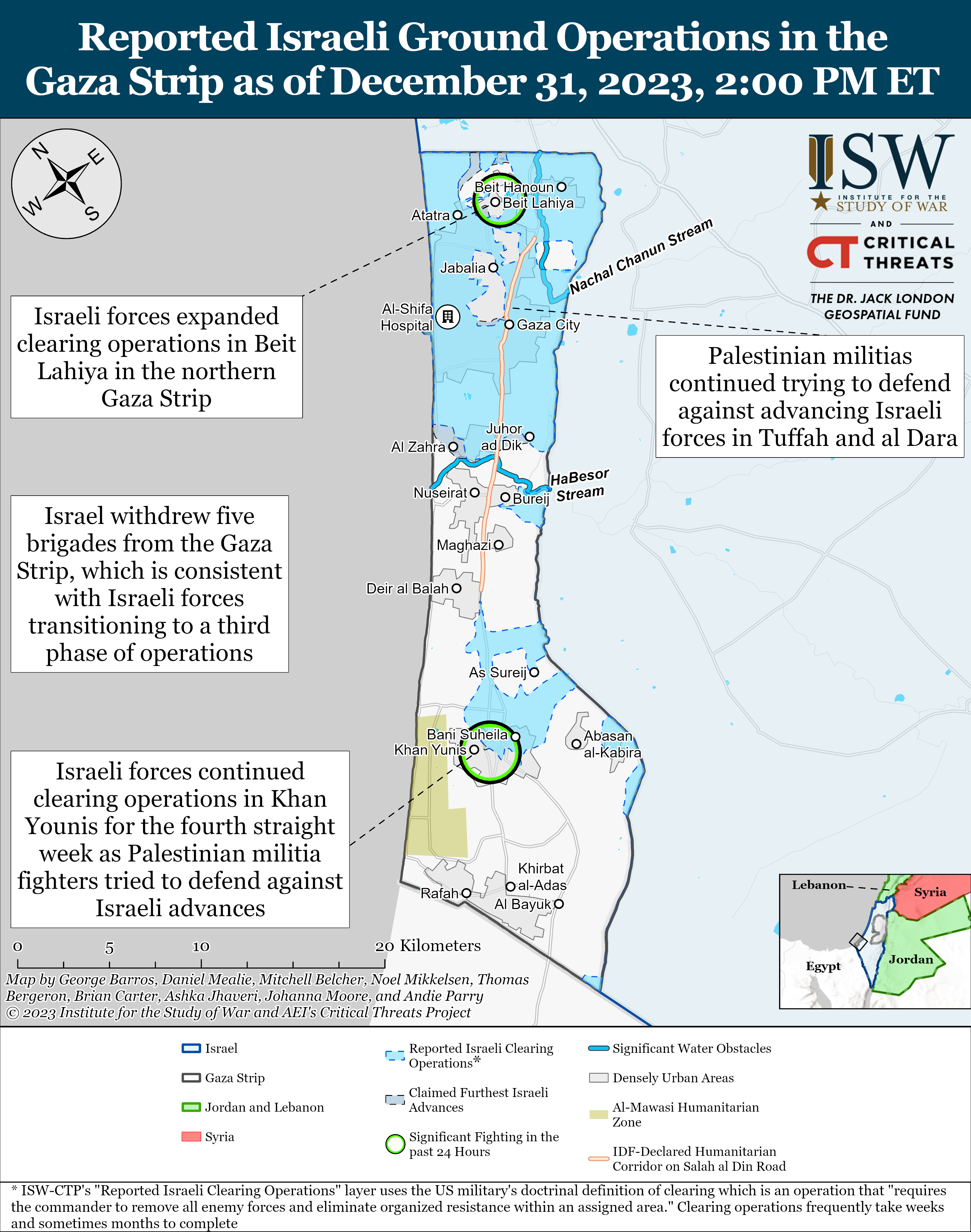
- https://www.understandingwar.org/sites/default/files/Gaza%20Clearing%20Map%20December%2031%2C2023.png
- As it stands the wikipedia map seems very inconsistent with other maps one can find. 73.129.27.100 15:16, 2 January 2024 (UTC)
- Understandable, it was just a suggestion considering the changed frontlines following the ceasefire. I wasn’t aware that the map primarily cited ISW The Great Mule of Eupatoria (talk) 10:00, 6 December 2023 (UTC)
Maps labels edit
The current map labels make no sense.
- Gaza Strip under Palestinian control
- Gaza Strip under Israeli control
What control do Palestinians have? Chaos is not control. People running around like chickens with their heads cut of is not order. It would make much more sense to change the labels to "Gaza Strip with IDF presence" and "Gaza Strip without IDF presence". Stefán Örvarr Sigmundsson (talk) 20:30, 27 December 2023 (UTC)
 Not done: While an argument could be made that Israel does not "control" the parts of the Gaza strip the IDF is currently present in, Hamas definitely doesn't, so this wording works at simplifying the map at a glance, as map labels are meant to be short. The labels could potentially be changed to add "reported" to the front of them, but this is already implied and would again unnecessarily increase the label lengths. Hope this was helpful, and if you have any further comments on this, I'm willing to discuss. Johnson524 (talk) 16:05, 4 January 2024 (UTC)
Update the map edit
Hello. ISW updated its report about the war yesterday and based on that report eastern part of bureij, and also larger parts of khuzaa are now under Israeli control. Please update the map. AmSiDeAth (talk) 17:49, 29 December 2023 (UTC)
 Done: Areas have been updated already by Ecrusized. Johnson524 (talk) 15:52, 4 January 2024 (UTC)
Blue Area edit
The map key MUST be edited, the blue area should denote "The extent of the Israeli invasion", or "Areas that were invaded by Israel at some point during the offensive", not falsely "Gaza strip under Israeli control". The blue areas of the Gaza strip are not under Israeli control for the most part. 196.249.200.106 08:59, 4 January 2024 (UTC)
- Not done I personally see no problem with the wording: it's neutral for both sides of the conflict (i.e. "extent of Palestinian advance" and not "areas invaded by Hamas" as well). Also, the blue areas are supported by the sources listed in the description box under the image, which are very unlikely to be "for the most part" incorrect, unless you have another reliable source stating otherwise. If the map is incorrect after an event that happened within the day, it will likely be updated by Ecrusized at the end of the day based on the aforementioned sources. Johnson524 (talk) 15:50, 4 January 2024 (UTC)
- Greetings @Johnson524, I'd like to point out that the sources for the "blue areas" use the term "reported Israeli clearing operations" and "claimed furthest Israeli advances," not "under Israeli control."
- What's more, they include this disclaimer:
- ISW-CTP's "Reported Israeli Clearing Operations" layer uses the US military's doctrinal definition of clearing which is an operation that "requires the commander to remove all enemy forces and eliminate organized resistance within an assigned area." Clearing operations frequently take weeks and sometimes months to complete.
- Note that the sources say nothing about "control." That appears to be an oversimplification created by the editors of the file. On the contrary, the sources suggest that there may actually still be "enemy forces" and "organized resistance" within the blue areas, which seems rather contradictory to the concept of "control" over these areas.
- To accurately reflect the sources, we must update the legend.
- SaintPaulOfTarsus (talk) 22:57, 4 January 2024 (UTC)
- Hello @SaintPaulOfTarsus, and thank you for taking the time to write this well-made response 🙂 I want to stress I am not opposed to changing the map captions per say, but I am opposed to calling either side 'invading' like the IP was suggesting. I believe that while there is an argument that Israel does not "control" the parts of the Gaza strip the IDF is currently present in, Hamas definitely doesn't, so this wording still works at simplifying the map at a glance as map labels are meant to be short. Do you disagree with this reasoning? This is how I view it at least, but I'd be open to hearing your response. Cheers! Johnson524 (talk) 08:43, 5 January 2024 (UTC)
- @Johnson524, the debate appears to boil down to simplicity vs. accuracy, and I'm not able to think of a more accurate replacement caption that keeps the labels quite as simple. Maybe this is better suited as a request for comment on the talk page of the 2023 Israel-Hamas war Wikipedia article? Thanks, SaintPaulOfTarsus (talk) 16:59, 5 January 2024 (UTC)
- @SaintPaulOfTarsus: Sounds good to me 🙂 I'm in the process of another (my first actually) RFC at the moment, so I wouldn't be too comfortable starting another one, but if that's something you're passionate about I think it's good idea. Cheers! Johnson524 (talk) 01:38, 6 January 2024 (UTC)
- @Johnson524, I'm quite the beginner editor myself, but I will look into starting an RfC on this topic in the coming days. It was a pleasure discussing this matter with you. My regards, SaintPaulOfTarsus (talk) 02:26, 6 January 2024 (UTC)
- @SaintPaulOfTarsus: Same here, I hope you decide to stick around on the project. Johnson524 (talk) 02:37, 6 January 2024 (UTC)
- @Johnson524, I'm quite the beginner editor myself, but I will look into starting an RfC on this topic in the coming days. It was a pleasure discussing this matter with you. My regards, SaintPaulOfTarsus (talk) 02:26, 6 January 2024 (UTC)
- @SaintPaulOfTarsus: Sounds good to me 🙂 I'm in the process of another (my first actually) RFC at the moment, so I wouldn't be too comfortable starting another one, but if that's something you're passionate about I think it's good idea. Cheers! Johnson524 (talk) 01:38, 6 January 2024 (UTC)
- @Johnson524, the debate appears to boil down to simplicity vs. accuracy, and I'm not able to think of a more accurate replacement caption that keeps the labels quite as simple. Maybe this is better suited as a request for comment on the talk page of the 2023 Israel-Hamas war Wikipedia article? Thanks, SaintPaulOfTarsus (talk) 16:59, 5 January 2024 (UTC)
- Hello @SaintPaulOfTarsus, and thank you for taking the time to write this well-made response 🙂 I want to stress I am not opposed to changing the map captions per say, but I am opposed to calling either side 'invading' like the IP was suggesting. I believe that while there is an argument that Israel does not "control" the parts of the Gaza strip the IDF is currently present in, Hamas definitely doesn't, so this wording still works at simplifying the map at a glance as map labels are meant to be short. Do you disagree with this reasoning? This is how I view it at least, but I'd be open to hearing your response. Cheers! Johnson524 (talk) 08:43, 5 January 2024 (UTC)
Beit Hanoun? edit
The Battle of Beit Hanoun page on wikipedia says that the IDF has retreated from Beit Hanoun. Does this mean the map should not have Beit Hanoun be in Blue?
specifically:
'On December 24, Israeli forces withdrew from Beit Hanoun amidst heavy fighting with Palestinian militant groups. Returning civilians to the ruins of the town reported that no vehicles were in sight. Israeli forces continue to shell the city. Per royanews and Aljazeera
Former residents of Beit Hanoun returned to the remains of the town after Israeli forces had withdrawn from it. The destruction had encompassed the entire city, and residents said that “all structures were destroyed”, and described most of Beit Hanoun as being “razed to the ground” per Al Jazeera Genabab (talk) 21:24, 11 January 2024 (UTC)
- @Genabab: Likely not, since Israel still has control over the town even if the IDF is not currently conducting operations there. Cheers! Johnson524 (talk) 07:26, 15 January 2024 (UTC)
- @Johnson524Apologies for the late reply.
- But if the IDF is saying that it withdrew, wouldn't that mean it isn't under their control.
- Apparently last month on the 15th Hamas even launched rocket attacks on Israel from Beit Hanoun (according to the Institute for the study of War https://www.understandingwar.org/backgrounder/iran-update-january-16-2024). I'm not certain that this still indicates Israeli control over the region Genabab (talk) 15:52, 8 February 2024 (UTC)
Move? edit
The English Wikipedia has decided to move w:2023 Israel–Hamas war to w:Israel Hamas war, see w:Talk:Israel–Hamas war#Requested move 12 January 2024. Please consider moving this file as well. Thanks. InfiniteNexus (talk) 23:26, 20 January 2024 (UTC)
- This is a global file. COM:Rename notes that, generally speaking, files shouldn't be renamed only because the new name looks a bit better. And I don't see a persuasive reason to move this file, in light of that. A file redirect might be reasonable, but I don't think we need move the base file. — Red-tailed hawk (nest) 02:05, 23 January 2024 (UTC)
Hamad Town edit
In addition to Israel no longer occupying Beit Hanoun as per isw reporting and re-entry of Palestinian forces into the town, Palestinian sources have also stated that Israel withdrew from Hamad Town in Khan Younis on the 13th of March. Could these please be added? Genabab (talk) 13:19, 17 March 2024 (UTC)
- The map shows “clearing operations” and cites ISW, as a result even areas that Israel has withdrawn from are shown as blue on the map The Great Mule of Eupatoria (talk) 08:33, 19 March 2024 (UTC)
- @The Great Mule of Eupatoria I think that makes sense. But the issue is, the map key says Blue is Gaza strip under Israeli Control, as opposed to the etent of clearing operations. At the very least then, shouldn't that be changed? Genabab (talk) 12:56, 7 April 2024 (UTC)
- Having it changed to “maximum extent” or “furthest extent” would be a good suggestion, especially because Israeli forces have withdrawn from most of the blue on the map The Great Mule of Eupatoria (talk) 13:36, 7 April 2024 (UTC)
- Another color should be added for distinction. Cbls1911 (talk) 02:54, 20 April 2024 (UTC)
- Having it changed to “maximum extent” or “furthest extent” would be a good suggestion, especially because Israeli forces have withdrawn from most of the blue on the map The Great Mule of Eupatoria (talk) 13:36, 7 April 2024 (UTC)
- @The Great Mule of Eupatoria I think that makes sense. But the issue is, the map key says Blue is Gaza strip under Israeli Control, as opposed to the etent of clearing operations. At the very least then, shouldn't that be changed? Genabab (talk) 12:56, 7 April 2024 (UTC)