Köttmannsdorf
municipality in Klagenfurt-Land District, Carinthia, Austria
Köttmannsdorf is a municipality in the Austrian state of Carinthia.
Map - Symbol edit
-

Coat of arms -
 Position of Köttmannsdorf within Carinthia (grey) and Austria
 -
 Position of Köttmannsdorf (8) within the district of Klagenfurt-Land


Aich edit
-
 English:
View from westDeutsch:
Blick von Westen

Am Teller edit
-
 English:
View from northDeutsch:
Nord-Ansicht

Göriach edit
-
 English:
Restaurant HalleggerDeutsch:
Gasthof Hallegger -
 English:
New residential buildingsDeutsch:
Neue Einfamilienhäuser -
 English:
East view across a barley fieldDeutsch:
Ost-Ansicht über ein Gerstenfeld -
 English:
Winding cart-track through a barley fieldDeutsch:
Kurviger Feldweg durch ein Gerstenfeld


Gaisach edit
-
 English:
Wayside chapel on the old Hollenburg roadDeutsch:
Wegkapelle an der alten Hollenburger Straße -
 English:
Wayside chapel on the old Hollenburg road and cyclistsDeutsch:
Wegkapelle an der alten Hollenburger Straße und Radfahrer -
 English:
Wayside chapel on the old Hollenburg roadDeutsch:
Wegkapelle an der alten Hollenburger Straße -
 English:
Painting of the Crucifixion in the wayside chapel on the old Hollenburg roadDeutsch:
Malerei der Kreuzigung in der Wegkapelle an der alten Hollenburger Straße


Hollenburg edit
Burg | Castle edit
Außenansichten | Exterior views edit
-
 English:
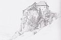
Drawing by Markus PernhartDeutsch:
Zeichnung von Markus Pernhart -
 English:
Drawing by Markus PernhartDeutsch:
Zeichnung von Markus Pernhart -
 English:
Drawing by Markus PernhartDeutsch:
Zeichnung von Markus Pernhart -
 English:
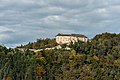
Northwestern viewDeutsch:
NW-Ansicht -
 English:
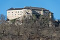
Southwestern viewDeutsch:
SW-Ansicht -
 English:
Southern viewDeutsch:
Süd-Ansicht -
 English:
 Southern viewDeutsch: Süd-Ansicht
 -
 English:
Southern viewDeutsch:
Süd-Ansicht -
 English:
Gate tower's pseudo-facade architecture at the entranceDeutsch:
Scheinfassadenarchitektur am Torturm mit Einfahrt -
 English:
Gate tower's pseudo-facade architecture at the entranceDeutsch:
Scheinfassadenarchitektur am Torturm mit Einfahrt -
 English: Gate tower with portalDeutsch: Torturm mit Einfahrt
 -
 English:
PortalDeutsch:
Portal -
 English:
PortalDeutsch:
Portal -
 English:
Northern viewDeutsch:
Nord-Ansicht -
 English:
Northern viewDeutsch:
Nord-Ansicht -
 English:
Northern viewDeutsch:
Nord-Ansicht -
 English:
Northern viewDeutsch:
Nord-Ansicht -
 English:
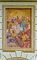
Sacra Conversazione on the gate towerDeutsch:
Sacra Conversazione am Torturm -
 English:
Sacra Conversazione on the gate towerDeutsch:
Sacra Conversazione am Torturm -
 English:
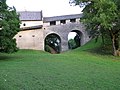
Gate tower, corridor and arch bridge over the neck ditchDeutsch:
Torturm, Gang und Bogenbrücke über den Halsgraben -
 English: Arch bridge over the neck ditchDeutsch: Bogenbrücke über den Halsgraben
 -
 English:
Arch bridge over the neck ditchDeutsch:
Bogenbrücke über den Halsgraben -
 English:
Northern view of castle Hollenburg with the arch bridge over the neck ditchDeutsch:
Nord-Ansicht der Hollenburg mit der Bogenbrücke über den Halsgraben -
 English:
Cut-outDeutsch:
Ausschnitt -
 English:
Cut-outDeutsch:
Ausschnitt -
 English:
Northern viewDeutsch:
Nord-Ansicht


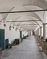
Yard | Burghof edit
-
 English:
Entrance gate to the inner yardDeutsch:
Einfahrtstor zum Innenhof -
 English:
Entrance gate to the inner yardDeutsch:
Einfahrtstor zum Innenhof -
 English:
Staircase at the arcade yardDeutsch:
Treppe im Arkadenhof -
 English:
Staircase at the arcade yardDeutsch:
Treppe im Arkadenhof -
 English:
Staircase at the arcade yardDeutsch:
Treppe im Arkadenhof -
 English:
Arcade yardDeutsch:
Arkadenhof -
 English:
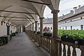
Upper access balconyDeutsch:
Oberer Laubengang -
 English: Upper access balconyDeutsch: Oberer Laubengang
 -
 English:
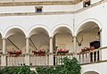
Center part of the upper access balconyDeutsch:
Herzstück des oberen Laubenganges -
 English:
Western part of the upper access balconyDeutsch:
West-Teil des oberen Laubenganges -
 English:
Upper access balconyDeutsch:
Oberer Laubengang -
 English: Upper access balconyDeutsch: Oberer Laubengang
 -
 English:
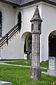
Ancient Roman grave boulder with reliefs of an officer and his man-at-armsDeutsch:
Römerzeitlicher Grabbaublock mit Relief eines Offiziers und seines Waffenknechts -
 English:
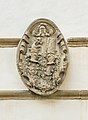
Alliance coat of arms Dietrichstein-StarhembergDeutsch:
Allianzwappen Dietrichstein-Starhemberg im Innenhof -
 English: Alliance coat of arms Dietrichstein-StarhembergDeutsch: Allianzwappen Dietrichstein-Starhemberg im Innenhof
 -
 English:
Ancient Roman grave altar for the couple C. Priscius Surio and SeptimiaDeutsch:
Römerzeitlicher Grabaltar für das Ehepaar C. Priscius Surio und Septimia -
 English:
Relief of a scrivenerDeutsch:
Relief mit Schreiberdarstellung -
 English: Ancient Roman grave altar for the couple C. Priscius Surio and SeptimiaDeutsch: Römerzeitlicher Grabaltar für das Ehepaar C. Priscius Surio und Septimia
 -
 English:
Head of Amon (part of a Roman grave) at the inner yardDeutsch:
Amonskopf (Firstkappe eines römerzeitlichen Grabbaues) im Burghof -
 English:
Head of Amon (part of a Roman grave) at the inner yardDeutsch:
Amonskopf (Firstkappe eines römerzeitlichen Grabbaues) im Burghof -
 English:
Northern wingDeutsch:
Nord-Trakt -
 English:
Southwestern wingDeutsch:
SW-Trakt -
 English:
Southwestern wingDeutsch:
SW-Trakt -
 English:
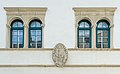
Bifora and alliance coat of arms Dietrichstein-Starhemberg at the arcade yardDeutsch:
Bifora und Allianzwappen Dietrichstein-Starhemberg im Innenhof -
 English:
Ancient Roman grave altar and a portal with overdoorDeutsch:
Römerzeitlicher Grabaltar und ein Portal mit Supraporte -
 English:
Window with closed shutters and inscription aboveDeutsch:
Fenster mit geschlossenen Fensterläden und Inschrift darüber -
 English:
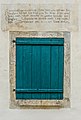
Window with closed shutters and vers from the Bible aboveDeutsch:
Fenster mit geschlossenem Fensterladen und Bibelvers darüber -
 English:
Window with closed shutter and inscription aboveDeutsch:
Fenster mit geschlossenen Fensterläden und Inschrift darüber -
 English:
Detail in the inner yardDeutsch:
Detail im Innenhof


Söller | Balkon edit
Köttmannsdorf edit
| Location: 46°33′40″N 14°13′56″E / 46.56106°N 14.23222°E |
-
 English:
Birthplace of Dr. Primus Lessiak on the Main Road #6Deutsch:
Geburtshaus von Dr. Primus Lessiak an der Hauptstraße 6 -
 English:
Restaurant Ille on Am PlatzDeutsch:
Gasthof Ille Am Platz -
 English:
Farmhouse, Am Platz #4Deutsch:
Bauernhof, Am Platz 4 -
 English:
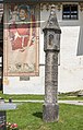
Waysidse shrine on Am PlatzDeutsch:
Bildstock Am Platz -
 English:
Waysidse shrine on Am PlatzDeutsch:
Bildstock Am Platz -
 English:
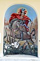
Alcove painting of Saint George from Italy in the wayside shrine on Am PlatzDeutsch:
Nischenbild des Heiligen Georg im Bildstock Am Platz -
 English:
Alcove painting of crucifixion in the wayside shrine on Am PlatzDeutsch:
Nischenbild der Kreuzigung im Bildstock Am Platz -
 English:
Alcove painting of madonna with child in the wayside shrine on Am PlatzDeutsch:
Nischenbild von Madonna mit Kind im Bildstock Am Platz -
 English:
War memorial on Am PlatzDeutsch:
Kriegerdenkmal Am Platz


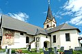
Parish church Saint George | Pfarrkirche Sankt Georg edit
-
 English:
Eastern viewDeutsch:
Ost-Ansicht -
 English:
Southern viewDeutsch:
Süd-Ansicht -
 English:
Southern viewDeutsch:
Süd-Ansicht -
 English:
Northern viewDeutsch:
Nord-Ansicht -
 English:
Southwestern viewDeutsch:
Südwest-Ansicht -
 English:
Southwestern view with light columnDeutsch:
Südwest-Ansicht mit Totenleuchte -
 English:
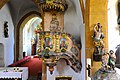
InteriorDeutsch:
Inneres -
 English:
PulpitDeutsch:
Kanzel -
 English:
High altarDeutsch:
Hochaltar -
 English:
OrganDeutsch:
Orgel


Gothic light column | Gotische Totenleuchte edit
-
 English:
Southwestern viewDeutsch:
SW-Ansicht -
 English:
Southwestern viewDeutsch:
SW-Ansicht -
 English:
Southwestern viewDeutsch:
SW-Ansicht -
 English:
Southern viewDeutsch:
Süd-Ansicht -
 English:
Southern viewDeutsch:
Süd-Ansicht -
 English:
Northwestern viewDeutsch:
NW-Ansicht -
 English:
Northeastern viewDeutsch:
NO-Ansicht -
 English:
Northeastern viewDeutsch:
NO-Ansicht


Lambichl edit
-
 English:
Canon in front of the KanonenhofDeutsch:
Kanone vor dem Kanonenhof

Mostitz edit
Neusass edit
Plöschenberg edit
-
 English:
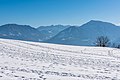
ViewDeutsch:
Ansicht -
 English:
Country restaurant PloeschenbergDeutsch:
Landgasthof Plöschenberg -
 English:
Country restaurant PloeschenbergDeutsch:
Landgasthof Plöschenberg -
 English:
ForestDeutsch:
Wald -
 English:
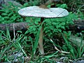
Parasol mushroom in the forestDeutsch:
Parasol-Pilz im Wald -
 English:
Parasol mushroom in the forestDeutsch:
Parasol-Pilz im Wald -
 English:
Barley fieldDeutsch:
Gerstenfeld -
 English:
Barley fieldDeutsch:
Gerstenfeld -
 English:
Barley fieldDeutsch:
Gerstenfeld -
 English:
Barley fieldDeutsch:
Gerstenfeld -
 English:
Karutschnig farmstead, defunct in 1988Deutsch:
Karutschnig-Wiese, im Jahre 1988 aufgelassen -
 English:
Karutschnig meadowDeutsch:
Karutschnig-Wiese -
 English:
Karutschnig meadowDeutsch:
Karutschnig-Wiese


Plöschenberg edit
Miscellaneous | Versciedenes edit
-
 English:
Distribution substationDeutsch:
Verteilertransformator

Views | Aussichten edit
-
 English:
LandscapeDeutsch:
Landschaft -
 English:
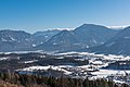
View of Ferlacher Horn and KošutaDeutsch:
Blick auf das Ferlacher Horn und in die Koschuta -
 English:
WaldrandDeutsch:
Edge of the forest -
 English:
View of Rosental and Ferlacher HornDeutsch:
Rosental-Blick mit Ferlacher Horn -
 English:
View of Rosental and Ferlacher HornDeutsch:
Rosental-Blick mit Ferlacher Horn -
 English:
View of Rosental and SingerbergDeutsch:
Rosental-Blick mit Singerberg


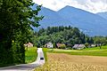
Preliebl edit
Rotschitzen edit
Sankt Gandolf edit
-
 English:
View from PloeschenbergDeutsch:
Blick vom Plöschenberg -
 English:
West viewDeutsch:
West-Ansicht -
 English:
Wayside shrine and west viewDeutsch:
Nischenbildstock und West-Ansicht -
 English:
Subsidiary churchDeutsch:
Filialkirche


Sankt Margarethen edit
-
 English:
Subsidiary churchDeutsch:
Filialkirche -
 English:
Subsidiary churchDeutsch:
Filialkirche -
 English:
Portal of the subsidiary churchDeutsch:
Portal der Filialkirche


Thal edit
-
 English:
Muehlenstrasse #2: Boundary stone between Hollenburg and ViktringDeutsch:
Mühlenstraße 2: Grenzstein zwischen Hollenburg und Viktring -
 English:
Muehlenstrasse #2: Boundary stone between Hollenburg and ViktringDeutsch:
Mühlenstraße 2: Grenzstein zwischen Hollenburg und Viktring -
 English:
Thalhof millDeutsch:
Thalhof Mühle -
 English:
Thalhof millDeutsch:
Thalhof Mühle


Trabesing edit
-
 English:
Wayside shrineDeutsch:
Bildstock

Tretram edit
Tschachoritsch edit
Maria Waldesruh edit
-
 English:
Forest chapelDeutsch:
Waldkapelle -
 English:
Forest chapelDeutsch:
Waldkapelle -
 English:
Forest chapelDeutsch:
Waldkapelle


Tschrestal edit
-
 English:
Number 5: Farmstead family MischkulingDeutsch:
Nummer 5: Bauernhof Familie Mischkulnig -
 English:
Number 2: vulgo Hlabin, set up in 1936Deutsch:
Nummer 2: vulgo Hlabin, erbaut im 1936 -
 English:
Number 2: vulgo Hlabin, snack bar ClaudiaDeutsch:
Nummer 2: vulgo Hlabin, Buschenschänke Claudia -
 English:
Number 2: vulgo Hlabin, snack bar ClaudiaDeutsch:
Nummer 2: vulgo Hlabin, Buschenschänke Claudia -
 English:
Number 2: vulgo Hlabin, snack bar ClaudiaDeutsch:
Nummer 2: vulgo Hlabin, Buschenschänke Claudia


Unterschlossberg edit
Loiblpass Strasse B91 edit
-
 English:
Road bridgeDeutsch:
Strassenbrücke -
 English:
Road bridgeDeutsch:
Strassenbrücke -
 English:
Road bridgeDeutsch:
Strassenbrücke -
 English:
Road bridgeDeutsch:
Strassenbrücke -
 English:
Road bridgeDeutsch:
Strassenbrücke -
 English:
  Road bridgeDeutsch: Strassenbrücke
 -
 English:
Road bridgeDeutsch:
Strassenbrücke -
 English:
Road bridgeDeutsch:
Strassenbrücke -
 English:
Road bridgeDeutsch:
Strassenbrücke -
 English:
Road bridgeDeutsch:
Strassenbrücke -
 English:
Road bridgeDeutsch:
Strassenbrücke -
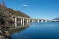
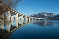
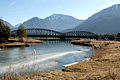
 English:
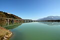
Road bridge of the B91 across the DravaDeutsch:
Strassenbrücke der B91 über den Ferlacher Stausee -
 English:
Road bridgeDeutsch:
Strassenbrücke


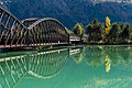
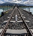
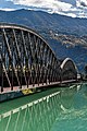
Rosentalbahn II edit
-
 English:
Railway bridgeDeutsch:
Eisenbahnbrücke -
 English:
Railway bridgeDeutsch:
Eisenbahnbrücke -
 English:
Railway bridgeDeutsch:
Eisenbahnbrücke -
 English:
Railway bridgeDeutsch:
Eisenbahnbrücke -
 English:
Railway bridgeDeutsch:
Eisenbahnbrücke -
 English:
Railway bridgeDeutsch:
Eisenbahnbrücke -
 English:
Railway bridgeDeutsch:
Eisenbahnbrücke -
 English:
Railway bridgeDeutsch:
Eisenbahnbrücke -
 English:
Railway bridgeDeutsch:
Eisenbahnbrücke -
 English:
Railway bridgeDeutsch:
Eisenbahnbrücke -
 English:
Railway bridgeDeutsch:
Eisenbahnbrücke


On the reservoir | Am Stausee edit
-
 English: Northern viewDeutsch: Nord-Ansicht
 -
 English:
Northern viewDeutsch:
Nord-Ansicht -
 English:
Eastern viewDeutsch:
Ost-Ansicht -
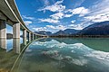
 English:
Boat harborDeutsch:
Bootshafen -
 English:
Boat harborDeutsch:
Bootshafen


Wegscheide edit
Meierhof | Administrator's building edit
-
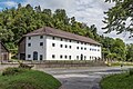 English:
Southern viewDeutsch:
Süd-Ansicht -
 English: Southern viewDeutsch: Süd-Ansicht


Miscellaneous | Diverses edit
-
 English:
Northeastern viewDeutsch:
NO-Ansicht -
 English:
Loiblpass street, side road to the HollenburgDeutsch:
Loiblpass Strasse, Abzweigung zur Hollenburg


Wurdach edit
Views | Ansichten edit
-
 English:
Eastern viewDeutsch:
Ost-Ansicht -
 English:
GazeboDeutsch:
Aussichtspunkt -
 English:
GazeboDeutsch:
Aussichtspunkt -
 English:
Tree stumps of apple treesDeutsch:
Baumstümpfe von Apfelbäumen


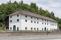
No. 2: Farm building | Nr. 2: Wirtschaftsgebäude edit
-
 English:
Northeastern viewDeutsch:
NO-Ansicht

No. 53: Farm | Nr. 53: Bauernhof edit
-
 English:
Southwestern viewDeutsch:
SW-Ansicht

Miscellaneous | Diverses edit
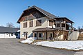
-
 English:
Fire stationDeutsch:
Feuerwehrhaus -
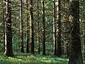 English:
ForestDeutsch:
Wald -
 English:
Woodpile of logsDeutsch:
Blochstapel -
 English:
Forest trailDeutsch:
Naturlehrpfad Zwergohreule


