Landwehrkanal
canal in Berlin, Germany
canal in Berlin, Germany    | |||||
| Upload media | |||||
| Instance of |
| ||||
|---|---|---|---|---|---|
| Named after | |||||
| Location | |||||
| Connects with | |||||
| Heritage designation | |||||
| Inception |
| ||||
| Date of official opening |
| ||||
| Elevation above sea level |
| ||||
| Mouth of the watercourse | |||||
| Drainage basin | |||||
| Tributary | |||||
 | |||||
English: The Landwehrkanal connects the upper part with the lower part of river Spree. It was built between 1845 and 1850 and flows through Berlin-Charlottenburg, Berlin-Tiergarten and Berlin-Kreuzberg (main part). In Kreuzberg a long part of the Landwehrkanal is accompanied by the Berlin U-Bahn, which runs here as an elevated railway. See also: Category:Bridges over the Landwehrkanal in Berlin
Deutsch: Der Landwehrkanal aus den Jahren 1845/1850 verbindet die obere Spree mit der unteren Spree und durchfließt die Stadtteile Charlottenburg, Tiergarten und Kreuzberg (Hauptteil). In Kreuzberg wird ein langes Teilstück von der U-Bahnlinie 1 begleitet, die hier als Hochbahn verläuft. Die Ausbuchtung des „Urbanhafen“ ist ein historisches Relikt eines rückgebauten Hafens. Am Urbanhafen zweigte der ehemalige Luisenstädtische Kanal ab, der 1926 zugeschüttet wurde. Siehe auch: Brücken über den Landwehrkanal
Maps edit
-
 Berlin city wall (1855) with the canal in the south, then outside the city of Berlin
 -
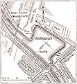
 Urbanhafen and Luisenstädtischer Kanal. The isle ("Ladeinsel") within the harbour doesn't exist anymore. The marking indicates the St.-Michaels-Kirche.
 -
 Former "Schöneberger Hafen" (harbour) 1896


Charlottenburg edit
-
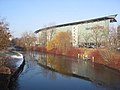
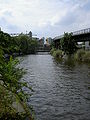
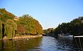
 River Spree at mouth of Landwehrkanal
 -
 “Dovebrücke“, built in 1911 (first bridge towards east)
 -
 Detail stonework “Dovebrücke“, built in 1911
 -
 Park beside “Marchbrücke“
 -
 “Marchbrücke“, built in 1911, with historical tower-house
 -
 “Marchbrücke“, built in 1911, with historical sandstone-portal
 -
 View from „Charlottenbrücke“ of en:Straße des 17. Juni, (de:Straße des 17. Juni) to „Salzufer“ with „Mercedes-Benz“ head office in Berlin


Tiergarten edit
-
 Schleuseninsel (Lockisle) near „Charlottenbrücke“ of en:Straße des 17. Juni, (de:Straße des 17. Juni), restaurant-ship and cavitation tunnel / Restaurant-Schiff und Kavitationstunnel der „Versuchsanstalt für Wasserbau und Schiffbau“ (VWS)
 -
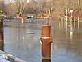
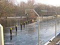
 the same with ice
 -
 Schleuseninsel – Kavitationstunnel der Versuchsanstalt für Wasserbau und Schiffbau (VWS) / cavitation tunnel
 -
 VWS
VWS -
 VWS
VWS -
 VWS
VWS -
 “Unterschleuse“ (lock) Tiergarten with S-Bahn
 -
 “Unterschleuse“ (lock) Tiergarten with train
 -
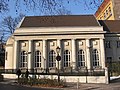
 “Versuchsanstalt für Wasserbau und Schiffbau“ at “Unterschleuse“ (lock) Tiergarten
 -
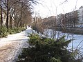
 Near “Unterschleuse“ (lock) with view to park de:Großer Tiergarten
 -
 dto.
dto. -
 dto.
dto. -
 Impression close to lower lock
 -
 S-Bahn-bridge over sidearm around Lockisle / S-Bahnbrücke über den Seitenarm um die Schleuseninsel, Schiff „Volldampf“ des „Deutschen Technikmuseum Berlin“
 -
 dto.
dto. -
 dto., and historical ornament at pier
 -
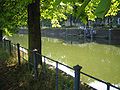 Lützowufer, close to Lützowplatz


Potsdamer Platz, Reichpietschufer edit
Reichpietschufer and Schöneberger Ufer (opposite) belong with her main parts to Tiergarten and with the rest to Kreuzberg. At Potsdamer Platz runs the border between the two districts.
-
 Reichpietschufer, beside Potsdamer Platz
 -
 dto.
dto. -
 dto.
dto. -
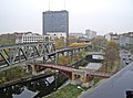
 Reichpietschufer/Schöneberger Ufer, view to „Köthener Brücke“ and bridge for U-Bahn-2


Hallesches Ufer, Tempelhofer Ufer (Kreuzberg) edit
-
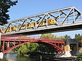
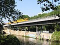
 U-Bahn train crossing the Landwehrkanal and the old bridge of the former Berlin-Anhaltische railway
 -
 U-Bahn train crossing the Landwehrkanal and ...
 -
 U-Bahn train crossing the Landwehrkanal and the bridge of the Berlin-Anhaltische railway around 1900
 -
 Möckernbrücke
 -
 Möckernbrücke
 -
 Hallesches Tor (station, U1)
 -
 Hallesches Tor Bridge
 -
 Near Möckernbrücke
 -
 Anhalter Steg
 -
 Anhalter Steg 2008


Waterlooufer, Carl-Herz-Ufer edit
-
 U-Bahn at Waterlooufer
 -
 Promenade at "Sommerbad Prinzenstraße", across from Carl-Herz-Ufer


Urbanhafen (Kreuzberg) edit
-
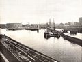 Urbanhafen around 1900
 -
 Urbanhafen, bank between Segitzdamm and Erkelenzdamm. This place was up to 1926 the mouth of Luisenstädtischer Kanal, which was reworked afterwards into a park.
 -
 dto.
dto. -
 The same place, swans on frozen water
 -
 View to the south bank with restaurant-boats and street „Planufer“
 -
 Fraenkelufer seen from the water
 -
 Fraenkelufer at Urbanhafen, view from Admiralbrücke
 -
 Restaurant-boat, opposite Fraenkelufer
 -
 Map Böcklerpark with Urbanhafen


Fraenkelufer, Planufer (Kreuzberg) edit
Between Urbanhafen and Kottbusser Brücke/Paul-Lincke-Ufer/Maybachufer is situated the Fraenkelufer and opposite on the south bank the Planufer
-
 Fraenkelufer at Admiralbrücke
 -
 Fraenkelufer/Corner Admiralstraße
 -
 Fraenkelufer, orthodox synagogue
 -
 Fraenkelufer, orthodox synagogue


Paul-Lincke-Ufer, Maybachufer (Kreuzberg) edit
-
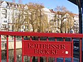 View from „Kottbusser Brücke“ to „Paul-Lincke-Ufer“
 -
 View from Kottbusser Brücke direction of Neukölln
 -
 Residential houses by Wilhelminian style
 -
 ...the same house, detail
 -
 Residential house by Wilhelminian style
 -
 ...the same house, detail at roof
 -
 Water front
 -
 Cathedral of electricity, listed transforming station, built in 1924/28 / de: Denkmalgeschütztes ehemaliges Umspannwerk Paul-Lincke-Ufer, gebaut 1924/28 von Heinrich Müller. Im Berliner Volksmund: Kathedrale der Elektrizität.
 -
 View east from the Ohlauer Brücke


Last part, Oberschleuse, Lohmühleninsel edit
In his last part in the Landwehrkanal is situated the de:Lohmühleninsel, the east side of the canal is called "Flutgraben". His north part flows at Oberschleuse (lock) to river Spree. The part belongs also to Kreuzberg, at the border to Berlin Alt-Treptow.
-
 Thielenbrücke at the border to Neukölln
 -
 Heckmannufer (opposite Lohmühleninsel)
 -
 Lohmühleninsel, Treptower Brücke
 -
 Treptower Brücke and Flutgraben
 -
 Flutgraben with houseboats
 -
 ehemaliges Steuerhaus der Wasserbauinspektion, diente der Einnahme der Akzise
 -
 Oberschleuse (the "upper" lock) seen from Schlesische Brücke
 -
 dto. in winter, river Spree in the background
 -
 dto., on the right Lohmühleninsel
 -
 Alfred and Gustav Felix Flatow memorial plaque at the Flatow sports hall
 -
 First petrol station (2003)
 -
 First petrol station with motor service area in Berlin from 1928/29 (listed) (2005)
 -
 Lohmühleninsel, Cutout from Pharus-Plan 1902.
 -


Varia edit
-
 Lohmühlenbrücke über den Neuköllner Schiffahrtskanal an seiner Mündung in den Landwehrkanal

Art & Memorial edit
-
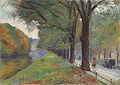 Lesser Ury: Am Landwehrkanal im Herbst
 -
 Artwork at „Einsteinufer“, Charlottenburg
 -
 Graffiti at Stadthaus Böcklerpark (Prinzenstraße), close to Urbanhafen
 -
 Memorial to Rosa Luxemburg, close to lower lock, Berlin-Tiergarten
 -
 Plaque
 -
 Plaque


_Landwehrkanal.jpg)
_Landwehrkanal_Regen%C3%BCberlauf.jpg)