Maps of Amersfoort
English: Maps of Amersfoort
Nederlands: Kaarten van Amersfoort
Deutsch: Karten von Amersfoort
Français : Cartes de Amersfoort
Chronological
editCity
edit-
 ± 1570
 -
 1588
1588 -
 1649
1649 -
 1652
1652 -
 1657
1657 -
 ± 1698
 -
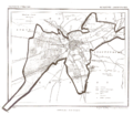
 1846
1846 -
 1888
1888 -
 2014
2014
.png)

.jpg)


Municipality
edit-
 Amersfoort, 1865
 -
 Hoogland, 1868
 -
 2009
2009 -
 2012
2012 -
 2015
2015


.svg)


Details
edit-
 2014, city centre
 -
 2016, Langestraat
 -
 Rijksbeschermd gezicht (protected area) Amersfoort
 -
 Rijksbeschermd gezicht (protected area) Bergkwartier


Region
edit-
 1617
1617 -
 2015, with altitude lines


Locator maps
edit-
 2006
2006 -
 2016
2016

.png)
Neighborhoods
edit-
 North
North -
 Middle
 -
 South
South


Other
edit-
 Plaque showing the city around 1580
