Maps of Ireland
Countries of Europe: Albania · Andorra · Armenia‡ · Austria · Azerbaijan‡ · Belarus · Belgium · Bosnia and Herzegovina · Bulgaria · Croatia · Cyprus‡ · Czech Republic · Denmark · Estonia · Finland · France‡ · Georgia‡ · Germany · Greece · Hungary · Iceland · Republic of Ireland · Italy · Kazakhstan‡ · Latvia · Lithuania · Luxembourg · Malta · Monaco · Netherlands‡ · North Macedonia · Norway · Poland · Portugal‡ · Romania · Russia‡ · San Marino · Slovakia · Slovenia · Spain‡ · Sweden · Switzerland · Turkey‡ · Ukraine · United Kingdom · Vatican City
Specific status: Faroe Islands · Gibraltar · Isle of Man – Limited recognition: Abkhazia‡ · Kosovo
‡: partly located in Europe
Specific status: Faroe Islands · Gibraltar · Isle of Man – Limited recognition: Abkhazia‡ · Kosovo
‡: partly located in Europe
- Maps are also available as part of the
 Wikimedia Atlas of the World project in the Atlas of Ireland.
General maps edit
-
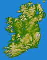
 Physical map of Ireland
 -
 Topographic map of Ireland
 -
 Map of Ireland from CIA World Factbook
 -
 Memec map


Locator maps edit
-
 Location of the island of Ireland
 -
 Location of the Republic of Ireland
 -
 Location of the Republic of Ireland in Europe


Provinces edit
-
 Historical provinces of Ireland
 -
 Province Connacht
 -
 Province Leinster
 -
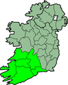 Province Munster
 -
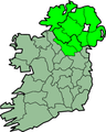 Province Ulster


Counties edit
italics denote non-administrative counties
† denote Northern Irish counties
Highlighted in the nation edit
-
 Counties of Ireland
 -
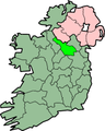
 County Antrim†
 -
 County Armagh†
 -
 County Carlow
 -
 County Cavan
 -
 County Clare
 -
 County Cork
 -
 County Donegal
 -
 County Down†
 -
 County Dublin
 -
 County Fermanagh†
 -
 County Dun Laoghaire-Rathdown
 -
 County Fingal
 -
 County South Dublin
 -
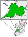
 County Galway
 -
 County Kerry
 -
 County Kilkenny
 -
 County Laois
 -
 County Leitrim
 -
 County Limerick
 -
 County Londonderry†
 -
 County Meath
 -
 County Tipperary
 -
 County Tyrone†
 -
 County Wexford
 -
 County Wicklow


Single counties edit
-
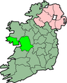
 County Cork
 -
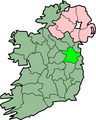
 County Donegal
 -
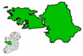
 County Dublin with Dublin city highlighted
 -
 County Galway
 -
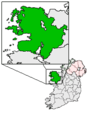
 County Kildare
 -
 County Limerick
 -
 County Westmeath


Counties magnified edit
-
 County Carlow
 -
 County Cavan
 -
 County Clare
 -
 County Cork
 -
 County_Donegal
 -
 County Dublin
 -
 County Dun Laoghaire-Rathdown
 -
 County Fingal
 -
 County Galway
 -
 County Kerry
 -
 County Kildare
 -
 County Kilkenny
 -
 County Laois
 -
 County Leitrim
 -
 County Limerick
 -
 County Longford
 -
 County Louth
 -
 County Mayo
 -
 County Meath
 -
 County Monaghan
 -
 County Offaly
 -
 County Roscommon
 -
 County Sligo
 -
 County South Dublin
 -
 County Tipperary
 -
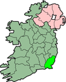
 County Waterford
 -
 County Westmeath
 -
 County Wexford
 -
 County Wicklow


Other places edit
-
 Clare Island
 -
 Lough Corrib


Linguistic maps edit
-
 Irish speakers in 2011 census
 -
 Irish speakers in 1871

