Maps of Norway
Countries of Europe: Albania · Andorra · Armenia‡ · Austria · Azerbaijan‡ · Belarus · Belgium · Bosnia and Herzegovina · Bulgaria · Croatia · Cyprus‡ · Czech Republic · Denmark · Estonia · Finland · France‡ · Georgia‡ · Germany · Greece · Hungary · Iceland · Republic of Ireland · Italy · Kazakhstan‡ · Latvia · Liechtenstein · Lithuania · Luxembourg · Malta · Moldova · Monaco · Montenegro · Netherlands‡ · North Macedonia · Norway · Poland · Portugal‡ · Romania · Russia‡ · San Marino · Serbia · Slovakia · Slovenia · Spain‡ · Sweden · Switzerland · Turkey‡ · Ukraine · United Kingdom · Vatican City
Specific status: Akrotiri and Dhekelia‡ · Faroe Islands · Gibraltar · Bailiwick of Guernsey · Isle of Man · Jersey · Svalbard – Limited recognition: Abkhazia‡ · Gagauzia · Kosovo · South Ossetia‡ · Transnistria · Northern Cyprus‡ · United Nations Buffer Zone in Cyprus‡
‡: partly located in Europe
Specific status: Akrotiri and Dhekelia‡ · Faroe Islands · Gibraltar · Bailiwick of Guernsey · Isle of Man · Jersey · Svalbard – Limited recognition: Abkhazia‡ · Gagauzia · Kosovo · South Ossetia‡ · Transnistria · Northern Cyprus‡ · United Nations Buffer Zone in Cyprus‡
‡: partly located in Europe
- Maps are also available as part of the
 Wikimedia Atlas of the World project in the Atlas of Norway.
-
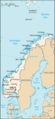
 Location map for Norway
 -
 Map of Norway with Svalbard and Bjørnøya
 -
 Map of the mainland of Norway
 -
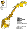
 Map of the mainland of Norway with Norwegian caption
 -
 Satellite image of Norway in February 2003


Location maps edit
Location maps are available for all the counties (fylker) and some of the municipalities. They all have the same name syntax. Image:Name kart.png where name is the name of the place. Some of the filenames contain special characters, like æ, ø and å.
Maps of the counties (2017) edit
-
 SVG map based on the following two maps
 -
 Blank map
 -
 Location of Akershus
 -
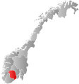
 Location of Aust-Agder
 -
 Location of Buskerud
 -
 Location of Finnmark
 -
 Location of Hedmark
 -
 Location of Hordaland
 -
 Location of Møre og Romsdal
 -
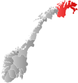
 Location of Nordland
 -
 Location of Nord-Trøndelag
 -
 Location of Oppland
 -
 Location of Oslo
 -
 Location of Rogaland
 -
 Location of Sogn og Fjordane
 -
 Location of Sør-Trøndelag
 -
 Location of Telemark
 -
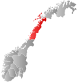
 Location of Troms
 -
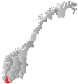 Location of Vest-Agder
 -
 Location of Vestfold
 -
 Location of Østfold


