Old maps of cities
Old maps are included in the ![]() Wikimedia Atlas
Wikimedia Atlas ![]() .
.
Africa/Afrique edit


The Americas/Las Américas edit
-
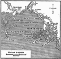 Historical map of Montevideo (1888)
 -
 Historical map of Valparaíso (1888)
 -
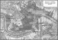
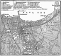
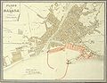
 Historical map of Havana (1888)
 -
 Historical map of Buenos Aires (1888)


Brazil/Brasil edit
-
 Historical map of Rio de Janeiro (1888)
 -
 Historical map of Salvador da Bahia (1888)


Mexico/México edit
-
 Historical map of Oaxaca de Juárez (1877)

Peru/Perú edit


United States/Estados Unidos edit
-
 Historical map of Baltimore (1888)
 -
 Historical map of Boston/Massachusetts (1888)
 -
 Historical map of Honolulu (1888)
 -
 Historical map of New Orleans (1888)
 -
 Historical map of Philadelphia/Pennsylvania (1888)
 -
 Historical map of San Francisco (1888)
 -
 Historical map of Washigton D.C. (1888)
 -
 Salem Village, Massachusetts (1692)
 -
 Historical Map of Williamsburgh, Brooklyn (1827)
 -
 Historical Map of Williamsburgh, Brooklyn (1845)

.jpg)


Asia edit
-
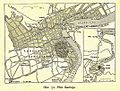
 Historical map of Bangkok
 -
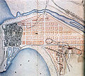
 Historical map of Jakarta (Batavia)
 -
 Historic map of Delhi, 1863
 -
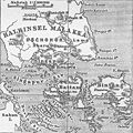 Historical map of Singapur
 -
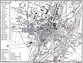
 Historical map of Tokyo
 -
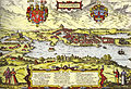
 Historical map of Constantinople (1493)
 -
 Historical map of Hanoi
 -
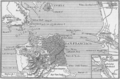
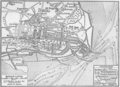
 Historical map of Vladivostok when seized by the Czechoslovak Legions on 29 June 1918


China/中国 edit
-
 Historical map of Shanghai
 -

-
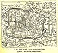
 Historical map of Beijing
 -
 Historical map of Shanghai
 -
 Historical map of Chengdu
 -
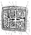
 Historical map of Lhasa


India/भारत edit
.jpg)
.jpg)
.jpg)


Europe edit
-
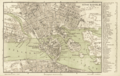
 London 1720
 -
 Historical map of Klagenfurt (c. 1735)
 -
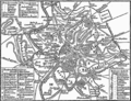
 Historical map of Lisbon (1888)
 -
 Historical map of Pula (Pola) (1888)
 -
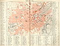
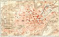
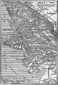
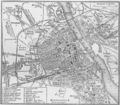
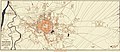
 Historical map of Vienna (1888)
 -
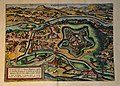 Oradea by Braun & Hogenberg (1617)
 -
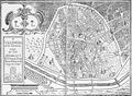
 Paris 1880


Belgium/België/Belgique/Belgien edit
-
 Historical map of Antwerpen (1888)
 -


Czech Republic/Česká republika edit
-
 Historical map of Kolín (1640)

France edit
-

-
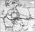
 Historical map of Brest
 -
 Historical map of Brest
 -
 Historical map of Brest
 -
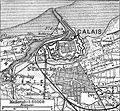 Historical map of Calais
 -
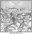 Historical map of Cherbourg
 -
 Historical map of Le Havre
 -
 Historical map of Marseilles
 -
 Historical map of Strasbourg
 -
 Historical map of Toulouse
 -
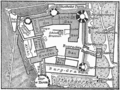
 Historical map of castle Versailles


Germany/Deutschland edit
-
 Historical map of Apolda (1921)
 -
 See also Maps of Berlin
 -
 Historical map of Camburg (1921)
 -
 Historical map of Darmstadt (1888)
 -
 copper-engraving of Dorsten in (1633)
 -
 Siege of Dorsten (1641)
 -
 Historical map of Dresden (1876)
 -
 Historical map of Erfurt (1493)
 -
 Historical map of Hamburg (1660)
 -
 Historical map of the castle Heidelberg (1888)
 -
 Historical map of Heilbronn (1903)
 -
 Historical map of Hildesheim (1910)
 -
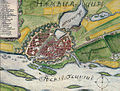
 Maximaler französischer Ausbauplan von Jülich
 -
 Historical map of Leipzig (1876)
 -
 Historical map of Lübeck
 -
 Historical map of Mannheim (1888)
 -

-
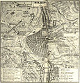
 München (Munich) 1858
 -
 Historical map of Munich (1888)
 -
 Historical map of Naumburg (Saale) (1921)
 -
 Historical map of Neuruppin (1888)
 -
 Historical map of Neustadt an der Donau (1819)
 -
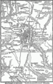
 Nuremberg Nürnberg (1858)
 -
 Historical map of Schleswig
 -
 Historical map of Stuttgart
 -
 Historical map of Stuttgart (1893)
 -
 Historical map of Weinsberg (1914)
 -
 Historical map of Wilhelmshaven (1888)
 -
 Historical map of Wiesbaden


Greece/Ελλάδα edit
-
 Historical map of Athens
 -
 Historical map of Mykene
 -
 Historical map of Pergamon


Ireland/Éire edit
-
 Kilkenny city, by Sam Byron (c. 1780). small version
*Large version for printing
*A PDF version of the large version with JBIG2-lossless compression -
 Historical map of Dublin (1888)
.png)

Italy/Italia edit
-
 Historical map of Palermo
 -
 Historical map of Trieste(1888)
 -
 Historical map of Venice
 -
 Historical map of the Vesuvius
 -
 Historical map of excavations in Pompeij
 -
 Historical map of the Po-delta
 -
 Historical map of Rome with the walls of emperor Aurelianus
 -
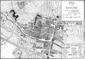
 Plan of Rome in the Middle Ages
 -
 Historical map of La Spezia (1888)


Netherlands/Nederland edit
-
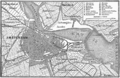 Historical map of Amsterdam (1888)
 -
 Historical map of Rotterdam (1888)
 -
 Historical map of Venlo (1850)


Poland/Polska edit
-
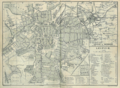
 Historical map of Warsaw
 -
 Historical map of Szczecin (former Stettin)
 -
 Historical map of Bolesławiec (former Bunzlau)
 -
 Lublin in 1783
 -
 Lublin in 1875
 -
 Map of Łódź in 1853

.jpg)
.jpg)
.jpg)
_-_Micha%C5%82_Denar.jpg)

Russia/Россия edit
-
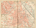
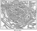
 Historical map of Moscow
 -
 previous image with some higlighting Moskau
 -
 Historical map of St. Petersburg
 -
Historical map of Vladivostok when seized by the Czechoslovak Legions on 29 June 1918


Serbia/Србија edit


Spain/España edit
-
 Historical map of Madrid
 -
 Barcelona, 1859
 -
 Santiago de Compostela, 1595
 -
 Historical map of Cádiz
 -
 Historical map of the Cadiz bay, circa 1813
 -
 Historical map of Salamanca
 -
 Málaga, 1887
 -
 Plano de Medina del Campo en el siglo XVI
 -
 San Sebastián, 1862
 -
 Bilbao, 1857
 -
 Valencia, siglo XVII
 -
 Zaragoza, siglo XVIII


Sweden/Sverige edit
-
 Historical map of Karlskrona (1888)
 -
 Historical map of Karlskrona
 -
 Historical map of Malmö (1580)
 -
 Historical map of Stockholm (1888)
 -
 Historical map of Uppsala (Before the fire 1702)
 -
 Historical map of Uppsala (1770)
 -
 Historical map of Uppsala (1920)


_-_from_Busser,_Om_Upsala_Stad_etc.jpg)
_-_from_Busser,_Om_Upsala_Stad_etc.jpg)

Ukraine/Україна/Украи́на edit


United Kingdom edit


Middle East edit
-
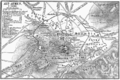
 Historical map of Ephesos
 -
 Historical map of Jerusalem (1888)
 -
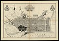
 Historical map of the area surrounding Jerusalem (1888)
 -
 Historical map of Troja


Oceania edit
Australia edit


New Zealand edit
-
 Historical map of Auckland

.png)