User:Morrowlong/gallery
Mon Jun 07 20:53:30 EDT 2010 edit
-
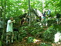
 Paul Mei - Menunkatuck Trail trailblazer for the Connecticut Forest and Park Association (CFPA) and the Guilford Conservation Land Trust (GCLT).
 -
 Participants in the National Trails Day 2010 inaugural Menunkatuck Trail hike sponsored by the Connecticut Forest and Park Association (CFPA), Guilford Conservation Land Trust (GCLT) and the New Haven Hiking Club (NHHC).
 -
 Participants in the National Trails Day 2010 inaugural Menunkatuck Trail hike sponsored by the Connecticut Forest and Park Association (CFPA), Guilford Conservation Land Trust (GCLT) and the New Haven Hiking Club (NHHC).
 -
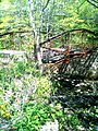
 Vernal pond along the Menunkatuck Trail in the Timberlands near the Iron Stream. Timberlands is forested preserved open space owned by the Town of Guilford Connecticut and managed by the Town's Conservation Committee.
 -
 Vernal pond along the Menunkatuck Trail with flowering lily pads. Timberlands is forested preserved open space owned by the Town of Guilford Connecticut and managed by the Town's Conservation Committee.
 -
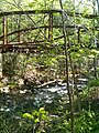
 Bridge on the Menunkatuck Trail in the Guilford Cockaponset forest north of Connecticut Route 80. The Eagle (Boy Scout) stands on his Eagle project.
 -
 Bridge on the Menunkatuck Trail in the Guilford Cockaponset forest north of Connecticut Route 80. The Eagle (Boy Scout) stands on the foundations of his Eagle project.
 -
 Bridge on the Menunkatuck Trail in the Guilford Cockaponset forest north of Connecticut Route 80. The Eagle (Boy Scout) stands on the foundations of his Eagle project. Southern Connecticut State University Astronomy and Meterology Professor and New Haven Hiking Club hike leader Jim Fullmer stands on the bridge on the right.
 -
 On the Menunkatuck Trail near Quonnipaug Lake. Southern Connecticut State University Astronomy and Meterology Professor and New Haven Hiking Club hike leader Jim Fullmer pours cold water into Paul Mei's mouth. Paul Mei is the Guilford Conservation Land Trust and Connecticut Forest and Park Association trailblazer of the Menunkatuck Trail.
 -
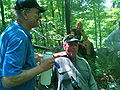 On the Menunkatuck Trail near Quonnipaug Lake. Just after Southern Connecticut State University Astronomy and Meterology Professor and New Haven Hiking Club hike leader Jim Fullmer poured cold water into Paul Mei's mouth. Paul Mei is the Guilford Conservation Land Trust and Connecticut Forest and Park Association trailblazer of the Menunkatuck Trail.


Mon May 03 21:33:22 EDT 2010 edit
-
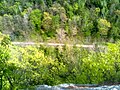
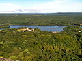
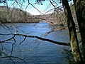
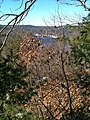 Lake Zoar from the Miller Trail in Upper Kettletown State Park.
 -
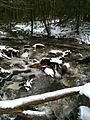
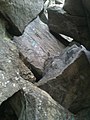
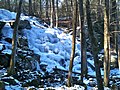 Frozen Prydden Falls above where Prydden Brook waterfalls empty into Lake Zoar.
 -
 Frozen Prydden Falls on the Lake Zoar shore where Prydden Brook waterfalls empty into Lake Zoar.


Mon May 03 17:05:49 EDT 2010 edit
-
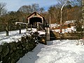
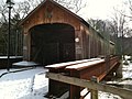 Comstock Covered Bridge from state forest parking lot side.
 -
 Comstock Covered Bridge from state forest parking lot side.
 -
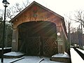
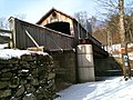
 Comstock Covered Bridge from Salmon River Trail side of bridge. Notice start of Salmon River Blue Blazed trail sign.
 -
 Comstock Covered Bridge from Salmon River Trail side of bridge. Notice start of Salmon River Blue Blazed trail sign.
 -
 Salmon River above the Comstock Bridge as seen from the CFPA Salmon River blue-blazed trail.
 -
 Car wreck in the snow on the CFPA Blue-Blazed Trail Salmon River Trail North Loop (near Day Pond Brook).
 -
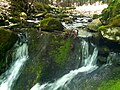
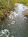
 Snow, ice and water - stream crossing on Salmon River Trail.


Sun May 02 20:16:06 EDT 2010 edit
-
 Condemned Bridge over Hancock Brook, Sheffield Street trailhead, Waterville, Waterbury.

Sun May 02 19:46:50 EDT 2010 edit
-
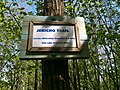
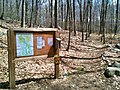
 Signs at Jericho Trail southern terminus on Echo Lake Road.
 -
 Jericho Trail sign at southern terminus on Echo Lake Road.
 -
 Power plant and lines as well as Whitestone Cliffs section of Mattatuck State Forest across CT-8 at Jericho-Whitestone Connector Trail intersection with CT-262.
 -
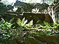
 Ledges with ferns on climb up ravine mid-point on the Jericho Trail.
 -
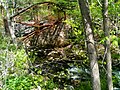
 Jericho Brook waterfall flowing over dam into pool.
 -
 Jericho Brook waterfall flowing over dam into pool.
 -
 Jericho Brook waterfall flowing over dam into pool.
 -
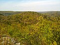 View north from Crane's Lookout.
 -
 View east from Crane's Lookout.
 -
 View northeast from Crane's Lookout.
 -
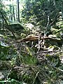
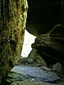
 Leatherman's Cave under Crane's Lookout at Mattatuck and Jericho Trail junction.
 -
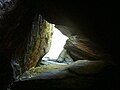 Leatherman's Cave under Crane's Lookout at Mattatuck and Jericho Trail junction.
 -
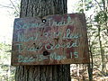
 Jericho Trail head sign at junction with Mattatuck Trail.
 -
 Ruins of Bridge at end of Sheffield Street, Waterbury. Trailhead for Hancock Brook Trail.
 -
 Ruins of Bridge at end of Sheffield Street, Waterbury. Trailhead for Hancock Brook Trail.
 -
 Ruins of Bridge at end of Sheffield Street, Waterbury. Trailhead for Hancock Brook Trail.
 -
 Quarry at end of Sheffield Street in Waterville, Waterbury. Right of way section at beginning of Hancock Brook Trail.
 -
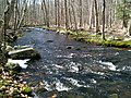
 Hancock Brook on Hancock Brook Trail.
 -
 Hancock Brook on Hancock Brook Trail.
 -
 Hancock Brook on Hancock Brook Trail.
 -
 Scenic view from Lion Head on Hancock Brook Trail.
 -
 Scenic view from Lion Head of railroad on opposite bank of Hancock Brook along the Hancock Brook Trail.
 -
 Scenic view south from Lion Head along the Hancock Brook Trail.
 -
 Scenic view from Lion Head of railroad on opposite bank of Hancock Brook along the Hancock Brook Trail.


Sat May 01 19:41:23 EDT 2010 edit
errors edit
- File:BBHTJHancockBrookTrailBridge1.jpg UnexpectedAnswerException cannot parse uploadwarning location commons:BBHTJHancockBrookTrailBridge1.jpg
-
 Jericho Trail head sign at Echo Lake Road southern terminus.
 -
 Jericho Trail head sign near Echo Lake Road southern terminus.
 -
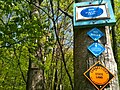
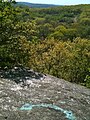 Light blue trail curved blaze with double arrows on rock at viewpoint near Jericho Trail southern terminus.
 -
 Jericho Trail sign at Jericho-Whitestone Connector junction.
 -
 Jericho-Whitestone Connector Trail head sign at Jericho-Whitestone Connector junction with Jericho Trail.
 -
 Power plant and lines as well as Whitestone Cliffs section of Mattatuck State Forest across CT-8 at Jericho-Whitestone Connector Trail intersection with CT-262.
 -
 Light blue with yellow dot trail blazes with double arrows on rock at viewpoint on Jericho-Whitestone Connector Trail at power line cut intersection with CT-262.
 -
 Ravine at mid-point on Jericho Trail.
 -
 Ferns on ledges on climb up ravine at mid-point in Jericho Trail.
 -
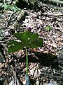
 Wildflower on Jericho Trail.
 -
 Wildflower on Jericho Trail.
 -
 Wildflower on Jericho Trail.
 -
 Wildflower on Jericho Trail.
 -
 Jericho Brook waterfall flowing over dam into pool.
 -
 Jericho Brook waterfall flowing over dam into pool.
 -
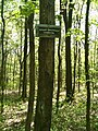
 Mattatuck Trail and Jericho Trail Junction sign.
 -
 Leatherman's Cave under Crane's Lookout at Mattatuck and Jericho Trail junction.
 -
 Leatherman's Cave under Crane's Lookout at Mattatuck and Jericho Trail junction.
 -
 Leatherman's Cave under Crane's Lookout at Mattatuck and Jericho Trail junction.
 -
 Leatherman's Cave under Crane's Lookout at Mattatuck and Jericho Trail junction.
 -
 Ruins of Bridge at end of Sheffield Street, Waterbury. Trailhead for Hancock Brook Trail.
 -
 Trailhead for Hancock Brook Trail at end of Sheffield Street, Waterbury.
 -
Ruins of Bridge at end of Sheffield Street, Waterbury. Trailhead for Hancock Brook Trail.
-
 View of railroad track from Lion Head high point on Hancock Brook Trail.
 -
 View of railroad track from Lion Head high point on Hancock Brook Trail.


Fri Apr 30 21:34:49 EDT 2010 edit
-
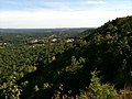 Lamentation Mountain looking north from Lamentation ridge line.
 -
 Silver Lake viewed from Lamentation Mountain.
 -
 Crescent Lake (Bradley Hubbard Reservoir) at Giuffrida Park in Meriden from the Mattabesett Trail.
 -
 Quarry on east face of Chauncey Peak.
 -
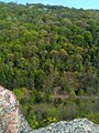
 View from Higby Mountain of the eastern quarry face of Chauncey Peak.
 -
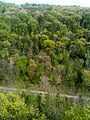
 View from Higby Mountain of Interstate 91 and the eastern quarry face of Chauncey Peak. In the far distance is Lamentation Mountain's long ridge.
 -
 View from Higby Mountain of Interstate 91.


Thu Apr 29 16:22:07 EDT 2010 edit
-
 Gaylordsville Cemetary in Gaylordsville, Connecticut. Housatonic Range Trail northern terminus and parking.
 -
 Housatonic Range CFPA Blue-Blazed Trail in New Milford. Housatonic Range Trail (AKA Candlewood Mtn Trail). "Corkscrew" portion.
 -
 Housatonic Range CFPA Blue-Blazed Trail in New Milford. Housatonic Range Trail (AKA Candlewood Mtn Trail). "Corkscrew" portion.
 -
 Housatonic Range CFPA Blue-Blazed Trail in New Milford.
 -
 Housatonic Range CFPA Blue-Blazed Trail in New Milford. Housatonic Range Trail (AKA Candlewood Mtn Trail). "View" of Housatonic River and Connecticut Route 7 (Kent Rd).


Tue Apr 27 22:49:49 EDT 2010 edit
errors edit
- File:IMG_0571.JPG UnexpectedAnswerException unexpected response data (UiSimpleActionBase) status HTTP/1.0 200 OK
- File:IMG_0572.jpg UnexpectedAnswerException unexpected response data (UiSimpleActionBase) status HTTP/1.0 200 OK
- File:IMG_0573.jpg UnexpectedAnswerException unexpected response data (UiSimpleActionBase) status HTTP/1.0 200 OK
- File:IMG_0574.jpg UnexpectedAnswerException unexpected response data (UiSimpleActionBase) status HTTP/1.0 200 OK
- File:IMG_0575.JPG UnexpectedAnswerException unexpected response data (UiSimpleActionBase) status HTTP/1.0 200 OK
-
Gaylordsville Cemetary in Gaylordsville, Connecticut. Housatonic Range Trail northern terminus and parking.
-
Housatonic Range CFPA Blue-Blazed Trail in New Milford. Housatonic Range Trail (AKA Candlewood Mtn Trail). "Corkscrew" portion.
-
Housatonic Range CFPA Blue-Blazed Trail in New Milford. Housatonic Range Trail (AKA Candlewood Mtn Trail). "Corkscrew" portion.
-
Housatonic Range CFPA Blue-Blazed Trail in New Milford.
-
Housatonic Range CFPA Blue-Blazed Trail in New Milford. Housatonic Range Trail (AKA Candlewood Mtn Trail). "View" of Housatonic River and Connecticut Route 7 (Kent Rd).
-
 Housatonic Range CFPA Blue-Blazed Trail in New Milford. Housatonic Range Trail (AKA Candlewood Mtn Trail). Sign for "Kelly's Slide" side trail.
 -
 Housatonic Range CFPA Blue-Blazed Trail in New Milford. Housatonic Range Trail (AKA Candlewood Mtn Trail). Sign for cave under "Kelly's Slide" on side trail.
 -
 Housatonic Range CFPA Blue-Blazed Trail in New Milford. Housatonic Range Trail (AKA Candlewood Mtn Trail). Cave under "Kelly's Slide" on side trail.
 -
 Housatonic Range CFPA Blue-Blazed Trail in New Milford. Housatonic Range Trail (AKA Candlewood Mtn Trail). Cave under "Kelly's Slide" on side trail.
 -
 Housatonic Range CFPA Blue-Blazed Trail in New Milford. Housatonic Range Trail (AKA Candlewood Mtn Trail). "Kelly's Slide" on side trail.
 -
 Housatonic Range CFPA Blue-Blazed Trail in New Milford. Housatonic Range Trail (AKA Candlewood Mtn Trail). "Kelly's Slide" on side trail.
 -
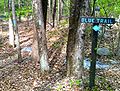 Housatonic Range CFPA Blue-Blazed Trail in New Milford. Housatonic Range Trail (AKA Candlewood Mtn Trail). "Blue Trail" sign on Squash Hollow Road.
 -
 Housatonic Range CFPA Blue-Blazed Trail in New Milford. Housatonic Range Trail (AKA Candlewood Mtn Trail). "Blue Trail" sign on Squash Hollow Road.
 -
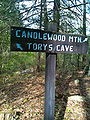 Housatonic Range CFPA Blue-Blazed Trail in New Milford. Housatonic Range Trail (AKA Candlewood Mtn Trail). "Candlewood Mtn to the right and Tory's Cave to tthe left" sign at intersection with Tory's Cave side trail.
 -
 Housatonic Range CFPA Blue-Blazed Trail in New Milford. Tory's Cave on side trail.
 -
 Housatonic Range CFPA Blue-Blazed Trail in New Milford. Tory's Cave sign at Tory's Cave on side trail.
 -
 Housatonic Range CFPA Blue-Blazed Trail in New Milford. Housatonic Range Trail foot bridge near northern terminus.
 -
 Housatonic Range CFPA Blue-Blazed Trail in New Milford. Housatonic Range Trail sign at northern terminus.
 -
 Housatonic Range CFPA Blue-Blazed Trail in New Milford. Housatonic Range Trail sign at northern terminus.


Mon Apr 26 09:26:39 EDT 2010 edit
errors edit
- File:CFPAWhitestoneCliffsTrailView5.jpg UnexpectedAnswerException unexpected response data (UiSimpleActionBase) status HTTP/1.0 200 OK
-
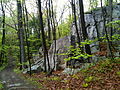
Whitestone Cliffs Trail. Blue-Blazed CFPA "loop" foot path in Mattatuck State Forest. Whitestone Cliffs Trail view of stone cliffs.
Mon Apr 26 09:23:36 EDT 2010 edit
errors edit
- File:CFPAWhitestoneCliffsTrailView5.jpg UnexpectedAnswerException unexpected response data (UiSimpleActionBase) status HTTP/1.0 200 OK
-
Whitestone Cliffs Trail. Blue-Blazed CFPA "loop" foot path in Mattatuck State Forest. Whitestone Cliffs Trail view of stone cliffs.
Mon Apr 26 09:20:40 EDT 2010 edit
-
 Whitestone Cliffs Trail. Blue-Blazed CFPA "loop" foot path in Mattatuck State Forest. Whitestone Cliffs Trail view of stone cliffs.

Mon Apr 26 09:15:34 EDT 2010 edit
errors edit
- File:CFPAWhitestoneCliffsTrailBrook3.jpg UnexpectedAnswerException cannot parse uploadwarning location commons:CFPAWhitestoneCliffsTrailBrook3.jpg
-
 Whitestone Cliffs Trail. Blue-Blazed CFPA "loop" foot path in Mattatuck State Forest. Whitestone Cliffs Trail head sign on Spruce Brook Road / Mt Tobe.
 -
 Whitestone Cliffs Trail. Blue-Blazed CFPA "loop" foot path in Mattatuck State Forest. Whitestone Cliffs Trail head sign on Spruce Brook Road / Mt Tobe.
 -
 Whitestone Cliffs Trail. Blue-Blazed CFPA "loop" foot path in Mattatuck State Forest. Whitestone Cliffs Trail view from high point view.
 -
 Whitestone Cliffs Trail. Blue-Blazed CFPA "loop" foot path in Mattatuck State Forest. Whitestone Cliffs Trail view with seasonal brook.
 -
 Whitestone Cliffs Trail. Blue-Blazed CFPA "loop" foot path in Mattatuck State Forest. Whitestone Cliffs Trail view with seasonal brook.
 -
 Whitestone Cliffs Trail. Blue-Blazed CFPA "loop" foot path in Mattatuck State Forest. Whitestone Cliffs Trail view with seasonal brook.
 -
 Whitestone Cliffs Trail. Blue-Blazed CFPA "loop" foot path in Mattatuck State Forest. Whitestone Cliffs Trail view of stone cliffs.
 -
Whitestone Cliffs Trail. Blue-Blazed CFPA "loop" foot path in Mattatuck State Forest. Whitestone Cliffs Trail view of stone cliffs.
-
 Whitestone Cliffs Trail. Blue-Blazed CFPA "loop" foot path in Mattatuck State Forest. Whitestone Cliffs Trail view of stone/rock summit area.
 -
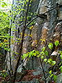 Whitestone Cliffs Trail. Blue-Blazed CFPA "loop" foot path in Mattatuck State Forest. Whitestone Cliffs Trail view of stone cliffs.
 -
 Whitestone Cliffs Trail. Blue-Blazed CFPA "loop" foot path in Mattatuck State Forest. Whitestone Cliffs Trail view of Naugatuck River -- from road walk over Frost Bridge - CT Route 262


Sat Apr 17 20:06:21 EDT 2010 edit
-
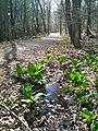
 Forest bog with skunk cabbage mirroring the blue sky and clouds! In Newtown, CT along Aspetuck Valley Trail. Blue-Blazed CFPA foot path in Connecticut Centennial Watershed State Forest which connects to Huntington State Park at the northern terminus and which follows the Aspetuck River from Newtown, CT through Redding and Easton, CT.
 -
 Old abandoned farm stone fence in Centennial State Forest along Aspetuck Valley Trail in Newtown, CT Blue-Blazed CFPA foot path in Connecticut Centennial Watershed State Forest which connects to Huntington State Park at the northern terminus and which follows the Aspetuck River from Newtown, CT through Redding and Easton, CT.
 -
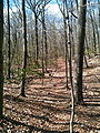 Aspetuck Valley Trail path through woods. near Towne End Road. Blue-Blazed CFPA foot path in Connecticut Centennial Watershed State Forest which connects to Huntington State Park at the northern terminus and which follows the Aspetuck River from Newtown, CT through Redding and Easton, CT.
 -
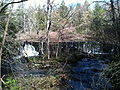 Hedmons Pond waterfall from Aspetuck Valley Trail (Stepney Road walk). Blue-Blazed CFPA foot path in Connecticut Centennial Watershed State Forest which connects to Huntington State Park at the northern terminus and which follows the Aspetuck River from Newtown, CT through Redding and Easton, CT.
 -
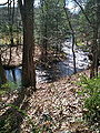 Aspetuck River south of Hedmons Pond waterfall from Aspetuck Valley Trail (Stepney Road walk). Blue-Blazed CFPA foot path in Connecticut Centennial Watershed State Forest which connects to Huntington State Park at the northern terminus and which follows the Aspetuck River from Newtown, CT through Redding and Easton, CT.
 -
 Skunk cabbage in bog along Poverty Hollow Road. Part of Aspetuck Valley Trail road walk in Redding, CT. Blue-Blazed CFPA foot path in Connecticut Centennial Watershed State Forest which connects to Huntington State Park at the northern terminus and which follows the Aspetuck River from Newtown, CT through Redding and Easton, CT.
 -
 Aspetuck Valley Trail. Blue-Blazed CFPA foot path in Connecticut Centennial Watershed State Forest which connects to Huntington State Park at the northern terminus and which follows the Aspetuck River from Newtown, CT through Redding and Easton, CT.
 -
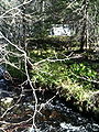
 Aspetuck River - Spring stream with rapids along southern Aspetuck Valley Trail after it leaves Poverty Hollow Road road walk (near end of trail). Blue-Blazed CFPA foot path in Connecticut Centennial Watershed State Forest which connects to Huntington State Park at the northern terminus and which follows the Aspetuck River from Newtown, CT through Redding and Easton, CT.
 -
 Aspetuck Valley Trail. Blue-Blazed CFPA foot path in Connecticut Centennial Watershed State Forest which connects to Huntington State Park at the northern terminus and which follows the Aspetuck River from Newtown, CT through Redding and Easton, CT.


Mon Apr 12 11:26:45 EDT 2010 edit
-
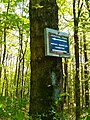
 Pond Brook seasonal scenic trail sign. Lillinonah Trail. Blue-Blazed CFPA foot path which circles the upper Paugussett State Forest (and Lake Lillinonah/Housatonic River) in Newtown, CT.
 -
 Pond Brook inlet. Lillinonah Trail. Blue-Blazed CFPA foot path which circles the upper Paugussett State Forest (and Lake Lillinonah/Housatonic River) in Newtown, CT.
 -
 Al's Trail Association (Newton Trail Association) Newtown Trailway sign on tree on Lillinonah Trail. Blue-Blazed CFPA foot path which circles the upper Paugussett State Forest (and Lake Lillinonah/Housatonic River) in Newtown, CT
 -
 Northern Lake Lillionah from Lillinonah Trail with boat from Blue-Blazed CFPA foot path which circles the upper Paugussett State Forest (and Lake Lillinonah/Housatonic River) in Newtown, CT.
 -
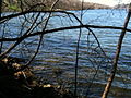 Northern Lake Lillionah from Lillinonah Trail. Blue-Blazed CFPA foot path which circles the upper Paugussett State Forest (and Lake Lillinonah/Housatonic River) in Newtown, CT.
 -
 Northern Lake Lillionah from Lillinonah Trail. Blue-Blazed CFPA foot path which circles the upper Paugussett State Forest (and Lake Lillinonah/Housatonic River) in Newtown, CT.
 -
 Great Oak with vistor's guestbook. Lillinonah Trail. Blue-Blazed CFPA foot path which circles the upper Paugussett State Forest (and Lake Lillinonah/Housatonic River) in Newtown, CT.
 -
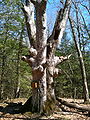 Great Oak with vistor's guestbook. Lillinonah Trail. Blue-Blazed CFPA foot path which circles the upper Paugussett State Forest (and Lake Lillinonah/Housatonic River) in Newtown, CT.
 -
 Great Oak. Lillinonah Trail. Blue-Blazed CFPA foot path which circles the upper Paugussett State Forest (and Lake Lillinonah/Housatonic River) in Newtown, CT.
 -
 Southern Lake Lillionah facing south from Lillinonah Trail. Blue-Blazed CFPA foot path which circles the upper Paugussett State Forest (and Lake Lillinonah/Housatonic River) in Newtown, CT.
 -
 Southern Lake Lillionah facing south from Lillinonah Trail. Blue-Blazed CFPA foot path which circles the upper Paugussett State Forest (and Lake Lillinonah/Housatonic River) in Newtown, CT
 -
 Southern Lake Lillionah facing north from Lillinonah Trail. Blue-Blazed CFPA foot path which circles the upper Paugussett State Forest (and Lake Lillinonah/Housatonic River) in Newtown, CT.
 -
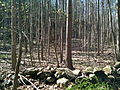 New stand of trees. Lillinonah Trail. Blue-Blazed CFPA foot path which circles the upper Paugussett State Forest (and Lake Lillinonah/Housatonic River) in Newtown, CT.
 -
 Southern Lake Lillinonah facing dam from Lillinonah Trail. Blue-Blazed CFPA foot path which circles the upper Paugussett State Forest (and Lake Lillinonah/Housatonic River) in Newtown, CT.
 -
 Sugarbush - maple sugaring. On Alberts Hill Road. Lillinonah Trail. Blue-Blazed CFPA foot path which circles the upper Paugussett State Forest (and Lake Lillinonah/Housatonic River) in Newtown, CT.
 -
 Sugarbush - maple sugaring. With old stone foundation in background. On Alberts Hill Road. Lillinonah Trail. Blue-Blazed CFPA foot path which circles the upper Paugussett State Forest (and Lake Lillinonah/Housatonic River) in Newtown, CT.


