User:Zde/Minoa Amorgou
< User:Zde
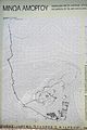
Minoa on Amorgos
| Object location | | View all coordinates using: OpenStreetMap |
|---|
General views
edit-
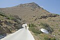 From way from Katapola
 -
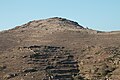
 From Kovaios
 -

-
-
 Katapola Bay from Minoa
 -
 Katapola from Minoa
 -
-

-

-
 From Kato Akrotiri
 -
 From Ag. Georgios Valsamitis
 -
 From Lefkes


Near the entrance
edit


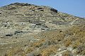
Hellenistic fortification or Gymnasium
editRather the Hellenistic Gymnasium and Roman cistern?


Hellenistic town
editHellenistic Gate
edit


Hellenistic temples and houses
edit
_091310.jpg)
_091328.jpg)
_091309.jpg)
Hellenistic Temple of Apollo
edit_091308.jpg)

On the way to the top
edit


8th century fortification
editOr rather Geometric Age wall (10th to 8th century fortification) and 10th century settlement


On the top
edit


Early Cycladic shrine
editNear top of Minoa, shrine since 4th millennium to the 4th century BC.


Hellenistic and Roman buildings
edit


Findings from Minoa
edit


Kovaios
edit| Object location | | View all coordinates using: OpenStreetMap |
|---|
Katoikia (old country houses) of Kovaios - Livanos, restoration 2002-2003 (Stavros S. Niarchos Foundation)


