User:Zde/Tiryns
< User:Zde
TIryns
Tiryns edit
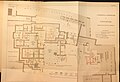
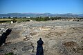
Main Archaeological site
-
 Schliemann 1884
 -
 Dörpfeld 1884
 -
 1898
1898 -

-

-

-


.jpg)


Main Gate edit
| Object location | | View all coordinates using: OpenStreetMap |
|---|
-
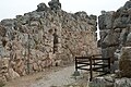 Before the gate
 -
 Gate
Gate -

-

-

-
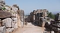 Looking back
 -
 Route to the acropolis


Gallery edit
| Object location | | View all coordinates using: OpenStreetMap |
|---|
Corridor in the south wall


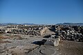
Upper Citadel edit


Palace at Tiryns edit
Akropolis, Megaron
-

-

-
-

-
 Fireplace
 -

-
-

-

-
 Doors
Doors -

-
-


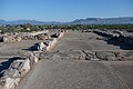
Lower Citadel edit


West Gate edit
| Object location | | View all coordinates using: OpenStreetMap |
|---|


West Walls edit


Tholos tomb edit
| Object location | | View all coordinates using: OpenStreetMap |
|---|


Mycenaean Dam edit
| Object location | | View all coordinates using: OpenStreetMap |
|---|
14th century BC Dam


_-_panoramio.jpg)

Findings from Tiryns edit
Eraly Bronze Age edit

Early Helladic edit
Early Bronze Age (EH II, 2700-2200 BC), mostly at the Lower Citadel
-
 Stone weights
 -
 Sealings
 -
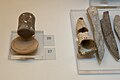 Marble mortar
 -
 Rom of hearth


Early Cycladic edit
Early Bronze Age (EC II-III), Lower Citadel
-
 Cycladic “frying-pan”, 2700-2200 BC
 -
 Stone pyxis, 2200-2000 BC


Mycenaean edit
Late Bronze Age
Pottery edit
-
 Krater, 14th century BC
 -
 Stand, 1350-1250 BC
 -
 Storage stirrup jar, 13th c BC
 -
 13th century BC
 -
 1250-1180 BC
 -
 Tripod gridle tray, 1250-1180 BC
 -
 Krater fragment, wariors on chariot, 1180-1050 BC
 -
 1180-1050 BC


Figurines edit
-
 ”Bird Goddesses”, 1400-1050 BC
 -

-
 Louvre CA 589, 1280 BC
 -
 Louvre CA 591, 13th c BC
 -
 12th century BC
 -

-

-


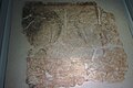
Linear B tablets edit
-
 Lower town, 13-12th c. BC

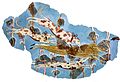
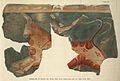
Mycenaean Frescoes edit
14th and 13th century BC
-

-

-
-

-

-
 1200 BC
 -
-
 Plastered floor, 13th c BC

.jpg)


Submycenaean edit
Late Bronze Age / Early Iron Age, 11th and 10th century BC
-
 Bronze helmet, 1050-1025 BC
 -
 1100-1025 BC
 -
 1050-1025 BC
 -
 1025-900 BC
 -
 Amphoriskos
 -
 Amphoriskos
 -
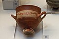
 Skyphos
 -
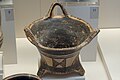 Kalathos
 -
 Skyphos


Archaic Greek period edit
8th to 6th century BC
-
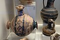 Barrel oinochoe, 750-730 BC
 -
 Krater, 730-690 BC
 -
 7th and 6th century BC
 -

-

-


Votive shield edit
Terracotta, early 7th century BC


