User talk:Pechristener/archives 2
| This is an archive of past discussions. Do not edit the contents of this page. If you wish to start a new discussion or revive an old one, please do so on the current talk page. |
Gruss
.jpg)
Peter, liebe Grüsse aus Franschhoek.
- Nachträglich vielen Dank für den Gruss.--Pechristener (talk) 08:46, 9 May 2022 (UTC)
Mining maps of Western Australia
Hi Pechristener, I'm looking at some decade-old primitive mining maps I created and wondered if it was possible to replace them with the type of OSM map you have created for the iron ore mines. The maps are:
- File:Gold mines Kalgoorlie Leonora.jpg
- File:Gold mines Kalgoorlie.jpg
- File:Gold mines Leonora.jpg
- File:Gold mines Meekathara Leinster.jpg
- Apart from their basicness, the maps could also do with an update. I'm looking at Maperitive right now, which you used for File:Iron ore Pilbara 2.svg, to see if I can get anywhere with it (never used it before). I know its a big ask but if you are at all interested and have time to create new maps, the above ones would certainly be used in the articles of the mines on Wikipedia. As far as what mines are to go on what maps and coordinates, I can certainly provide a list for those. Like I said, only if your interested and got time. Calistemon (talk) 04:48, 29 April 2022 (UTC)
- Yes, maps can be done. I know, Maperitive is a bitch, put it is quite powerful and once you get used to it, it works fine.
- If you wnat to do some preparatin work, you can deliver the coordinates of all the point features in the following form.
name, latitude, longitude- ... and than just insert it here in the discussion. It's not mandatory or a pre-requisit. I get it also done without this. Pechristener (talk) 08:25, 29 April 2022 (UTC)
- Here is a list of sites and coordinates, based on en:User:Calistemon/sandbox, which was compiled by Listeriabot from Wikidata:
| Article | description | Place | coordinate location | product or material produced | ||||
|---|---|---|---|---|---|---|---|---|
| en:Agnew Gold Mine | gold mine in Western Australia | en:Western Australia |
|
en:gold | ||||
| Andy Well Gold Mine | gold mine in Western Australia | en:Western Australia |
|
en:gold | ||||
| en:Beta Hunt Mine | nickel and gold mine in Western Australia | en:Shire of Coolgardie |
|
en:gold en:nickel | ||||
| en:Big Bell Gold Mine | gold mine in Western Australia | en:Western Australia |
|
en:gold | ||||
| en:Bluebird Gold Mine | gold mine in Western Australia | en:Western Australia |
|
en:gold | ||||
| en:Boddington Gold Mine | mine in Western Australia | en:Shire of Boddington |
|
en:gold en:copper | ||||
| en:BrightStar Gold Mine | gold mine in Western Australia | en:Western Australia |
|
en:gold | ||||
| en:Bronzewing Gold Mine | gold mine in Western Australia | en:Western Australia |
|
en:gold | ||||
| en:Burbanks Gold Mine | mine in Goldfields Esperance region of Western Australia | en:Western Australia |
|
en:gold | ||||
| en:Burnakura Gold Mine | gold mine in Western Australia | en:Western Australia |
|
en:gold | ||||
| en:Carosue Dam Gold Mine | gold mine in Western Australia | en:Western Australia |
|
en:gold | ||||
| en:Coolgardie Gold Mine | gold mine in Western Australia | en:Western Australia |
|
en:gold | ||||
| en:Coyote Gold Mine | gold mine in Western Australia | en:Western Australia |
|
en:gold | ||||
| en:Daisy Milano Gold Mine | gold mine in Western Australia | en:Western Australia |
|
en:gold | ||||
| Dalgaranga Gold Mine | gold mine in Western Australia | en:Western Australia |
|
en:gold | ||||
| en:Darlot-Centenary Gold Mine | gold mine in Western Australia | en:Western Australia |
|
en:gold | ||||
| en:Davyhurst Gold Mine | gold mine in Western Australia | en:Western Australia |
|
en:gold | ||||
| Deflector Gold Mine | gold mine in Western Australia | en:Shire of Yalgoo |
|
en:gold | ||||
| en:Edna May Gold Mine | gold mine in Western Australia | en:Western Australia |
|
en:gold | ||||
| Fortnum Gold Mine | gold mine in Western Australia | en:Shire of Meekatharra |
|
en:gold | ||||
| en:Frog's Leg Gold Mine | gold mine in Western Australia | en:Western Australia |
|
en:gold | ||||
| Garden Well Gold Mine | gold mine in Western Australia | en:Western Australia |
|
en:gold | ||||
| en:Gidgee Gold Mine | gold mine in Western Australia | en:Western Australia |
|
en:gold | ||||
| en:Golden Grove Mine | ore mine in Western Australia | en:Western Australia |
|
en:gold en:copper en:lead en:zinc en:silver | ||||
| en:Granny Smith Gold Mine | gold mine in Western Australia | en:Western Australia en:Shire of Laverton |
|
en:gold | ||||
| Gruyere Gold Mine | gold mine in Western Australia | en:Shire of Laverton |
|
en:gold | ||||
| en:Gwalia Gold Mine | gold mine in Western Australia | en:Western Australia |
|
en:gold | ||||
| en:Higginsville Gold Mine | gold mine in Western Australia | en:Western Australia en:Shire of Coolgardie |
|
en:gold | ||||
| en:Hill 50 Gold Mine | gold mine in Western Australia | en:Western Australia |
|
en:gold | ||||
| en:Indee Gold Mine | mine in Pilbara region of Western Australia | en:Western Australia |
|
en:gold | ||||
| Jaurdi Gold Mine | gold mine in Western Australia | en:Western Australia |
|
en:gold | ||||
| en:Jundee Gold Mine | mine in Australia | en:Western Australia |
|
en:gold | ||||
| en:Kanowna Belle Gold Mine | gold mine in Western Australia | en:Western Australia |
|
en:gold | ||||
| King of the Hills gold mine | gold mine in Goldfields Esperance in Western Australia | en:Western Australia |
|
en:gold | ||||
| en:Kirkalocka Gold Mine | gold mine in Western Australia | en:Western Australia |
|
en:gold | ||||
| Kundana Gold Mine | gold mine in Western Australia | en:Shire of Coolgardie |
|
en:gold | ||||
| en:Laverton Gold Mine | gold mine in Western Australia | en:Western Australia |
|
en:gold | ||||
| en:Lawlers Gold Mine | gold mine in Western Australia | en:Western Australia |
|
en:gold | ||||
| en:Marvel Loch Gold Mine | gold mine in Western Australia | en:Western Australia |
|
en:gold | ||||
| Moolart Well Gold Mine | gold mine in Western Australia | en:Shire of Laverton |
|
en:gold | ||||
| en:Mount Ida Gold Mine | gold mine in Goldfields Esperance region of Western Australia | en:Western Australia |
|
en:gold | ||||
| en:Mount Morgans Gold Mine | gold mine in Western Australia | en:Western Australia |
|
en:gold | ||||
| Nicolsons Gold Mine | gold mine in Western Australia | en:Western Australia |
|
en:gold | ||||
| en:Norseman Gold Mine | gold mine in the Goldfields region of Western Australia | en:Western Australia |
|
en:gold | ||||
| en:Paddington Gold Mine | gold mine in Goldfields Esperance region in Western Australia | en:Western Australia |
|
en:gold | ||||
| en:Paulsens Gold Mine | gold mine in Western Australia | en:Western Australia |
|
en:gold | ||||
| en:Plutonic Gold Mine | gold mine in Western Australia | en:Western Australia |
|
en:gold | ||||
| en:Randalls Gold Mine | gold mine in Western Australia | en:Western Australia |
|
en:gold | ||||
| en:Sandstone Gold Mine | gold mine in Western Australia | en:Western Australia |
|
en:gold | ||||
| Second Fortune Gold Mine | gold mine in Western Australia | en:Western Australia |
|
en:gold | ||||
| en:South Kalgoorlie Gold Mine | gold mine in Western Australia | en:Western Australia |
|
en:gold | ||||
| en:St Ives Gold Mine | gold mine in Western Australia | en:Western Australia en:Shire of Coolgardie |
|
en:gold | ||||
| en:Sunrise Dam Gold Mine | gold mine 55 km south of Laverton, Western Australia | en:Western Australia |
|
en:gold | ||||
| en:Super Pit gold mine | gold mine in Western Australia | en:Western Australia |
|
en:gold | ||||
| en:Telfer Mine | copper and gold mine located at Telfer, Western Australia | en:Western Australia |
|
en:gold en:copper | ||||
| en:Thunderbox Gold Mine | gold mine in Goldfields Esperance region of Western Australia | en:Western Australia |
|
en:gold | ||||
| en:Tropicana Gold Mine | mine in Goldfields Esperance region of Western Australia | en:Western Australia |
|
en:gold | ||||
| en:Wattle Dam Gold Mine | gold mine in Goldfields Esperance region of Western Australia | en:Western Australia |
|
en:gold | ||||
| en:White Foil Gold Mine | gold mine in Goldfields Esperance region of Western Australia | en:Western Australia |
|
en:gold | ||||
| en:Wiluna Gold Mine | gold mine in Western Australia | en:Western Australia |
|
en:gold | ||||
| en:Youanmi Gold Mine | gold mine in Mid West region of Western Australia | en:Western Australia |
|
en:gold |
- Is this good enough for your purposes? Calistemon (talk) 12:18, 29 April 2022 (UTC)
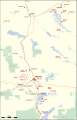
- It's good but in this form of limited help. God different idea and I'm already underway with the first map. Please do me another favor: can you please check the follwoing link: Overpass Gold Mine Map ... and compare with your list or what you want to see on the map. Tell me, which mines you do not see in my link. Pechristener (talk) 01:53, 1 May 2022 (UTC)
- Is this good enough for your purposes? Calistemon (talk) 12:18, 29 April 2022 (UTC)
- Actually, I can't see any, it just shows a standard OSM map for me. In regards to the above format, the location template here on commons is a bit unhelpful. Would the version at en:User:Calistemon/sandbox be of more use to you? Calistemon (talk) 06:54, 1 May 2022 (UTC)
- Wehn you open my link ... do you not see a green button in the top left corner. Press this green button and then you should see all the gold mines in the map. Pechristener (talk) 06:57, 1 May 2022 (UTC)
- Yes, now I do! At a glance:
- Wehn you open my link ... do you not see a green button in the top left corner. Press this green button and then you should see all the gold mines in the map. Pechristener (talk) 06:57, 1 May 2022 (UTC)
- Boddington, Wiluna, Edna May, Big Bell, Andy Well, Beta Hunt, Bluebird, BrightStar, Burnakura, Coyote, Deflector, Fortnum, Garden Well, Hill 50, Indee, Jaurdi, Golden Grove, Guyere, Kanowna Bell, Kirkalocka, Moolart Well, Marvel Loch, Mount Ida, Nicolsons, Norseman, Plutonic, Paulsons, Second Fortune, Telfer, Super Pit, Youanmi, Gidgee, are all missing
- St Ives appears three times
- Mount Morgans shows the old workings but not the new ones, which are unnamed just to the south-east
- There is an unnamed dot to the south-east of daisy-Milano which should be Randalls
- King of the Hills appears under its old name, Tarmoola
- I presume you compiled this of what is on OSM? Most of them I have marked up in the recent past and linked to Wikidata, so any mistakes there could well be mine! Calistemon (talk) 08:01, 1 May 2022 (UTC)
- Well done, this helps. I just show you the working map, which is not yet complete. But you see, in which direction it may go. Pechristener (talk) 11:07, 1 May 2022 (UTC)
- Pechristener (talk) 11:18, 1 May 2022 (UTC)
- Looks good! Calistemon (talk) 12:18, 1 May 2022 (UTC)
- OK, please check now the Kalgoorlie Leonora map. The file is updated. All the mines listed above that are in this area should now be visible. If OK, I'll do the other maps. Pechristener (talk) 08:15, 3 May 2022 (UTC)
- Looks good! Calistemon (talk) 12:18, 1 May 2022 (UTC)
- Pechristener (talk) 11:18, 1 May 2022 (UTC)
- Well done, this helps. I just show you the working map, which is not yet complete. But you see, in which direction it may go. Pechristener (talk) 11:07, 1 May 2022 (UTC)
- I presume you compiled this of what is on OSM? Most of them I have marked up in the recent past and linked to Wikidata, so any mistakes there could well be mine! Calistemon (talk) 08:01, 1 May 2022 (UTC)
-
 Gold mines Kalgoorlie Leonora
 -
 Gold mines Kalgoorlie
 -
 Gold mines Leonora
 -
 Gold mines Meekathara Leinster
.svg)


- All looks good, except that the Super Pit at Kalgoorlie is missing a label. I have already replaced the old maps with your new ones at the English and German Wikipedia. Fantastic work yet again! Calistemon (talk) 12:45, 3 May 2022 (UTC)
- Super Pit is added. Last map, I will do, too. Pechristener (talk) 18:51, 3 May 2022 (UTC)
- Now, all four maps are there. Sorry for the wrong file name of the last one. It will be corrected. Pechristener (talk) 08:55, 4 May 2022 (UTC)
- Thank you for your great work! I have changed over and added the new map to all relevant articles. Just one small thing to highlight, the Hill 50 mine at Mount Magnet is missing its label. Calistemon (talk) 16:54, 4 May 2022 (UTC)
- Label of the 50 Hill Mine is fixed. Pechristener (talk) 09:15, 7 May 2022 (UTC)
- Thank you for your great work! I have changed over and added the new map to all relevant articles. Just one small thing to highlight, the Hill 50 mine at Mount Magnet is missing its label. Calistemon (talk) 16:54, 4 May 2022 (UTC)
- Now, all four maps are there. Sorry for the wrong file name of the last one. It will be corrected. Pechristener (talk) 08:55, 4 May 2022 (UTC)
- Super Pit is added. Last map, I will do, too. Pechristener (talk) 18:51, 3 May 2022 (UTC)
File:Straßenbahn Berlin Netz September 2015.png
Hallo Pechristener,
da du der Ersteller der Karte Streckennetz der Berliner Straßenbahn bist, wollte ich dich mal fragen, ob du diese wieder aktualisieren könntest. Die BVG hat im Südosten die Strecke von der Karl-Ziegler-Straße zum S-Bhf Schöneweide verlängert und diese inzwischen auch in Betrieb genommen (siehe Streckennetz (im pdf-Format)). Viele Grüße Maschienenbau (talk) 21:54, 1 December 2022 (UTC)
- Die Anpassung ist gemacht. Die neue Karte ist hier
Straßenbahn Berlin Netz Dezember 2022.png:
Pechristener (talk) 17:46, 3 December 2022 (UTC)- Hallo Pechristener, könntest du über die Karte nochmal drüberschauen? Es gibt hier und da ein paar Fehler in der Darstellung. Z.B. sind regulär befahrene Wendeschleifen wie Falkenberg in dick dargestellt, andere wie in Ahrensfelde hingegen nicht. Zudem sind die Schleifen meist über die orange Linie bzw. die Haltestellensymbole gelegt, besser wäre dahinter. Haltestellenbezeichnung sind mal mit schwarzer, mal mit dunkelgrauer Schrift versehen, zudem fehlen bei vielen S- und U-Bahnhöfen (sofern sie als Straßenbahnhaltestelle gemeint sind) das vorstehende S bzw. U. In den Linienicons ist die Schrift nicht immer mittig platziert (gut zu sehen an der M17 Gehrenseestraße). Die M13 endet an der Haltestelle S Warschauer Straße (und befährt auch die dort gelegene Schleife), nur die M10 fährt eine Tür weiter. Zudem wollte ich dich fragen, ob du die künftige Streckenverlegung am S-Bahnhof Schöneweide sowie die Neubaustrecke zur Turmstraße mit aufnehmen könntest. Wenn du möchest (das ist jetzt nicht böswillig gemeint), könnte ich die Karte nochmal genau durchgehen und dir die einzelnen Punkte auflisten. Inhaltlich ist der Plan weitestgehend richtig. -- Platte U.N.V.E.U. 12:29, 4 December 2022 (UTC)
- work in progress Pechristener (talk) 23:59, 12 December 2022 (UTC)
- Für die künftige Streckenverlegung am S-Bahnhof Schöneweide habe ich keine Daten. Pechristener (talk) 19:46, 15 December 2022 (UTC)
- ... den Rest habe ich nachgebessert. Pechristener (talk) 20:25, 15 December 2022 (UTC)
- Danke schonmal bis hierher. Ich konnte mich dennoch nicht zurückhalten, den Plan etwas genauer unter die Lupe zu nehmen, da seit der letzten Version von 2015 doch einiges mehr passiert ist. Lass dich nicht von der Masse abschrecken, es handelt sich in den meisten Fällen um umbenannte Haltestellen.
- Die Verlegung in Schöneweide kannst du hier nachlesen, dort ist auch ein kleiner Übersichtsplan, ich hoffe der genügt.
- In einigen Fällen ist die Schrift der Linienicons leider immernoch nicht mittig platziert. Die Farben sind auch nicht mehr aktuell, die richtigen findest du hier, vielleicht wäre es einfacher, die Bilddateien direkt auf dem Plan einzubinden?
- Um etwas Platz zu sparen, könntest du anstelle des ausgeschriebenen Straße auch Str. verwenden, die Abkürzung ist gängig und bedarf keiner Erklärung. In einigen Fällen hast du es ja auch schon so umgesetzt, z.B. Marienburger Str.
- Hinsichtlich der Schriftgröße würde ich dir empfehlen, das ganze etwas einheitlicher zu gestalten, also z.B. etwas größer und ggf. fetter für (Zwischen-)Endhaltestellen, normale Schrift für alle anderen Haltestellen. Es ist z.B. nicht nachvollziehbar, warum die Haltestelle U Osloer Straße kleiner dargestellt wird als S Bornholmer Straße, obwohl zwischen beiden kaum ein Unterschied besteht.
- Könntest du Haltestellen gleichen Namens, die weiter zueinander entfernt liegen, in irgendeiner Form als verbunden darstellen? Z.B. durch einen Balken oder ähnliches.
- Linien M1/50: U Vinetastraße statt Vinetastraße
- Linien M1/M10/12: Die Icons für U Eberswalder Straße (in der Danziger Straße und Kastanienallee) könnten zu einem Punkt zusammengefasst werden.
- Linien M1/M8: Das Icon für U Rosenthaler Platz müsste auf die Kreuzung verlegt werden, da so sonst der Eindruck entsteht, dass die M8 hier nicht hält.
- Linien M1/12: Das Icon für S+U Friedrichstraße müsste etwas weiter nördlich platziert werden, knapp unterhalb des S-Bahn-Symbols.
- Linie M2: Die Bezeichnung Wendeschleife Am Steinberg kann m.E entfallen. Da hier einzelne Züge der M2 enden, könnte man die Schleife auch in orange (nicht blassorange) darstellen.
- Linie M2: Tino-Schwierzina-Straße statt Berliner Straße/Wiesenstraße
- Linie M2: S+U Alexanderplatz/Memhardstraße statt Memhardstraße
- Linien M4/M17: Prendener Straße statt Falkenberger Chaussee/Prendener Straße
- Linien M4/27: Buschallee/Hansastraße wird an der 27 nur in Richtung Hohenschönhausen bedient.
- Linien M4/12: Weißer See statt Berliner Allee/Indira-Gandhi-Straße
- Linien M5/M17: Die Gleisschleife Gehrenseestraße könnte analog zur M2 Am Steinberg auch in orange dargestellt werden.
- Linien M5/27: Alt-Hohenschönhausen statt Hauptstraße/Rhinstraße
- Linien M5/M6/M13: Hohenschönhauser Straße statt Hohenschönhauser Straße/Weißenseer Weg
- Linien M5/12: Hannoversche Straße statt U Oranienburger Tor (betrifft hier also nur die Haltestelle in der Chausseestraße)
- Linien M5/M8/M10/12: Die Haltestelle U Naturkundemuseum hat ihre Bahnsteige bzw. Schilder einmal in der Chausseestraße und einmal in der (westl.) Invalidenstraße, was dazu führt, dass die M5 beide Haltestellen anfährt, aber nur in Fahrtrichtung Hauptbahnhof auch zweimal hält. Die M8 und M10 halten dort in beiden Richtungen. Der Einfachheit halber würde ich hier aber einen zentralen Punkt auf der Kreuzung bevorzugen.
- Linien M6/M17/16/27: Die Haltestelle Landsberger Allee/Rhinstraße kann, auch wenn beide Bahnsteigpaare in der Tat nicht direkt nebeneinander liegen, mit einem Punkt auf der Kreuzung dargetellt werden.
- Linien M8/12: Die Haltestelle Brunnenstraße/Invalidenstraße muss auf der Kreuzung platziert werden, da hier auch die 12 hält.
- Linien M8/12: Die Haltestelle Pappelplatz dafür etwas nach Westen rücken (etwa unter das e vom Pappelplatz)
- Linien M13/16: Jessnerstraße statt Scharnweberstraße, zusätzlich wurde in Richtung Warschauer Straße eine neue Haltestelle Traveplatz in Betrieb genommen, sie müsste unmittelbar nördlich der Kreuzung Weichselstraße/Travestraße liegen. Bei dieser Gelegenheit könnte man auch (in rot) die Wendeschleife Müggelstraße/Travestraße mit aufnehmen.
- Linien M13/21: Holteistraße statt Boxhagener Straße/Holteistraße
- Linien M17/27/37: Alfred-Kowalke-Straße statt Am Tierpark/Alfred-Kowalke-Straße
- Linien M17/27/37: Die Haltestellen S Karlshorst und S Karlshorst/Wandlitzstraße (ist hier nicht so benannt) sind zusammengefasst worden und befinden sich jetzt unterhalb der Bahnbrücke.
- Linien M17/21/27/37: Die Haltestelle Treskowallee/Ehrlichstraße wurde in der Treskowallee aufgelassen und weiter südlich der Kreuzung durch die Haltestelle Traberweg ersetzt. Die Haltestelle in der Ehrlichstraße an der 21 bleibt und heißt weiterhin auch so.
- Linien M17/21/27/37: Volkspark Wuhlheide statt Treskowallee/Volkspark Wuhlheide
- Linie M17: Wendeschleife Adlershof in orange
- Linien 12/27: Falkenberger Straße/Berliner Allee statt Berliner Allee/Falkenberger Straße
- Linie 18: Die Linie wurde bis Landsberger Allee/Petersburger Straße verlängert, die anschließende Gleisschleife in der Virchowstraße/Langenbeckstraße müsste wegen der M6/M8 in orange dargestellt werden.
- Linie 21: Scheffelstraße statt Scheffelstraße/Paul-Junius-Straße
- Linie 21: James-Hobrecht-Straße statt Samariterstraße
- Linie 21: Heizkraftwerk Klingenberg statt Heizkraftwerk
- Linie 21: Blockdammweg statt Blockdammweg/Ehrlichstraße
- Linien 21/37/61/67: Die Gleisschleife S Schöneweide wurde im Sommer außer Betrieb gesetzt, die genannten Linien dürften derzeit mit ZR-Wagen fahren. Bei der Aufnahme der neuen Streckenführung braucht also auf die alte Schleife keine Rücksicht genommen werden.
- Linie 27: Orankestrand statt Stadion Buschallee/Suermondtstraße
- Linien 27/60/67: Weiskopfstraße statt Parkstraße
- Linien 62/63 Rahnsdorfer Straße statt Mahlsdorf/Rahnsdorfer Straße (auch wenn der Plan etwas anderes sagt, aber der OT wird hier nur erwähnt, da es sich um eine Endhaltestelle handelt)
- Linie 68: Hirtestraße statt Köpenick Hirtestraße (gleiche Begründun wie oben)
- Linie 68: Königsseestraße statt Regattastraße/Schule
- Linie 68: Die Wendeschleife am S Grünau fehlt.
- Linie 68: Bammelecke wird nicht mehr als Saisonhalt ausgewiesen.+
- Die Informationen habe ich der Netzspinne entnommen, Stand ist der 16. Dezember 2022.
- Es mag nun etwas viel zusammengekommen sein, ich bitte das zu entschuldigen. Die geänderten Farben und viele der Umbenennungen sind bereits zu früheren Fahrplanwechseln erfolgt. Leider hatte ich es bislang versäumt, die Pläne diesbezüglich korrigieren zu lassen. Letztlich führt aber kein Weg drumherum, wenn der Plan aktuell sein soll. -- Platte U.N.V.E.U. 15:26, 17 December 2022 (UTC)
- nachgebessert Pechristener (talk) 18:51, 19 December 2022 (UTC)
- Danke für die schnelle Umsetzung. Ein paar Kleinigkeiten habe ich leider noch übersehen: An der Haltestelle Nordend (M1 in Niederschönhausen) ist das Symbol hinter der orangen Linie verschwunden. Und die 50 endet tagsüber meist an der Björnsonstraße, nach Wedding gehts nur in der HVZ. S Springpfuhl müsste nach Verlängerung der 18 normal dargestellt werden. Am S+U Lichtenberg kann die Haltestelle Siegfriedstraße auch in normaler Größe dargestellt werden. Der Rest beträfe eher Feinheiten in der Darstellung und ist weniger inhaltlicher Natur. -- Platte U.N.V.E.U. 22:30, 19 December 2022 (UTC)
- nachgebessert Pechristener (talk) 18:51, 19 December 2022 (UTC)
- Danke schonmal bis hierher. Ich konnte mich dennoch nicht zurückhalten, den Plan etwas genauer unter die Lupe zu nehmen, da seit der letzten Version von 2015 doch einiges mehr passiert ist. Lass dich nicht von der Masse abschrecken, es handelt sich in den meisten Fällen um umbenannte Haltestellen.
- ... den Rest habe ich nachgebessert. Pechristener (talk) 20:25, 15 December 2022 (UTC)
- Für die künftige Streckenverlegung am S-Bahnhof Schöneweide habe ich keine Daten. Pechristener (talk) 19:46, 15 December 2022 (UTC)
- work in progress Pechristener (talk) 23:59, 12 December 2022 (UTC)
- Hallo Pechristener, könntest du über die Karte nochmal drüberschauen? Es gibt hier und da ein paar Fehler in der Darstellung. Z.B. sind regulär befahrene Wendeschleifen wie Falkenberg in dick dargestellt, andere wie in Ahrensfelde hingegen nicht. Zudem sind die Schleifen meist über die orange Linie bzw. die Haltestellensymbole gelegt, besser wäre dahinter. Haltestellenbezeichnung sind mal mit schwarzer, mal mit dunkelgrauer Schrift versehen, zudem fehlen bei vielen S- und U-Bahnhöfen (sofern sie als Straßenbahnhaltestelle gemeint sind) das vorstehende S bzw. U. In den Linienicons ist die Schrift nicht immer mittig platziert (gut zu sehen an der M17 Gehrenseestraße). Die M13 endet an der Haltestelle S Warschauer Straße (und befährt auch die dort gelegene Schleife), nur die M10 fährt eine Tür weiter. Zudem wollte ich dich fragen, ob du die künftige Streckenverlegung am S-Bahnhof Schöneweide sowie die Neubaustrecke zur Turmstraße mit aufnehmen könntest. Wenn du möchest (das ist jetzt nicht böswillig gemeint), könnte ich die Karte nochmal genau durchgehen und dir die einzelnen Punkte auflisten. Inhaltlich ist der Plan weitestgehend richtig. -- Platte U.N.V.E.U. 12:29, 4 December 2022 (UTC)

Railway map of Uzbekistan

Hi. Your map of the railways of Uzbekistan is widely used in Wikipedia. But the map is a bit outdated. If you can update this map it will be great. New railways have been built in Uzbekistan, which are not on the map. For example Bukhara - Urgench and Urgench - Khiva. Rtfroot (talk) 21:51, 3 December 2022 (UTC)
- Map updated. Pechristener (talk) 22:44, 3 December 2022 (UTC)
- thanks for your work Rtfroot (talk) 12:01, 4 December 2022 (UTC)
Transkaspische Eisenbahn
Could you please update this map with actual uzbekistan lines? A line has been built in Uzbekistan since 2015. Thanks. Rtfroot (talk) 20:23, 12 February 2023 (UTC)
- Please tell me, which line is missing. Pechristener (talk) 20:20, 15 February 2023 (UTC)
- Buchara - Urganch Rtfroot (talk) 10:39, 24 February 2023 (UTC)
Update request for the Edinburgh Tram maps
Hello.
Can you update the maps
- File:Edinburgh Trams Map.png => done
- File:Edinburgh trams.svg => Edinburgh trams 2023.svg
- File:Edinburgh trams map.png => Edinburgh trams map 2023.png
- File:Edinburgh tramway map.svg => done by Cnbrb
- File:Edinburgh trams and suburban railway.svg => Edinburgh trams and suburban railway 2023.svg
- File:Tram map of Edinburgh.svg => Tram map of Edinburgh 2023.svg
- File:Edinburgh Trams interchange map.png => Edinburgh Trams interchange map 2023.svg
- File:Edinburgh Trams track diagram.PNG?
Today, on 7 June 2023, the second phase with 8 new stations of the Edinburgh Tram was opened, which extended the tram network to 14 km and a total of 23 stations.
Yours sincerely, Multituberculata (talk) 16:00, 7 June 2023 (UTC)
- Looks like quite a bit of work, but I'll take care of it. Pechristener (talk) 02:41, 8 June 2023 (UTC)
- Thanks for your work on this, and thanks for adding it to Wikivoyage:Edinburgh. Note that the York Place stop has closed, as the new Picardy Place stop is across the road from it. Also the map is missing Balfour Street (which is is in about the place the map shows Picardy PLace). AlasdairW (talk) 22:52, 12 June 2023 (UTC)
- is now fixed on both maps Pechristener (talk) 15:10, 19 June 2023 (UTC)
- Many thanks. That is very useful. I look forward to exploring the full route on one of these warm evenings. AlasdairW (talk) 20:24, 20 June 2023 (UTC)
- is now fixed on both maps Pechristener (talk) 15:10, 19 June 2023 (UTC)
- Thank you very much for the updates of the first two maps and for creating an additional map. When you have time and if it is technically possible, can you update the other maps as well? Multituberculata (talk) 11:07, 17 June 2023 (UTC)
- ... es fehlt jetzt noch eine. Pechristener (talk) 02:05, 23 August 2023 (UTC)
- Thanks for your work on this, and thanks for adding it to Wikivoyage:Edinburgh. Note that the York Place stop has closed, as the new Picardy Place stop is across the road from it. Also the map is missing Balfour Street (which is is in about the place the map shows Picardy PLace). AlasdairW (talk) 22:52, 12 June 2023 (UTC)
Update request
Hello,
Can you update the maps File:Île-de-France - plan des tramways.png and File:Île-de-France - plan des tramways et des bus en site propre.png, by coloring the tram line T10 in red? This Parisian tram line was opened to service on 24 June 2023.
Source: https://www.urban-transport-magazine.com/en/t10-another-new-tram-line-in-paris/
That is it from me for this year.
Yours sincerely, Multituberculata (talk) 19:41, 1 July 2023 (UTC)
- Beide Karten gemacht Pechristener (talk) 02:04, 23 August 2023 (UTC)
Notification about possible deletion

|
Some contents have been listed at Commons:Deletion requests so that the community can discuss whether they should be kept or not. We would appreciate it if you could go to voice your opinion about this at their entry.
If you created these pages, please note that the fact that they have been proposed for deletion does not necessarily mean that we do not value your kind contribution. It simply means that one person believes that there is some specific problem with them, such as a copyright issue. Please see Commons:But it's my own work! for a guide on how to address these issues. |
Affected:
And also:
- File:Aare, Thun, Kraftwerk AAREwerk62 und AAREwerk94.jpg
- File:AB Gem 2 2 1096.jpg
- File:Albistunnel.jpeg
- File:Bahnhof Dielsdorf 1990.png
- File:Bahnhof Steinmaur 2008.JPG
- File:Batiment pic-pci.png
- File:BDB C11.jpg
- File:BDB Mutschälle-Zähni .jpg
- File:BDB X350.jpg
- File:Diga di Carmena.jpg
- File:Kavernenzentrale Amsteg II im Bau.jpg
- File:Kleinkraftwerk Leitschach.jpg
- File:Kraftwerk Arniberg - Maschinensaal Zentrale Amsteg.jpg
- File:Martigny bourg power station alpiq.jpg
- File:MOB Gem2-2 2502.jpg
- File:MVR HGem2-2 2501.jpg
- File:SBB Be 4 6 1631 (Postcard).jpg
- File:TPF-Gem-22 18.jpg
- File:Turbine AAREwerk62, Thun.jpg
.jpg&action=edit&redlink=1)
Yours sincerely, Gestumblindi (talk) 15:25, 24 October 2023 (UTC)
- kann alles weg Pechristener (talk) 22:26, 24 October 2023 (UTC)