Ardennes
low mountain range in Belgium, France, Luxembourg and Germany   | |||||
| Upload media | |||||
| Instance of |
| ||||
|---|---|---|---|---|---|
| Named after | |||||
| Location |
| ||||
| Width |
| ||||
| Length |
| ||||
| Mountain range | |||||
| Highest point | |||||
| Area |
| ||||
| Different from | |||||
| Said to be the same as | Ardenne | ||||
 | |||||
-
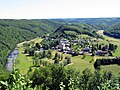 Landscape of Frahan inside the bend of the Semois
 -
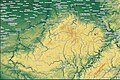 Morphologically connected mountains of Ardennes and Eifel, framed by the rivers Semois, Meuse, Moselle and Rhine. The highest elevation is Mt. Hohe Acht at 746.9 m above sea level
 -
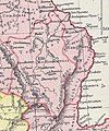 Arduenna silva between River Maas and River Rhine
 -
 Belgium
 -
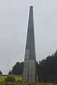 War memorial for the 1st Infantry Division (Big Red One) in Belgium
 -
 Rock Bayard of Dinant, on the right bank of the Meuse. According to a legend, a magic horse jumped from the top of this rock to the left bank of the river, carrying the Quatre Fils Aymon fleeing Charlemagne


History
edit-
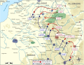 Battle of the Ardennes (1914) was the second of the Battles of the Frontiers
 -
 Battles of the Frontiers (1914) involved a series of collisions between the French and the German armies. The French forces carried out a counteroffensive ("Plan XVII"), attacking the flank of the westwards-advancing German Army executing its Schlieffen Plan
 -
 Panorama of Botassart or Le Tombeau du Géant (Giant's Tomb) along River Semois
 -
 View of the Meuse in the French part


.jpg)
