Beamish Museum: Pit Village
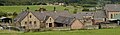
The Pit Village in Beamish Museum is in the south of the site, inside the tram oval, to the west of the Colliery, and east of Home Farm (outside the oval). A single road runs through it (Pitfield Street), from west to east - the east end being the entrance to the colliery site. The village is bordered to the north by rail sidings extending west out of the colliery site's railway system.
General views
edit-
 From the west
 -
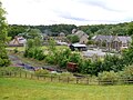
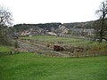
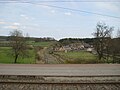
 From the north west, across the colliery tracks
 -
 From the north west, across the colliery tracks
 -
 From the north west, across the colliery tracks
 -
 From the north west, across the colliery tracks
 -
 From the north west, across the colliery tracks
 -
 From the north west, across the colliery tracks
 -
 From the north west, across the colliery tracks
 -
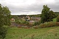
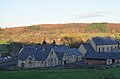
 From the south west
 -
 From the south west
 -
 From the south west
 -
 From the south west
 -
 From the south west
 -
 From the south west
 -
 From the south west
 -
 From the south west


.jpg)
.jpg)
.jpg)
.jpg)
.jpg)
.jpg)
.jpg)
.jpg)
.jpg)


Partial views
edit-
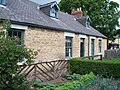
 School & chapel, from the south west
 -
 Miners cottages, from the north west
 -
 Miners cottages, from the north west
 -
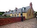
 Miners cottages, from the west
 -
 Miners cottages, from the west
 -
 Miners cottages & chapel, from the west
 -
 Chapel & school, from the west
.jpg)
.jpg)
.jpg)
.jpg)

.jpg)
.jpg)
Pitfield Street
editStreet views
edit-
 From the west
 -

-
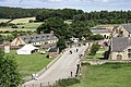
 Looking east
 -
 Looking east
 -
 Looking east
 -
 Looking east
 -
 Looking east
 -
 Looking east
 -
 Looking west
 -
 Looking west


.jpg)

,_30_March_2013.jpg)
,_6_October_2012.jpg)

,_1_October_2008_uncropped.jpg)

.jpg)
Detail
edit-
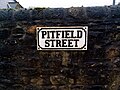 street sign (outside the school)
 -
 Fencing outside the school

,_Pit_Village,_Beamish_Museum,_1_September_2011.jpg)
Fields opposite the school
editOpposite the school on the north side of Pitfield Street are some three fields, delimited by N-S wooden fences, and bounded by the colliery sidings to the north, the rest of Pitfield Street to the west, and the miners cottages to the east.
General views
edit-
 Looking east across the fields

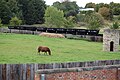
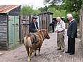
Pony field
editThe field closest to the cottages is used to graze the museum's pit ponies.
-
 Looking north
 -
 Looking north
 -
 Looking north
 -
 Looking north west
 -
 Looking north west

.jpg)
.jpg)
.jpg)
.jpg)
Tower
editIn the pony field stands this small tower.
| Object location | | View all coordinates using: OpenStreetMap |
|---|
-
 south side

Small stable
editIn the SW corner of the pony field is this small stable.
| Object location | | View all coordinates using: OpenStreetMap |
|---|
-
 Pitfield Street side
 -
 Pitfield Street side
 -
 From the NW


Quoits field
edit| Object location | | View all coordinates using: OpenStreetMap |
|---|
On the middle field there are some pitches for the game of Quoits.
-
 Looking north
 -
 Championship event


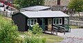
Hut
editIn the SE corner of the Quoits field, stands this green hut.
-
 From the south
 -
 From the north west
.jpg)
.jpg)
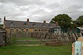
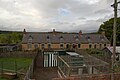
Cottages
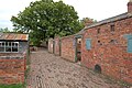
editOn the north side of Pitfield street is a row of miner's cottages. They are set back from the road with long front gardens. Francis Street is a lane that runs up both sides and along the back, forming a back alley, to the north of which are some out buildings.
| Object location | | View all coordinates using: OpenStreetMap |
|---|
Front elevation & gardens
edit-
-
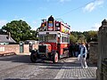
 (from a bus)
 -

-
-

-
-

.jpg)
.jpg)


.jpg)
Rear elevation, back yards, Francis Street back alley & outbuildings
edit-
 back yard
 -
 back yards (east end)
 -
 back alley (looking east)
 -
 back alley (looking west)
 -
 outbuildings (west side)
 -
 outbuildings (west side)
 -
 outbuildings (west side)
 -
 outbuildings (west end)
 -
 outbuildings (east end)
 -
 outbuildings (south side)

.jpg)
.jpg)
.jpg)
.jpg)
.jpg)
.jpg)

.jpg)

Detail
edit

Interiors
edit-
 Kitchen of No. 2

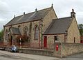
Chapel
editThe "Pithill Methodist Chapel" is on the south side of Pitfield street, east of the school and opposite the miner's cottages.
| Object location | | View all coordinates using: OpenStreetMap |
|---|
-
 Pitfield street facade
 -
 Pitfield street facade
 -
 Pitfield street facade
 -
 Pitfield street facade
 -
 west end/Pitfield street facade
 -
 Rear elevation


.jpg)
_(cropped).jpg)
_(cropped).jpg)

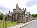
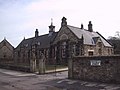
School
edit- Inscription: 1891 Beamish School Board
The school is on the south side of Pitfield Street, set back from it with a small lawn. To the rear is the playground. To the east is the chapel, while across the road is the small stable.
| Object location | | View all coordinates using: OpenStreetMap |
|---|
Exterior
edit-
 Pitfield Street facade
 -
 Pitfield Street facade
 -
 Pitfield Street facade
 -
 Pitfield Street facade
 -
 Pitfield Street facade
 -
 Pitfield Street facade
 -
 Pitfield Street facade
 -
 west end/Pitfield Street facade
 -
 east end/Pitfield Street facade
 -
 Pitfield Street facade (boy's entrance)
 -
 Rear elevation & playground
 -
 Rear elevation & playground
 -
 Extent of the rear boundary wall around the playground
 -
 Playground, looking east


.jpg)


.jpg)
.jpg)


Interior
edit-

-

-

-

-

-

-

-

-
 Queen Victoria
 -
 Education Act notice
 -
 Map
Map -
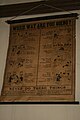
 History poster
 -
 Health poster
 -
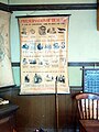 Health poster
 -
 Health poster
 -
 Health notice
 -
 Anatomy poster
 -
 Anatomy poster
 -
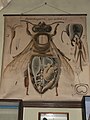 Anatomy poster


.jpg)
.jpg)
.jpg)
.jpg)
.jpg)
.jpg)

.jpg)
.jpg)
.jpg)

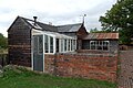
Davy's fish restaurant
editBuilt on the field to the south of the chapel is 'Davy's Fried Fish', a fish and chip restaurant. There are two buildings - the main building where the fish is fried (which is parallel to the chapel and has the business name painted on the roof), plus the wood built Eating Saloon, perpedicular to it and to the west, providing seating for diners. A picnic area is to the south, with another small outbuilding on its south edge.
-
 The entire complex from the south, showing the proximity to the chapel, plus the picnic area and outbuilding (bottom right)
 -
 The entire complex from the south, showing the proximity to the chapel, plus the picnic area and outbuilding (bottom right)
 -
 The south elevation of the main building
 -
 The south elevation of the main building
 -
 The gable end of the main building
 -
 Looking east across the picnic area
 -
 The Eating Saloon building, from the south

.jpg)
.jpg)
.jpg)
.jpg)


.jpg)
.jpg)