Callerton Parkway Metro station
metro station in Tyne & Wear
English: Callerton Parkway 55°01′40″N 1°42′13″W / 55.0279°N 1.7036°W is a station on the Green Line of the Tyne and Wear Metro. It is a parkway station located just off the off the A696 road, in the rural area in between the north west edge of urban Newcastle and the city's airport (which is itself served by the next stop on the line).
| Opened | New or converted |
Number of platforms | Track alignment | Tyne & Wear metropolitan borough |
| 17 November 1991 | New | 2 | NNW-SSE | Newcastle upon Tyne |
| Layout | ||||
| Two side platforms at ground level, with platform level station buildings at their northern ends | ||||
| Platform no. and position |
Direction of travel M |
Previous stop |
Route | Next stop |
| Platform 1 East |
Southbound | Airport | Green Line to South Hylton (stop 02 of 31) | Bank Foot |
| Platform 2 West |
Northbound | Bank Foot | Green Line to Airport (stop 30 of 31) | Airport |
| Notes | ||||
| * M - these are compass headings, which in this station's case do not correspond to the directions diagrammatically indicated on the official Metro route map archive copy at the Wayback Machine - Northbound is Westbound & Southbound is Eastbound on the Metro map | ||||
| Station buildings | ||||
| Two simple rectangular structures in the original style, both 30' by 15' | ||||
| Access | ||||
| Footpaths 75' north to a level crossing with the E-W running B6918, and another east to the access road for the parkway car park | ||||
| Protection from the elements | ||||
| Station building only | ||||
| Interchanges | ||||
| car - parkway car park directly to the east of the station (another directly to the west is a private airport parking facility) | ||||
-
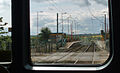 The view south across the B6918 level crossing back to the station, from the rear of a train which has just departed from Platform 2
9 May 2007
