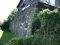
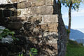
Category:"Vor dem Wald" tower
| Object location | | View all coordinates using: OpenStreetMap |
|---|
 | |||||
| Upload media | |||||
| Instance of | |||||
|---|---|---|---|---|---|
| Location |
| ||||
| Heritage designation | |||||
 | |||||
Media in category ""Vor dem Wald" tower"
The following 5 files are in this category, out of 5 total.
-
 Filzbach Römerturm.JPG 1,600 × 1,200; 669 KB
-
 Filzbach Römerturm02.JPG 1,356 × 984; 476 KB
-
 Filzbach Römerturm03.JPG 1,588 × 1,092; 582 KB
-
 Filzbach Römerturm04.JPG 1,600 × 1,200; 596 KB
-
 Filzbach-Wachtturm.jpg 1,200 × 800; 1.03 MB


