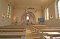
Category:Église Saint-Hubert (Pontpierre)
| Object location | | View all coordinates using: OpenStreetMap |
|---|
  | |||||
| Upload media | |||||
| Instance of | |||||
|---|---|---|---|---|---|
| Location |
| ||||
 | |||||
Media in category "Église Saint-Hubert (Pontpierre)"
The following 2 files are in this category, out of 2 total.
-
 KIE STE 032.jpg 3,270 × 2,151; 2.1 MB
-
 Steebrécken7.jpg 2,045 × 2,925; 969 KB