Category:Église Saint-Remy de Dampremy (1979)
| Object location | | View all coordinates using: OpenStreetMap |
|---|
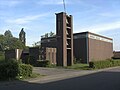
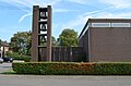
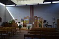
church in Dampremy, Belgium  | |||||
| Upload media | |||||
| Instance of | |||||
|---|---|---|---|---|---|
| Dedicated to | |||||
| Location | Dampremy, Charleroi, Arrondissement of Charleroi, Hainaut, Walloon Region, Belgium | ||||
| Diocese | |||||
 | |||||
Media in category "Église Saint-Remy de Dampremy (1979)"
The following 6 files are in this category, out of 6 total.
-
 Dampremy - Eglise Saint-Remy.jpg 3,072 × 2,304; 1.09 MB
-
 Dampremy - église Saint-Remy - 2014 - 2.jpg 4,928 × 3,264; 10.52 MB
-
 Dampremy - église Saint-Remy - 2014 - 3.jpg 4,768 × 3,158; 9.09 MB
-
 Dampremy - église Saint-Remy - 2014 - 4.jpg 4,928 × 3,264; 8.62 MB
-
 Dampremy - église Saint-Remy - 2014 - 5.jpg 4,928 × 3,264; 6.57 MB
-
 Dampremy - église Saint-Remy - intérieur - 01.jpg 4,791 × 3,174; 11.46 MB


