Category:Église de la Sainte-Trinité (Sandweiler)
| Object location | | View all coordinates using: OpenStreetMap |
|---|
church in Luxembourg   | |||||
| Upload media | |||||
| Instance of | |||||
|---|---|---|---|---|---|
| Location | Sandweiler, Canton of Luxembourg, Luxembourg | ||||
 | |||||
Subcategories
This category has only the following subcategory.
I
Media in category "Église de la Sainte-Trinité (Sandweiler)"
The following 20 files are in this category, out of 20 total.
-
 Dier Kierch Sandweiler.jpg 2,797 × 4,210; 7 MB
-
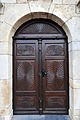
 EntrKi2.JPG 702 × 1,081; 53 KB
-
 Hunn um Kierchtuerm Sandweiler.jpg 2,880 × 2,160; 2.78 MB
-
 Kierch Sandweiler-001.jpg 2,212 × 3,330; 4.04 MB
-
 Kierch Sandweiler-002.jpg 3,722 × 2,696; 5.35 MB
-
 Kierch Sandweiler-003.jpg 3,662 × 2,536; 5.59 MB
-
 Kierch Sandweiler-004.jpg 3,842 × 2,552; 5.83 MB
-
 Kierch Sandweiler-005.jpg 2,579 × 3,883; 4.37 MB
-
 Kierch Sandweiler-006.jpg 2,780 × 4,187; 5.38 MB
-
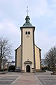
 Kierch Sandweiler.jpg 3,969 × 2,636; 5.74 MB
-
 Kiercheportal Sandweiler.jpg 3,921 × 2,604; 5.78 MB
-
 Kierchtuerm Sandweiler-001.jpg 2,350 × 3,133; 3.51 MB
-
 Kierchtuerm Sandweiler.jpg 2,273 × 3,031; 3.28 MB
-
 KierR1.JPG 1,411 × 2,572; 342 KB
-
 Plack Kierch Sandweiler.jpg 3,806 × 2,528; 6.17 MB
-
 Sandw Kierch V.jpg 2,052 × 3,073; 350 KB
-
 Sandweiler Kierch.jpg 4,065 × 2,700; 6.42 MB
-
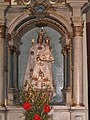 SWConsolatrixwaiss.jpg 1,536 × 2,048; 1.11 MB
-
 SWDalmatik.JPG 1,920 × 2,560; 2.43 MB
-
 Vue op Sandweiler, Mäerz 2017-102.jpg 6,143 × 4,100; 13.48 MB


