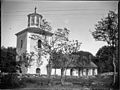
Category:Östhammars kyrka
| Object location | | View all coordinates using: OpenStreetMap |
|---|
church building in Östhammar Municipality, Sweden  | |||||
| Upload media | |||||
| Instance of | |||||
|---|---|---|---|---|---|
| Location | Östhammar, Östhammar Municipality, Uppsala County, Sweden | ||||
| Diocese | |||||
| Connects with |
| ||||
| Occupant | |||||
| official website | |||||
 | |||||
Svenska: Östhammars kyrka tillhör Frösåkers församling, Roslagens norra pastorat, Upplands norra kontrakt, Uppsala stift / Diocese of Uppsala.
|
This is a category about an ecclesiastical monument in Sweden, number 21300000003543 (sub-number: 21400000444562) in the RAÄ buildings database.
|
Subcategories
This category has the following 2 subcategories, out of 2 total.
I
P
- Pulpit in Östhammars kyrka (9 F)
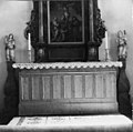
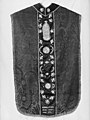
Media in category "Östhammars kyrka"
The following 66 files are in this category, out of 66 total.
-
 FörsamlingshusFrösåker.jpg 5,184 × 3,456; 7.14 MB
-
 Östhammars kyrka - KMB - 16000200143934.jpg 814 × 600; 97 KB
-
 Östhammars kyrka - KMB - 16000200143935.jpg 398 × 600; 40 KB
-
 Östhammars kyrka - KMB - 16000200143936.jpg 920 × 600; 108 KB
-
 Östhammars kyrka - KMB - 16000200143938.jpg 841 × 600; 143 KB
-
 Östhammars kyrka - KMB - 16000200143939.jpg 825 × 600; 126 KB
-
 Östhammars kyrka - KMB - 16000200143940.jpg 796 × 600; 86 KB
-
 Östhammars kyrka - KMB - 16000200143941.jpg 962 × 600; 125 KB
-
 Östhammars kyrka - KMB - 16000200143951.jpg 606 × 600; 58 KB
-
 Östhammars kyrka - KMB - 16000200143952.jpg 595 × 600; 48 KB
-
 Östhammars kyrka - KMB - 16000200143953.jpg 607 × 600; 77 KB
-
 Östhammars kyrka - KMB - 16000200143954.jpg 590 × 600; 60 KB
-
 Östhammars kyrka - KMB - 16000200143960.jpg 807 × 600; 90 KB
-
 Östhammars kyrka - KMB - 16000200143961.jpg 424 × 600; 48 KB
-
 Östhammars kyrka - KMB - 16000200143962.jpg 853 × 600; 38 KB
-
 Östhammars kyrka - KMB - 16000200143963.jpg 763 × 600; 88 KB
-
 Östhammars kyrka - KMB - 16000200143964.jpg 450 × 600; 48 KB
-
 Östhammars kyrka - KMB - 16000200143965.jpg 450 × 600; 53 KB
-
 Östhammars kyrka - KMB - 16000200143967.jpg 601 × 600; 49 KB
-
 Östhammars kyrka - KMB - 16000200143969.jpg 459 × 600; 39 KB
-
 Östhammars kyrka - KMB - 16000200143970.jpg 460 × 600; 31 KB
-
 Östhammars kyrka - KMB - 16000200143971.jpg 444 × 600; 32 KB
-
 Östhammars kyrka - KMB - 16000200143973.jpg 488 × 600; 45 KB
-
 Östhammars kyrka - KMB - 16000200143974.jpg 797 × 600; 142 KB
-
 Östhammars kyrka - KMB - 16000200143975.jpg 450 × 600; 52 KB
-
 Östhammars kyrka - KMB - 16000200143976.jpg 451 × 600; 51 KB
-
 Östhammars kyrka - KMB - 16000200143978.jpg 865 × 600; 94 KB
-
 Östhammars kyrka - KMB - 16000200143979.jpg 446 × 600; 54 KB
-
 Östhammars kyrka - KMB - 16000200143980.jpg 436 × 600; 63 KB
-
 Östhammars kyrka - KMB - 16000200143981.jpg 834 × 600; 189 KB
-
 Östhammars kyrka - KMB - 16000200143983.jpg 842 × 600; 92 KB
-
 Östhammars kyrka - KMB - 16000200143984.jpg 461 × 600; 47 KB
-
 Östhammars kyrka - KMB - 16000200143985.jpg 421 × 600; 59 KB
-
 Östhammars kyrka - KMB - 16000200143986.jpg 427 × 600; 52 KB
-
 Östhammars kyrka - KMB - 16000200143987.jpg 424 × 600; 53 KB
-
 Östhammars kyrka - KMB - 16000200143989.jpg 428 × 600; 51 KB
-
 Östhammars kyrka - KMB - 16000200143990.jpg 850 × 600; 188 KB
-
 Östhammars kyrka - KMB - 16000200143991.jpg 430 × 600; 103 KB
-
 Östhammars kyrka - KMB - 16000200143992.jpg 430 × 600; 95 KB
-
 Östhammars kyrka - KMB - 16000200143993.jpg 847 × 600; 175 KB
-
 Östhammars kyrka - KMB - 16000200143994.jpg 823 × 600; 122 KB
-
 Östhammars kyrka - KMB - 16000200143995.jpg 429 × 600; 95 KB
-
 Östhammars kyrka - KMB - 16000200143996.jpg 858 × 600; 223 KB
-
 Östhammars kyrka - KMB - 16000200143997.jpg 852 × 600; 196 KB
-
 Östhammars kyrka - KMB - 16000200143998.jpg 861 × 600; 207 KB
-
 Östhammars kyrka - KMB - 16000200143999.jpg 853 × 600; 188 KB
-
 Östhammars kyrka - KMB - 16000200144001.jpg 431 × 600; 66 KB
-
 Östhammars kyrka - KMB - 16000200144002.jpg 432 × 600; 79 KB
-
 Östhammars kyrka - KMB - 16000200144003.jpg 425 × 600; 102 KB
-
 Östhammars kyrka - KMB - 16000200144004.jpg 859 × 600; 188 KB
-
 Östhammars kyrka - KMB - 16000200144005.jpg 425 × 600; 37 KB
-
 Östhammars kyrka - KMB - 16000200144006.jpg 850 × 600; 81 KB
-
 Östhammars kyrka - KMB - 16000200144007.jpg 856 × 600; 47 KB
-
 Östhammars kyrka - KMB - 16000200144008.jpg 426 × 600; 38 KB
-
 Östhammars kyrka - KMB - 16000200144009.jpg 422 × 600; 35 KB
-
 Östhammars kyrka - KMB - 16000200144010.jpg 912 × 600; 61 KB
-
 Östhammars kyrka 1915.jpg 802 × 600; 111 KB
-
 ÖsthammarsKyrka1801.jpg 3,456 × 3,173; 3.52 MB
-
 ÖsthammarsKyrka1802.jpg 3,456 × 3,254; 3.84 MB
-
 ÖsthammarsKyrka1803.jpg 3,456 × 4,131; 5.38 MB
-
 ÖsthammarsKyrka2001.jpg 5,184 × 3,456; 6.67 MB
-
 ÖsthammarsKyrka2002.jpg 3,456 × 5,184; 8.52 MB
-
 ÖsthammarsKyrka2003.jpg 5,184 × 3,456; 6.34 MB
-
 ÖsthammarsKyrka2004.jpg 5,184 × 3,456; 7.59 MB
-
 ÖsthammarsKyrka2005.jpg 3,456 × 5,184; 8.94 MB
-
 ÖsthammarsKyrka2006.jpg 5,184 × 3,456; 8.44 MB


