Category:12-14 Long Acre, London
City of Westminster, Greater London, WC2E .jpg) | |||||
| Upload media | |||||
| Instance of | |||||
|---|---|---|---|---|---|
| Made from material | |||||
| Location | City of Westminster, Greater London, London, England | ||||
| Occupant |
| ||||
| Heritage designation |
| ||||
| Inception |
| ||||
 | |||||
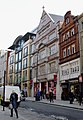
English: The former Stanford's shop at 12 and 14 Long Acre and 27a Floral Street, Covent Garden. Built 1900-01 to designs by Herbert Read and Macdonald.
Media in category "12-14 Long Acre, London"
The following 7 files are in this category, out of 7 total.
-
 12-14 Long Acre - geograph.org.uk - 5367329.jpg 379 × 640; 147 KB
-
 12-14 Long Acre - Stanfords Bookshop (geograph 2682247).jpg 3,000 × 4,000; 2.34 MB
-
 12-14 Long Acre London.jpg 5,152 × 7,082; 6.17 MB
-
 Empty Stanfords building, Long Acre - geograph.org.uk - 6211729.jpg 3,456 × 4,608; 5.44 MB
-
 Long Acre, Covent Garden - and Stanford's - geograph.org.uk - 2212832.jpg 711 × 1,024; 182 KB
-
 Stanfords, Long Acre - geograph.org.uk - 224549.jpg 480 × 640; 98 KB
-
 Stanfords.jpg 720 × 961; 194 KB


