Category:1540s maps of the Netherlands
Countries of Europe: Austria · Bulgaria · Czech Republic · Estonia · France‡ · Germany · Greece · Hungary · Italy · Lithuania · Moldova · Netherlands‡ · Poland · Portugal‡ · Romania · Russia‡ · Serbia · Spain‡ · Turkey‡ · Ukraine
‡: partly located in Europe
‡: partly located in Europe
Media in category "1540s maps of the Netherlands"
The following 6 files are in this category, out of 6 total.
-
 Cosmographia - Beschreibung aller Lender durch Sebastianum Munsterum (1545) 14.jpg 11,007 × 7,031; 7.21 MB
-
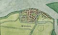 Detailed map Woudrichem 1545 (Van Deventer).jpg 1,519 × 927; 584 KB
-
 Germania Teütschland - Geldern, Brabandt, Flandren.jpg 533 × 774; 91 KB
-
 Herzogtümer Jülich-Kleve-Van Den Bergh(en) 1540.png 220 × 237; 98 KB
-
 Kaart oostelijk deel eiland Putten 1542.jpg 10,024 × 6,814; 13.95 MB
-
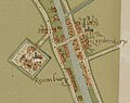 RoomburgLeiderdorp(Leiden) JacobVanDeventer 1545.jpg 621 × 491; 287 KB
_14.jpg)
.jpg)

_1540.png)

_JacobVanDeventer_1545.jpg)