Category:1550s maps of Eastern Europe
Media in category "1550s maps of Eastern Europe"
The following 11 files are in this category, out of 11 total.
-
 1550 Map of Poland - Book Museum - National Library - Minsk - Belarus (27448006382).jpg 3,648 × 2,736; 3.32 MB
-
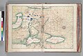 Map of Russia. HM 10. Battista Agnese, PORTOLAN ATLAS (Italy ca. 1550).jpg 6,686 × 4,543; 8.41 MB
-
 1552 S Munster Polonia et Vngaria XX raremaps.jpg 1,563 × 1,200; 2.38 MB
-
 1552 Transsylvania XXI Nova Tabula.jpg 2,048 × 1,593; 1.23 MB
-
 Fotothek df tg 0005105 Geographie ^ Karte.jpg 800 × 661; 289 KB
-
 Fotothek df tg 0005106 Geographie ^ Karte.jpg 800 × 666; 294 KB
-
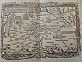
 Geographiae Claudii Ptolemaei Alexandrini (Münster, 1552) 49.jpg 10,493 × 6,692; 7.01 MB
-
 Polonia Et Ungaria XX Nova Tabula.jpg 3,186 × 2,424; 1.56 MB
-
 Poloniae et Ungariae zMünstera.jpg 2,328 × 1,840; 1.49 MB
-
 Herberstein's other map of Muscovy, 16th c.jpg 3,514 × 2,630; 2.7 MB
-
 Transylvania1559.jpg 892 × 1,276; 701 KB
.jpg)
.jpg)


_49.jpg)


