Category:1578 maps of Europe
English: 1578 maps of Europe
Español: Mapas de Europa en 1578
Suomi: Euroopan kartat vuodelta 1578
Română: Hărți ale Europei din 1578
Subcategories
This category has the following 4 subcategories, out of 4 total.
Media in category "1578 maps of Europe"
The following 9 files are in this category, out of 9 total.
-
 Ralph Agas map of Oxford 1578 Jesus marked.jpg 742 × 523; 271 KB
-
 Ralph Agas map of Oxford 1578.gif 742 × 523; 156 KB
-
 Sketch of Brasenose, 1578.png 890 × 1,084; 981 KB
-
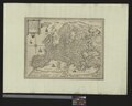 UBBasel Map 1578 Kartenslg AA 11 Europa.tiff 12,251 × 9,841; 344.93 MB
-
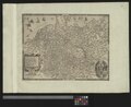 UBBasel Map 1578 Kartenslg AA 25 Germania.tiff 12,044 × 9,778, 2 pages; 336.96 MB
-
 UBBasel Map 1578 Kartenslg AA 57 Tractus Danubii prima.tiff 11,953 × 9,800, 2 pages; 666.34 MB
-
 UBBasel Map 1578 Kartenslg AA 62 Germania.tiff 11,852 × 9,726, 2 pages; 329.82 MB
-
 UBBasel Map 1578 Kartenslg Schw Cu 4 Valesia.tiff 4,542 × 5,181, 2 pages; 67.35 MB
-
 UBBasel Map Schweiz 1578 VB A2-1-4.tif 11,983 × 8,709, 2 pages; 591.38 MB


