Category:1590s maps of the Balkans
English: This category is intended to collect maps from the 1590s that show multiple Balkan countries in one map frame.
Subcategories
This category has the following 5 subcategories, out of 5 total.
Media in category "1590s maps of the Balkans"
The following 9 files are in this category, out of 9 total.
-
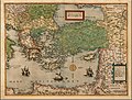
 1590 map of Thrace by Abraham Ortelius.jpg 13,292 × 10,391; 26.57 MB
-
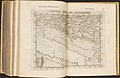
 1593 map of the Danube by Cornelis de Jode.jpg 2,326 × 1,600; 1.2 MB
-
-
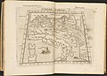
 1593 map of the Eastern Balkan Peninsula.jpg 4,078 × 2,904; 2.63 MB
-
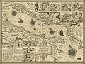
 1593 map of the Northern Balkan by Cornelis de Jode.jpg 4,230 × 2,704; 2.64 MB
-
 Tabula Europae Quinta.jpg 1,068 × 865; 121 KB
-
-
-


_07.jpg)
_38.jpg)