Category:1600s maps of Africa
Temperate regions: North America · South America · Africa · Europe · Asia · Oceania – Polar regions: – Other regions:
Subcategories
This category has the following 14 subcategories, out of 14 total.
- 1600 maps of Africa (19 F)
- 1601 maps of Africa (1 F)
- 1603 maps of Africa (5 F)
- 1606 maps of Africa (1 F)
- 1607 maps of Africa (1 F)
- 1608 maps of Africa (2 F)
- 1609 maps of Africa (2 F)
A
E
- 1600s maps of Ethiopia (1 F)
L
M
T
Media in category "1600s maps of Africa"
The following 9 files are in this category, out of 9 total.
-

-
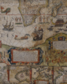
 1600s map of Africa.jpg 3,024 × 4,032; 2.59 MB
-
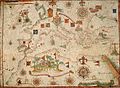
 Teiceira — South Africa 1604.png 556 × 703; 822 KB
-
-

-
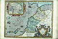 Bodleian Libraries, Fessae, et Marocchi Regna Africae celeberr.jpg 1,000 × 675; 188 KB
-
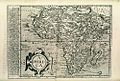 Bodleian Libraries, Map of Africa as Matthias Quaden's Aphrica.jpg 1,000 × 675; 240 KB
-
 Map of Prester John (Ethiopia) by Abraham Ortelius.jpeg 6,095 × 4,674; 6.5 MB
-
 Old Portuguese map of SA 529.JPG 3,456 × 2,304; 2.12 MB
.jpg)


_by_Abraham_Ortelius.jpeg)
