Category:1670 maps of Africa
Temperate regions: North America · South America · Africa · Europe · Asia · – Polar regions: – Other regions:
| ← 1670 1671 1672 1674 1675 1676 1677 1678 1679 → |
Media in category "1670 maps of Africa"
The following 9 files are in this category, out of 9 total.
-
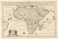
 Africae Accurata Tabula ex Officina Iacobum Meursium map.jpg 760 × 607; 145 KB
-
 Resized-inu-afrmap-3826231-recto-master.png 3,606 × 3,007; 19.99 MB
-

-
 Aethiopia Interior vel exterior - DPLA - a806aaa851d94df0ee72be3a915b385c.jpg 1,000 × 776; 235 KB
-
 Africae Accurata tabula - DPLA - 1dce0bfd6c3e0e18cf84e3399386e9b2.jpg 1,000 × 806; 281 KB
-
 Africae accurata tabula ex officina Jacobum Meursium RMG F0250.tiff 7,221 × 5,762; 119.04 MB
-
 Regna Congo et Angola RMG F0385.tiff 7,256 × 5,626; 116.79 MB
-

-


_-_Geographicus_-_Guinea-ogilby-1670.jpg)


