Category:1670s maps of South America
Temperate regions: North America · South America · Africa · Europe · Asia · Oceania – Polar regions: – Other regions:
Subcategories
This category has the following 6 subcategories, out of 6 total.
- 1670 maps of South America (1 F)
- 1671 maps of South America (3 F)
- 1672 maps of South America (7 F)
- 1674 maps of South America (1 F)
- 1675 maps of South America (1 F)
B
- 1670s maps of Brazil (12 F)
Media in category "1670s maps of South America"
The following 8 files are in this category, out of 8 total.
-

-

-
 Guiana sive Amazonum regio. R 2= 22. Pièce 68.jpg 6,760 × 4,640; 6 MB
-
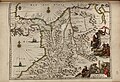
 Paraquaria vulgo Paraguay. Cum adjacentibus. R 2= 22. Pièce 71.jpg 6,704 × 4,664; 6.05 MB
-
 Paskaert van Guiana van R. de Suriname tot R. de las Amazonas. R 2= 22. Pièce 69.jpg 8,800 × 6,904; 11.56 MB
-

-
 Terra Firma et novum regnum Granatense et Popayan. R 2= 22. Pièce 66.jpg 6,752 × 4,624; 6.34 MB
-
 Venezuela cum parte australi Novæ Andalusiæ. R 2= 22. Pièce 64.jpg 6,752 × 4,688; 6.98 MB


